Cenote Rainbow
Bucear en una cenote sólo es posible con un guía calificado. Hay algunos bases de buceo locales que ofrecen bucear en una cenote.
The diving in a cenote is only possible with a qualified guide. There are a few of local diving-bases which offer the diving in a cenote.
Das Betauchen der Cenoten ist nur mit einem entsprechend ausgebildetem Führer möglich. Es gibt eine Reihe lokaler Tauchbasen, die das Betauchen von Cenoten anbieten.

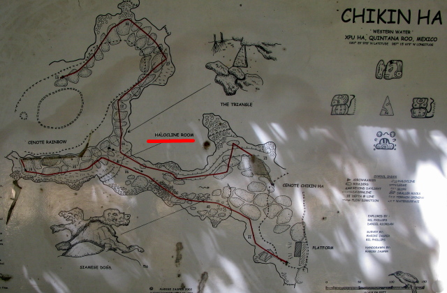
Figura2: Cenote - Halocline se marca en rojo
figure2: Cenote - Halocline is red marked
Bild2: Cenote - Halokline ist rot markiert


Situación geológica
La península de Yucatán era un arrecife de coral hace muchos millones de años. Durante las diferentes glaciaciones inundación y secado del arrecife fueron cambiando y se formó una enorme meseta de piedra caliza. Si bien los períodos secos del dióxido de carbono en la atmósfera conectada con la lluvia a una especie de ácido carbónico y permeó en la piedra caliza blanda y se solubilización del mismo. Sistemas de cuevas magníficas fueron creados, que se encuentran por debajo de Yucatán completa. Partes de los sistemas de cuevas están frecuentemente colapsando debido a la erosión de proceder de forma continua - Cenotes se forman. Durante las inundaciones periódicamente existentes ya través de las conexiones existentes al mar éstas cuevas refugio se llena parcialmente con agua de mar. Durante el período de lluvia la masa de agua escurra a través del karst. Que tanto existen depósitos de agua dulce dentro de la cueva por encima del agua de mar en orden uno encima del otro, pero no mezcla (agua dulce-lente). En el interior de la cueva se ha formado una haloclina. El espesor de la haloclina está aumentando desde unos pocos metros cerca del mar hasta aprox. 30 metros en el interior del país. En la gama de halocline la sección transversal de la cueva será más ancho debido a mezclar-corrosión.
Mezclar-corrosión
Existe mezclar-corrosión debido a diferentes aguas calizas saciado. Se crea un nuevo potencial solución para la piedra caliza en la haloclina. Mezclar-corrosión ocurre en todas partes, donde dos aguas equilibradas con diferentes contenidos de cal o diferente temperatura del agua se están mezclando. Debido a la mezcla de las aguas, tanto la nueva mezcla contiene CO2 repuesto, que inmediatamente solutos piedra caliza. Esta cantidad soluted, además, de la piedra caliza crece con la diferencia de las dos fuentes de agua: Por ejemplo: 2 aguas se mezclan con el contenido de cal de 10 mg / ly 400 mg / l en proporción 1: 1, por lo que la piedra caliza soluted adicional es 51 mg / l.
Sus tareas
Mientras que el buceo, prestar atención a la haloclina. (ver Figura2)
Tarea 1: ¿En la que la profundidad se puede encontrar aquí la haloclina?
Tarea 2: Describa lo que se puede ver en los bordes de la cueva en el sector de la haloclina.
Tarea 3: Piensa, por qué el agua del mar es inferior y el agua fresca es superior. Sólo hay una razón, un nombre.
Opcional, pero nos gustaría que aparezcan fotos de su buceo, su cuaderno de bitácora de buceo o el cenote.
Puedes subscribir esta cacha inmediatamente después de visitar el earthcache y responder a las preguntas. Nosotros contestaremos a te, ya sea para felicitar o para resolver preguntas abiertas.
Por favor escribir sus respuestas a nuestra perfil o
black-tomcat@vodafonemail.de
¡Ahora, prepárate para saltar en el agua!
Muchas gracias a SH531 para la traducción.


Geological situation
The Yucatan Peninsula was a coral reef many millions of years ago. During different ice ages flooding and drying of the reef were switching and it was formed a huge limestone plateau. While dry periods the atmospheric carbon dioxide connected with the rain to a kind of carbonic acid and permeated into the soft limestone and was solubilizing the same. Magnificent cave systems were created, which are located beneath complete Yucatan. Parts of the cave systems are frequently collapsing due to continuously proceeding erosion – Cenotes are formed. During periodically existing flooding and through existing connections to the sea these caves haven been filled partly with seawater. During the rain period the mass of water drain off through the karst. Freshwater deposits inside the cave above the seawater in order that both exist one above the other, but not mixing (Freshwater-lense). Inside of the cave there is formed a halocline. The thickness of the halocline is increasing from a few meters near the sea up to approx. 30 meters inside of the country. In the range of halocline the cross section of the cave will be wider due to mix-corrosion.
Mix-corrosion
Mix-corrosion exists due to different limestone satiated waters. New solution potential for limestone at the halocline is created. Mix-corrosion happens everywhere, where two balanced waters with different lime content or different water temperature are mixing. Due to the mixing of both waters the new mixture contains spare CO2, which immediately solutes limestone. This additionally soluted amount of limestone grows with the difference of the two source waters: E.g. 2 waters are mixing with lime content of 10 mg/l and 400 mg/l in ratio 1:1, so the additional soluted limestone is 51mg/l.
Your tasks
While diving, pay attention to the halocline. (look figure2)
Task 1: in which depth you can find here the halocline?
Task 2: Describe what you can see at the edges of the cave at the sector of the halocline.
Task 3: Think about, why the sea water is below and the fresh water is above. There is only one reason, name it.
Optional, but we would like to see pictures of your diving, your diving logbook or the cenote.

You can log this cache immediately after visiting the earthcache and the answering the questions. We will reply in any case, either to congratulate or to solve open matters.
Please send your answers to our account or to
black-tomcat@vodafonemail.de
Now, get ready to jump in the water!
Special thanks to SH531 for translation!

Geologische Situation
Die Halbinsel Yucatan war vor vielen Millionen Jahren ein Korallenriff. Im Laufe verschiedener Eiszeiten wechselte Überflutung und Trockenfallen des Riffs und es hat sich ein mächtiges Kalksteinplateau gebildet. In den Trockenphasen hat sich atmosphaerisches Kohlendioxyd mit dem Regen zu einer Kohlensäure verbunden und ist in den weichen Kalkstein eingedrungen und hat ihn aufgeloest. Es sind gewaltige Höhlensysteme entstanden, die unter ganz Yucatan vorhanden sind. Durch stetig vornschreitende Erosion brechen immer wieder Teile der Höhlensysteme ein - es entstehen die Cenoten. Bei den periodisch auftretenden Überflutungen und durch bestehende Verbindungen zum Meer sind die Höhlen teilweise mit Salzwasser gefüllt worden. Während der Regenzeit fließen die Wassermassen in das Karstgestein ab. Süßwasser lagert sich innerhalb der Höhlengänge auf dem Salzwasser ab, so dass beides übereinander existiert, sich aber nicht vermischt (Süßwasserlinse). Innerhalb der Höhlen kommt es zur Ausbildung einer Sprungschicht, der sogenannten Halokline. Die Tiefe der Halokline nimmt von wenigen Metern in Meeresnähe kontinuierlich bis zu etwa 30 Metern im Landesinneren zu. Durch Mischungskorrosion kommt es im Bereich der Halokline zu einer Verbreiterung des Höhlenquerschnitts.
Mischungskorrosion
Mischungskorrosion entsteht durch die unterschiedlich kalkgesättigten Wassermassen. Es entsteht neues Lösungspotential für Kalk an der Halokline. Mischungskorrosion findet überall da statt, wo sich zwei Gleichgewichtswässer mit unterschiedlichen Kalkgehalten oder verschiedenen Wassertemperaturen mischen. Durch die Vermischung der beiden Wässer enthält die neue Mischung überschüssiges CO2, das sofort wieder Kalk löst. Diese zusätzlich gelöste Kalkmenge wächst mit dem Ausmaß des Unterschieds der beiden Ausgangskonzentrationen: Vermischen sich z.B. zwei Wässer mit 10 mg/l und 400 mg/l gelösten Kalk im Verhältnis 1:1, so beträgt die zusätzlich gelöste Kalkmenge 51 mg/l.
Deine Aufgaben
Achte bei deinem Tauchgang auf die Halokline. (siehe Bild2)
Aufgabe1: In welcher Tiefe befindet sich die Halokline hier?
Aufgabe2: Beschreibe, was du im Bereich der Halokline an den Höhlenwänden erkennst.
Aufgabe3: Überlege, warum das Salzwasser unten und das Süßwasser oben ist. Es gibt nur einen Grund, nenne ihn.
Optional, aber sehr gerne sehen wir Bilder von deinen Eindrücken beim Tauchgang, ein Foto deines Tauchlogbuches oder der Cenote.

Nach dem Besuch des Earthcaches und der Beantwortung der Fragen darfst Du sofort loggen. Wir melden uns auf jeden Fall, um dir deinen Erfolg mitzuteilen oder offene Fragen zu klären.
Die Antworten bitte an unser Profil oder
black-tomcat@vodafonemail.de
So, nun aber ab ins Wasser!
Für die Übersetzungen danken wir SH531 ganz herzlich!

youtube video: Halocline
Quellen / sources:
https://de.wikipedia.org/wiki/Cenote
https://de.wikipedia.org/wiki/Halokline
http://www.angewandte-geologie.geol.uni-erlangen.de/mischung.htm
http://www.geo.uzh.ch/~stgruber/teaching/Mischungskorrosion.pdf
http://www.nationalflaggen.de/flaggen/nationen/index.html/
Bilder/pictures ©black-tomcat