It is recommended
to complete this earthcache from the bike trail that extends to
include both areas needed to view, therefore a bicycle is
recommended for ease of access. The terrain and difficulty
ratings are based on this method. However, automobile parking
spots are provided for walking access. Please be careful when
crossing roads.
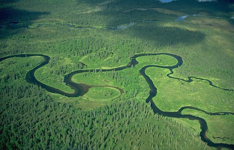
 When a river reaches a low-lying plain, often in its
final course to the sea or a lake, it meanders widely. In the
vicinity of a river bend, deposition occurs on the convex bank (the
bank with the smaller radius). In contrast, both lateral erosion
and undercutting occur on the cut bank or concave bank (the bank
with the greater radius.) Continuous deposition on the convex bank
and erosion of the concave bank of a meandering river cause the
formation of a very pronounced meander with two concave banks
getting closer. The narrow neck of land between the two neighboring
concave banks is finally cut through, either by lateral erosion of
the two concave banks or by the strong currents of a flood. When
this happens, a new straighter river channel is created and an
abandoned meander loop, called a cut-off, is formed. When
deposition finally seals off the cut-off from the river channel, an
oxbow lake is formed. This process can occur over a time scale from
a few years to several decades and may sometimes become essentially
static.
When a river reaches a low-lying plain, often in its
final course to the sea or a lake, it meanders widely. In the
vicinity of a river bend, deposition occurs on the convex bank (the
bank with the smaller radius). In contrast, both lateral erosion
and undercutting occur on the cut bank or concave bank (the bank
with the greater radius.) Continuous deposition on the convex bank
and erosion of the concave bank of a meandering river cause the
formation of a very pronounced meander with two concave banks
getting closer. The narrow neck of land between the two neighboring
concave banks is finally cut through, either by lateral erosion of
the two concave banks or by the strong currents of a flood. When
this happens, a new straighter river channel is created and an
abandoned meander loop, called a cut-off, is formed. When
deposition finally seals off the cut-off from the river channel, an
oxbow lake is formed. This process can occur over a time scale from
a few years to several decades and may sometimes become essentially
static.
 Gathering of
erosion products near the concave bank and transporting them to the
convex bank is the work of the secondary flow across the floor of
the river in the vicinity of a river bend. The process of
deposition of silt, sand and gravel on the convex bank is clearly
illustrated in point bars.
Gathering of
erosion products near the concave bank and transporting them to the
convex bank is the work of the secondary flow across the floor of
the river in the vicinity of a river bend. The process of
deposition of silt, sand and gravel on the convex bank is clearly
illustrated in point bars.
 It is instructive to
demonstrate the effect of the secondary flow using a circular bowl.
Partly fill the bowl with water and sprinkle dense particles such
as sand or rice into the bowl. Set the water into circular motion
with one hand or a spoon. The dense particles will quickly be swept
into a neat pile in the center of the bowl. This is the mechanism
that leads to the formation of point bars and contributes to the
formation of oxbow lakes. The primary flow of water in the bowl is
circular and the streamlines are concentric with the side of the
bowl. However, the secondary flow of the boundary layer across the
floor of the bowl is inward toward the center. The primary flow
might be expected to fling the dense particles to the perimeter of
the bowl, but instead the secondary flow sweeps the particles
toward the center.
It is instructive to
demonstrate the effect of the secondary flow using a circular bowl.
Partly fill the bowl with water and sprinkle dense particles such
as sand or rice into the bowl. Set the water into circular motion
with one hand or a spoon. The dense particles will quickly be swept
into a neat pile in the center of the bowl. This is the mechanism
that leads to the formation of point bars and contributes to the
formation of oxbow lakes. The primary flow of water in the bowl is
circular and the streamlines are concentric with the side of the
bowl. However, the secondary flow of the boundary layer across the
floor of the bowl is inward toward the center. The primary flow
might be expected to fling the dense particles to the perimeter of
the bowl, but instead the secondary flow sweeps the particles
toward the center.
 The curved path of a
river around a bend causes the surface of the water to be slightly
higher on the outside of the river bend than on the inside. As a
result, at any elevation within the river the water pressure is
slightly greater near the outside of the river bend than on the
inside. There is a pressure gradient toward the convex bank which
provides the centripetal force necessary for each parcel of water
to follow its curved path. The boundary layer flowing along the
floor of the river is not moving fast enough to balance the
pressure gradient laterally across the river. It responds to this
pressure gradient and its velocity is partly downstream and partly
across the river toward the convex bank. As it flows along the
floor of the river it sweeps loose material toward the convex bank.
This flow of the boundary layer is significantly different from the
speed and direction of the primary flow of the river, and is part
of the river's secondary flow.
The curved path of a
river around a bend causes the surface of the water to be slightly
higher on the outside of the river bend than on the inside. As a
result, at any elevation within the river the water pressure is
slightly greater near the outside of the river bend than on the
inside. There is a pressure gradient toward the convex bank which
provides the centripetal force necessary for each parcel of water
to follow its curved path. The boundary layer flowing along the
floor of the river is not moving fast enough to balance the
pressure gradient laterally across the river. It responds to this
pressure gradient and its velocity is partly downstream and partly
across the river toward the convex bank. As it flows along the
floor of the river it sweeps loose material toward the convex bank.
This flow of the boundary layer is significantly different from the
speed and direction of the primary flow of the river, and is part
of the river's secondary flow.
When a fluid follows a curved path, such as around a circular bowl,
around a bend in a river or in a tropical cyclone, the flow is
described as vortex flow – the fastest speed occurs where the
radius is smallest, and the slowest speed occurs where the radius
is greatest. The higher fluid pressure and slower speed where the
radius is greater, and the lower pressure and faster speed where
the radius is smaller, are all consistent with Bernoulli's
principle.
Oxbow lakes may be formed when a river channel is straightened
artificially to improve navigation or for flood alleviation. This
occurred notably on the upper Rhine in Germany in the nineteenth
century.
An example of an entirely artificial waterway with oxbows is the
Oxford Canal in England. When originally constructed it had a very
meandering course, following the contours of the land, but the
northern part of the canal was straightened out between 1829 and
1834, reducing its length from 91 to 77 and a half miles
(approximately) and leaving a number of oxbow-shaped sections
isolated from the new course.
This site was selected because it is an oxbow in progress.
There are two channels of flowing water remaining. As this is
an oxbow yet to be, one must consider the cause of this particular
formation. Water followed the contours and soft subsoil of
the area. Unlike most oxbows, this one did not come to be by
erosion. This site represents another significant cause of
oxbow formation: Flooding.
Some time in the distant past, floods did in fact erode a new
channel, but it wasn't as slow a process as other oxbow
formations. This is indicative of the large area between the
estuary inlet and outlet into the main channel. Return in a
century or so and you will be able to log a find for a completed
oxbow.
To log this earthcache you must
complete the following tasks and answer the questions below.
Additionally, you must visit two locations and take a picture of
you and/or your GPS unit in the picture at each location as
described below.
At location one, at the posted coordinates above, N 39° 50.730'
W084° 10.370', get the required picture from such an angle to show
the confluence where the original estuary channel branches off from
the current main channel of the river.
Answer the following questions:
1 - What is the width of the main channel of the river at this
location?
2 - What is the width of the estuary channel where it branches off
at this location?
3 - How tall is the concrete structure atop the levy near GZ?
4 - What is the identification number of the telephone pole nearest
to GZ?
At location two, at the
posted coordinates above, N 39° 49.788' W084° 09.881', get the
required picture from such an angle to show the confluence where
the original estuary channel branches off from the current main
channel of the river.
Answer the following questions:
5 - How wide is the main channel of the river at this
location?
6 - How wide is the estuary channel at this location?
7 - How wide is the bridge spanning both the estuary and the main
channel?
8 - How many reflectors are on the roadway side of the concrete
divider between the roadway and the bike path?
I reserve the
right to delete logs of finders that do not complete all
requirements of this earthcache.
Congrats to tominohio for
FTF on 7-26-10
