Once, more than 200 million years ago, a great ocean covered the
Cloudland State Canyon Park. The mountain was created by either a
single earthquake, or more likely, several earthquakes. When it was
first formed the entire mountain was still underwater, but slowly
the water subsided, until the rim of the canyon was a beach on this
ocean. As the great ocean dried Daniel Creek took over and
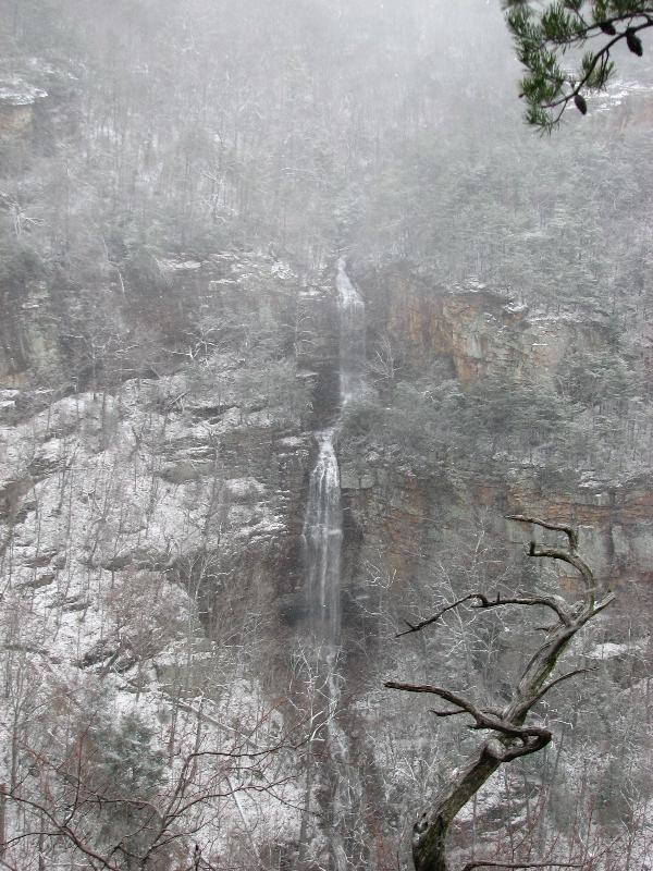
continued eroding the rock and creating Water Falls like Wet
Weather Water Falls Earth Cache.
A wet weather water fall is active during heavy rain fall or snow
melt. You may find this water fall trickling water or you may find
gushing water rushing over its edge. Regardless its still a water
fall formed over millions of years.
A waterfall is usually a geological formation resulting from water,
often in the form of a stream, flowing over an erosion-resistant
rock formation that forms a sudden break in elevation or nickpoint.
Some waterfalls form in mountain environments where the erosive
water force is high and stream courses may be subject to sudden and
catastrophic change. In such cases, the waterfall may not be the
end product of many years of water action over a region, but rather
the result of relatively sudden geological processes such as
landslides, faults or volcanic action.
Typically, a river flows over a large step in the rocks which may
have been formed by a fault line. Over a period of years, the edges
of this shelf will gradually break away and the waterfall will
steadily retreat upstream, creating a gorge of recession. Often,
the rock stratum just below the more resistant shelf will be of a
softer type, meaning undercutting, due to splashback, will occur
here to form a shallow cave-like formation known as a rock shelter
or plunge pool under and behind the waterfall. Eventually, the
outcropping, more resistant cap rock will collapse under pressure
to add blocks of rock to the base of the waterfall. These blocks of
rock are then broken down into smaller boulders by attrition as
they collide with each other, and they also erode the base of the
waterfall by abrasion, creating a deep plunge pool.
Streams become wider and more shallow just above waterfalls due to
flowing over the rock shelf, and there is usually a deep pool just
below the waterfall because of the kinetic energy of the water
hitting the bottom.
Waterfalls can occur along the edge of glacial trough, whereby a
stream or river flowing into a glacier continues to flow into a
valley after the glacier has receded or melted. The large
waterfalls in this valley are examples of this phenomenon. The
rivers are flowing from hanging valleys.
Block: Water descends from a relatively wide stream or
river.
Cascade: Water descends a series of rock steps. Cataract:
A large waterfall.
Fan: Water spreads horizontally as it descends while
remaining in contact with bedrock.
Horsetail: Descending water maintains some contact with
bedrock.
Plunge: Water descends vertically, losing contact with
the bedrock surface.
Punchbowl: Water descends in a constricted form, then
spreads out in a wider pool.
Segmented: Distinctly separate flows of water form as it
descends.
Tiered: Water drops in a series of distinct steps or
falls.
Multi-Step: A series of waterfalls one after another of
roughly the same size each with its own sunken plunge pool.
This Earth Cache has been placed with permission from the Cloudland
Canyon State Park. Always ask permission before placing a earth
cache like this one.
To get credit for this EC, post a photo of you with GPS and the
Wet Weather Water Falls in the back ground. Please answer the
following questions.
1. What type of water fall do you think this is? (Use chart on
cache page)
2. What is the height of the water fall?
3. How any other water falls are across the canyon from the viewing
area?
Logs with no photo of the actual cacher logging the find or
failure to answer questions will result in a log deletion.
Exceptions will be considered if you contact me first (I realize
sometimes we forget our cameras or the batteries die). Logs with no
photos will be deleted in seven days of posting.
I have used sources available to me by using google search to get
information for this earth cache. I am by no means a geologist. I
use books, internet, and asking questions about geology just like
99.9 percent of the geocachers who create these great Earth Caches.
I enjoy Earth Caches and want people to get out and see what I see
everytime I go and explore this great place we live in.