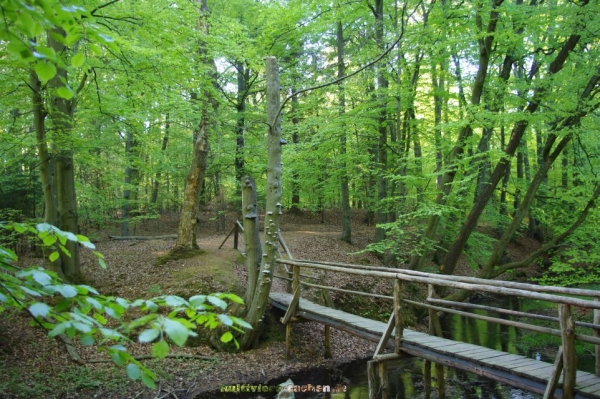
Dies ist kein schneller Park und Grab. Ihr werdet auf der gesamten Route keine Infotafel finden. Die Gesamtroute beträgt mindestens 25 km, die aber immer mit einem KFZ befahrbar sind, zumindest wenn ihr kein tiefergelegten Golf I fahrt. Ihr braucht ein Hilfsmittel zur Ermittlung der Fießgeschwindigkeit, ein Metermaß zum ermitteln der Stricklänge und eine Stoppuhr für die Zeitmessung. Wir haben uns 2 Hilfsmittel gebaut: das erste aus 3 Korken die wir aneinander gebastelt haben, das zweite besteht aus einem PETling. Wir maßen die Zeit die das Hilfsmittel für 5 Meter Strecke brauchte. Wir wünschen euch viel Spaß am Flußlauf der Schaale.
Die Schaale ist ein ca. 40 Kilometer langer Nebenfluss der Sude und der natürliche Abfluss des Schaalsees.
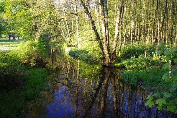
Die Schaale tritt am Südufer über ein Wehr der stillgelegten Schaalmühle aus dem Schaalsee aus und verläuft zunächst südwärts durch ein Sandergebiet. Dann folgen Zuflüsse des Hammerbachs, die Kleine Schaale, der Faule Bach und die Schilde .
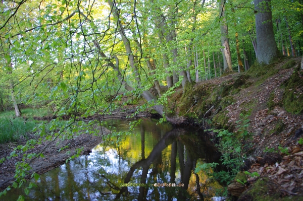
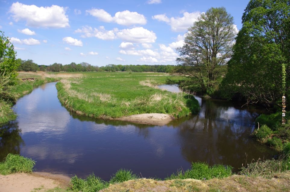
Dann nimmt das Gefälle der Schaale ab und es bilden sich Mäander .
Auf Höhe Zahrensdorf erreicht die Schaale das Elbe – Urstromtal . Ab Hühnerbusch ist der Flusslauf begradigt ist, wobei das ursprüngliche Flussbett erhalten wurde und Nebenarme bildet.
Entstehung
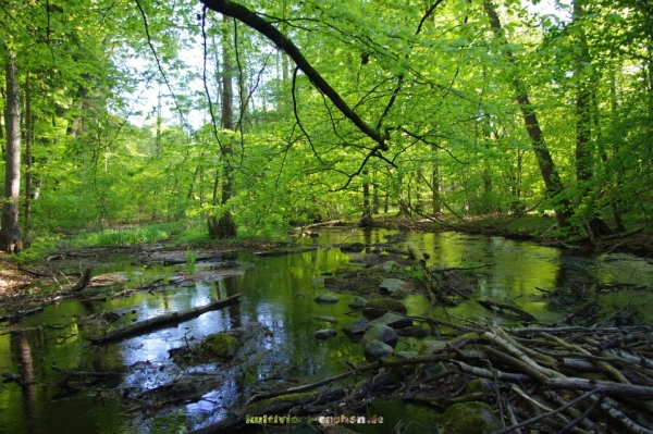
Entstanden ist die Schaale als Schmelzwasserablauf des Eisvorstoßes des frankfurter Stadiums der Weichseleiszeit. Sie verläuft mehrheitlich in einem bis zu zehn Meter in den Sander eingesenkten Kastental mit ausgeprägten, unterschiedlichen alten Gleit- und Prallhängen sowie Terrassen. Im Flusslauf sind Findlinge und Schotter zu finden die durch Freispülungen saalekaltzeitlicher Moränenzüge entstanden sind.
Historische Nutzung
In der Zeit von 1564 bis 1830 war der Flusslauf durch 13 Stau- und Kastenschleusen geregelt.Die Schaale war bereits im 17. Jahrhundert wichtiger Handelsweg für die Salzschifffahrt, wodurch Zarrentin die Funktion eines Marktfleckens zukam. Ebenfalls wurde die Lüneburger Saline mit am Flusslauf gewonnenen und zum Transport geflößten Holz versorgt. Erst nach Stilllegung der Lüneburger Saline um 1830 kam es zu Wiederaufforstungen.
Zeitweilig wurde in Konkurrenz zum Stecknitz-Kanal der Gedanke verfolgt, Wismar für Zwecke der Schifffahrt mit dem Schaalsee zu verbinden, um über die Schaale zur Elbe zu gelangen.
Dies scheiterte allerdings an der Uneinigkeit zwischen Herzog Albrecht VII und seinem Bruder Heinrich V.
Mäander
Mäander ist die Bezeichnung für eine Abfolge von Flussschlingen, die sich in den Abschnitten mit einem geringen Sohlgefälle und gleichzeitig transportiertem Geschiebe (Sand, Kies, Steine) bilden.
Eine einzelne Flussschlinge im Flusslauf wird noch nicht als Mäander bezeichnet.
Gebildet werden Mäander, wenn eine Wasserströmung
entlang des Flussbodens von der kurvenäußeren Seite zur
kurveninneren Seite fließt und dann auf der Oberfläche zurück
fließt. Durch diese Strömung wird Material vom Flussbett nach innen
transportiert und die Kurven werden immer
weiter.
Diese Strömung entsteht
so:
-
Angenommen wir haben ein Kräftegleichgewicht,
dann wird der Wasserstand an der kurvenäußeren Seite höher sein,
als auf der Kurveninneren Seite. Angenommen im ganzen Kurvenbereich
herrscht gleicher Wasserstand: Jetzt herrscht eine Kraft gen
Kurveninneren. Allerdings wirkt auf das Wasser die
Zentrifugalkraft. Somit hat man eine Strömung um die Kurve, ohne
Querzirkulation verursacht zu
haben.
-
Da aber nie ein Kräftegleichgewicht herrscht,
herrscht am Flussbett eine Reibungskraft. Dies senkt zunächst die
Geschwindigkeit am Flußbett. Die Druckkraft bleibt gleich, weil die
Oberflächenspannung der Wasseroberfläche hierdurch unverändert
bleibt. Allerdings sinkt die Zentrifugalkraft, dadurch erfolgt eine
Beschleunigung der Strömung in Richtung
Kurveninneres.
-
An der Oberfläche entsteht aus Gründen der
Massenerhaltung eine Komponente der Strömung in Richtung
Kurvenäußeres. Jeder Flussbootfahrer kennt diese Strömung, die
nicht durch die Zentrifugalkraft ausgelöst wird. Diese wird exakt
balanciert durch den höheren Wasserstand an der kurvenäußeren
Seite.
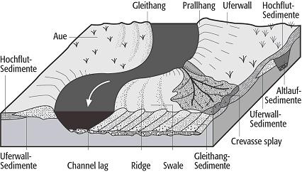
Quelle : Wikipedia


Um diesen Earthcache loggen zu können beantwortet einfach folgende Fragen mit Euren eigenen Worten .


1:      Im Anhang findet Ihr insgesamt 10 Messpunkte, unterteilt in 4 Zonen (1-3 Zone und Finalzone). Baue ein kleines Hilfsmittel ( zb. mehrere Korken, oder PETlinge an einer Angelschnur )und messe die Fließgeschwindigkeit an mindestens einer Messstation pro Zone.

2:      Am Messpunkt 10, bzw. am Photopoint findest du ein faszinierendes geologisches Phänomen. Beschreibe uns was Du hier sehen kannst, und an Hand dessen die Entstehung des faszinierenden Phänomens.

3:      Bringe die vorher empirisch ermittelten Werte in Korrelation zu der obigen Aufgabe.


4:      Warum entsteht gerade hier das Phänomen, und erkläre dies anhand eines kleinen Modells .

5:      Über ein kreatives Foto von Euch und/ oder Eurem Modell würden wir uns sehr freuen.
Mailt eure Antworten bitte an:Earthcache@kultiviert-cachen.de oder über unser Profil und vergesst bitte nicht euren Nick mit anzugeben. Außerdem gilt natürlich, jedes Team mailt seine Antworten selber.
This isn't a quick park and grab You won't find any Infoboard
at the entire route. The route is at least 25 km long, but it is
totally passable with a car, at least if you don't drive tuned Golf
I ;). You need a tool to determine the flow rate,a measuring tape
to determine the length of the rope and a stopwatch for the timing.
We have built two tools: the first made of 3 cork we have tinkered
together, the second consists of a PETling. We measured the time
that the tools needed for a 5 meters distance. We wish you so much
fun on the river of Schaale.
The Schaale is a 40 km long
tributary of the Sude and the natural flow out of the
Schaalsee.
The Schaale occurs over a weir at the closed Schaalmill on the
south bank of the Schaalsee, and runs south through a sand area.
During its flow Hammerbach, the kleine Schaale, the Faule Bach and
the Schilde.
Shortly after the estuary of the Schilde the incline flattens and
it forms meanders.
On reaching the height Zahrensdorf Schaale reaches the Elbe
Urstrom. From Hühnerbusch is the river had been straightened, the
original river bed had been kept and builds side
arms.
Formation
Meander formation is a result of natural
factors and processes. The waveform configuration of a stream is
constantly changing. Once a channel begins to follow a sinusoidal
path the amplitude and concavity of the loops increase dramatically
due to the effect of helical flow sweeping dense eroded material
towards the inside of the bend, and leaving the outside of the bend
unprotected and therefore vulnerable to accelerated erosion,
forming a positive feedback loop. In the words of Elizabeth A.
Wood:
... this
process of making meanders seems to be a self-intensifying process
... in which greater curvature results in more erosion of the bank,
which results in greater curvature
...
Flow of a
fluid around a bend is vortex flow in order to conserve angular
momentum. The speed of flow on the inside of the bend is fastest,
and on the outside of the bend is slowest. The water surface is
also super-elevated towards the outside of the bend, so on the
floor of the channel the water pressure is greater on the outside
of the bend than on the inside of the bend. This pressure gradient
drives a cross-current towards the inside of the
bend.
In order for
a flow to have a curved path there must be a centripetal force
inward that is present (this is similar to spinning a bucket on a
string, but here we do not have solid body rotation ie. a spinning
record). The force presents itself as a pressure gradient outwards
(larger pressure on the outside of the bend then inside) or from a
change in elevation at the free surface (larger elevation on the
outside of the bend). At the free surface of the river the pressure
must be constant, equal to atmospheric pressure, so the elevation
must change to maintain the curved flow. In the middle (in the
vertical) of the river a pressure gradient is present to maintain
the curved flow. At the floor of the river, the no slip condition
requires no velocity. This sets up a situation that has lower
velocity at the floor which is not enough to overcome the pressure
gradient and a secondary cross flow develops (into the bend at the
floor). The secondary flow into the bend at the floor due to the
pressure gradient must eventually go up due to conservation of mass
and the flow is outward above the floor. This entire situation is
very similar to theTea leaf paradox. This secondary flow caries
sediment from the outside of the bend to the inside making the
river more
meandering.
It is a
misconception that the flow at the outside is faster then the
inside (which would be true for solid body rotation which we don't
have here), it is actually the opposite. We consider the flow to be
irrotational for the most part here, which requires the flow
outside to be slower than the flow inside (otherwise the flow would
not be
irrotational).
The
cross-current along the floor of the channel is part of the
secondary flow and sweeps dense eroded material towards the inside
of the bend. The cross-current then rises to the surface near the
inside of the bend and, moving near the surface, flows towards the
outside of the bend, forming a helical flow. The greater the
curvature of the bend, and the faster the flow, the stronger is the
cross-current and the stronger the sweeping of dense eroded
material along the floor of the channel towards the inside
bank.
The question
of formation is why streams of any size become sinuous in the first
place. There are a number theories, not necessarily mutually
exclusive.

History
Between 1564-1830 the river had been contained with 13 dams and
locks.In the 17th Century the Schaale was an important
trade route for salt shipping, and Zarrentin got the function of a
market town. The Lüneburg saline was supplied with along the river
timbered and rafted wood. The closure of the Saline Lüneburg in
1830 led to reforestation.
At this time, there had been the idea, connecting Wismar with
the Schaalsee, to have the connection towards the Elbe.
This failed, through the disagreement between Duke Albrecht VII and
his brother Henry V.
Meander
Meander is the name for a series of river bends, that form in the
sections with flatten bed slope and sediment transported at the
same time (sand, gravel, stones).
A single loop in the river flow isn't called
meanders.
Source: Wikipedia
To log this cache, simply answer the following questions with your
own words.
1: In the appendix you will find a total ammount of 10 measuring
points, divided into 4 zones (1st-3rd zone and Final Zone).Build
yourself a small tool (eg some whine-corks, or PET Preforms on a
fishing line) and measure the flow rate at least one measuring
station in each zone.
2: At the measuring point 10, or on the Photo Point you'll find a
fascinating geological phenomenon.Describe what you're seeing here,
and how this fascinating phenomenon has been formed here.
3: Bring the previously empirically determined values
in correlation with the above task.
4: Why is this phenomenon right here and explain this using a small
model.
5:We would be very happy about a creative photo of you and / or
your model.
Mail your answers
to: Earthcache@kultiviert-cachen.de or through our
profile and please do not forget to indicate your nick. Finaly
please remember, each team send its own
answers.
