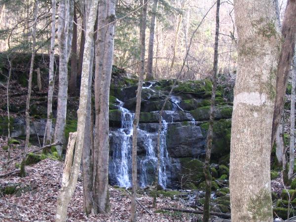
Toole Creek originates in the surrounding foothills of this part of Rich Valley. Over thousands of years it has eroded it’s way through the Toole Creek Hollow and moved boulders and formed rapids and wonderful waterfalls. In a short less than 1 mile distance, these Falls as well as the Creek empties into the North Fork of the Holston River. The North Fork flows westward and helps form the Tennessee River.
Typically, a river or the Toole Creek in this case, flows over a large step in the rocks which may have been formed by a fault line. Over a period of years, the edges of this shelf will gradually break away and the waterfall will steadily retreat upstream, creating a gorge of recession. Often, the rock stratum just below the more resistant shelf will be of a softer type, meaning undercutting, due to splashback, will occur here to form a shallow cave-like formation known as a rock shelter or plunge pool under and behind the waterfall. Eventually, the outcropping, more resistant cap rock will collapse under pressure to add blocks of rock to the base of the waterfall. These blocks of rock are then broken down into smaller boulders by attrition as they collide with each other, and they also erode the base of the waterfall by abrasion, creating a deep plunge pool.
The Toole Creek, as with other waterfalls, becomes wider and more shallow just above waterfalls due to flowing over the rock shelf, and there is usually a deep pool just below the waterfall because of the kinetic energy of the water hitting the bottom. At the Toole Creek Falls, you will see the results of this geological change. Remember, it took thousands of years for all of this to happen!
At the base of the Toole Creek falls and to your right you will find a smaller but beautiful falls from an unknown creek. The smaller creek joins Toole Creek approximately 75 yards downstream.
The Little Falls
A Classification Of The Most Common Types Of Waterfalls :
Block: Water descends from a relatively wide stream or river. Water descends a series of rock steps.
Cataract: A large waterfall.
Fan: Water spreads horizontally as it descends while remaining in contact with bedrock.
Horsetail: Descending water maintains some contact with bedrock.
Plunge: Water descends vertically, losing contact with the bedrock surface.
Punchbowl: Water descends in a constricted form, then spreads out in a wider pool.
Segmented: Distinctly separate flows of water form as it descends.
Tiered: Water drops in a series of distinct steps or falls.
Multi-Step: A series of waterfalls one after another of roughly the same size each with its own sunken plunge pool.
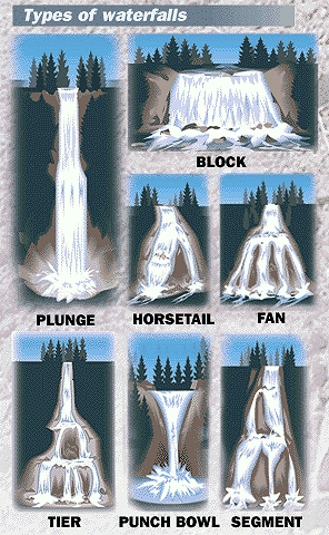
Which Is It?
In order to claim a find on this Earthcache you must: Post a photo of yourself at the base of the Falls with GPS in hand and the Falls in the background. You must also send me us an email with answers to the following questions: 1. From the list above, what type of falls are the Toole Creek Falls, 2. Estimate the width of the Falls at it's base and 3. What is the elevation at the base of the Falls (close to coordinates).
NOTE: GPS readings are problematic in this hollow so don't worry about finding the exact spots. Take your photo and elevation reading near the lower base of the big falls. We are not looking for precision.
Not just for the required photo, be sure to bring your camera for this wonderful geological exhibit of Nature.
This Earthcache was approved by the Geological Society of America
| We have earned GSA's highest level: |
 |