Devil's Elbow Quarry EarthCache
-
Difficulty:
-

-
Terrain:
-

Size:  (other)
Please note Use of geocaching.com services is subject to the terms and conditions
in our disclaimer.
DEVIL'S ELBOW QUARRY
This is an old quarry located near on the shore of the Land Between the Lakes Elbow Bay of Lake Barkley/Cumberland River. The quarry was operated mainly in the 1950'sand early 1960's to provide erosion control rip-rap for the Lawrence Memorial Bridge and U.S. Highway 68. I hope you enjoy your visit and learn a little about the limestone of western Trigg County in LBL.
TASKS
IN ORDER TO LOG THIS FIND YOU MUST:
A. Click on my profile and e-mail the answers for the following questions to me. Do not post your answers when you log in your find. Logs which do not meet the requirements to claim the find will be deleted.
- Look closely at the rock along the quarry wall. Choose a specimen of chert and describe it. Measure its length and width.
- Based on texture and the type/abundance of chert, which of the four limestones do you see.
- Is the texture of the rock along the water's edge similar or different from that of the quarry wall. If different why?
- Estimate the length, width, and depth of the quarry. Calculate the volume of rock mined from the quaary.
B. Optional, though greatly appreciated. Take and log a picture of you(and your group) standing with the quarry in the background.
CHERT
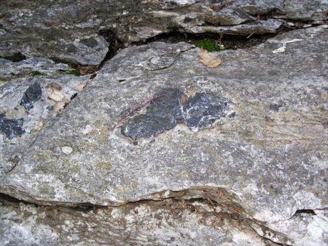 Chert is the name for a widespread type of sedimentary rock that is made of silica (silicon dioxide or SiO2). Chert can form when microcrystals of silicon dioxide grow within soft sediments that will become limestone or chalk. In these sediments, enormous numbers of silicon dioxide microcrystals grow into irregularly-shaped nodules or concretions when dissolved silica is transported to the formation site by the movement of groundwater. If the nodules or concretions are numerous, they can enlarge and merge with one another to form a nearly continuous layer of chert within the sediment mass. Chert formed in this manner is a chemical sedimentary rock.Chert occurs in a wide variety of colors. Continuous color gradients exist between white and black or between cream and brown. Green, yellow, and red cherts are also common. The darker colors can result from inclusions of sediment or organic matter. The name "flint" is often used in reference to the darker colors of chert. Red to reddish brown cherts receive their color from included iron oxide. The name "jasper" is frequently used for these reddish cherts.
LIMESTONE
A sedimentary rock consisting chiefly (more than 50% by weight or by areal percentages under the microscope) of calcium carbonate, primarily in the form of the mineral calcite. Most limestone is composed of skeletal fragments of marine organisms such as coral. Limestone makes up about 10% of the total volume of all sedimentary rocks. Limestone may be crystalline, granular, or massive, depending on the method of formation. Crystals of calcite, quartz, dolomite or barite may line small cavities in the rock. When conditions are right for precipitation, calcite forms mineral coatings that cement the existing rock grains together, or it can fill fractures.
LIMESTONE IN KENTUCKY
Continuing growth in commercial, residential, and highway construction industries creates a strong demand for construction aggregate in Kentucky. The term aggregate refers to the hard, inert rock particles that are combined with binding materials to form cement concrete and asphalt concrete, or are used alone. Large reserves of limestone suitable for a variety of industrial uses are located in western Kentucky. The major lithologic units in the area are the Mississippian Meramecian limestones, including the Fort Payne Formation and Warsaw, Salem, St. Louis, and Ste. Genevieve Limestones. High-calcium limestone zones occur within the Warsaw and Ste. Genevieve Limestones. The large areal extent of the Ste. Genevieve makes it a valuable source of limestone in Kentucky. Deposits located close to transportation routes, particularly river transportation, are vital to a large, viable mining operation.
Mining involves digging resourses out of the earth. Open pit mining is used when the resource is close to the surfaces. Underground mining uses tunnels dug to reacher deeper material.
The basic steps to open pit mining include:
- Removal of overburden (vegetation and topsoil) to expose the mineral layer.
- Drilling to determine the extent of the mineral layer and the post-mining processing at the mill.
- Blasting is used to break up large sheets of primary rock. A gris of several holes is drilled in the rock and filled with explosives.
- Loading excavaators remove the broken rock unto trucks or barges.
- Crushing reduces the size of the aggregate so it can be transported to the mill.
- Transportation involves taking "waste rock" to waste dumps and mineral rock to the mills to be processed.
Underground mining involves:
- Digging vertical or inclined tunnels to reach the mineral layer.
- Rock is blasted at the mine face.
- Blasted aggregate is loaded into big trucks and carried to crushers.
- Crushers break rock into smaller enough pieces to be carried to the surface by conveyer.
- At the surface rock is sorted into different sizes, then it is transported to various mills to be processed.
LIMESTONE IN WESTERN TRIGG COUNTY & LBL
There four basic types of limestone found through out the area:
- Fort Payne Formation - Very light to light-olive-gray, thin to thick-bedded fine to coarse-grained bioclastic limestone containing abundant nodules and beds of light to dark-grey chert. Average thickness about 200 feet.
- St. Louis Limestone - many nodules and blocks of dark, fine-textured chert in sandy clay. Grayish-brown, medium-bedded limestone. Maximum preserved thickness about 50 feet.
- Warsaw Limestone - contains thick deposits of high-calcium limestone and is a medium gray, fine- to coarse-grained limestone containing fossil material in a chalk-like matrix. Porous chert blocks. Thickness about 60 feet.
- St. Genevieve Limestone - Gray limestone, slightly oolitic and cherty, with some green shale and fine-grained sandstone. Maximum preserved thickness 70 feet.
- Geocache is placed on LBL managed property with permission.
- It is the visitors responsibility or orient themselves with policies and rules pertaining to this Department managed site.
- Do not climb the vertical walls at the quarry or dive into the waters below. When exploring the rocky ledge, please gauge your own abilities carefully.
Additional Hints
(No hints available.)