History:
You may never have heard of Christadelphians before - and you could be forgiven for that! The Christadelphians (taken literally, 'brothers and sisters in Christ') are a small Christian denomination who base their beliefs solely on careful study and interpretation of the Bible. Globally, membership is estimated at only around 50,000; about 20,000 of these can be found in the UK, spread across 300 or so churches (often referred to as 'ecclesias', from the Greek). Each church is run by its own congregation, with services led by baptised members rather than a paid clergy. The movement is relatively young in comparison to the larger more mainstream Christian groups, having its origins in the mid 19th century. Although some of the group's beliefs differ noticeably from mainstream Christianity (perhaps most notably as a 'non-Trinitarian' denomination) there is of course a lot of common ground.
The Oxford Christadelphian Church is found at the end of Tyndale Road, between Cowley Road and St Clements. However, neither the church nor the road currently bear their original names!
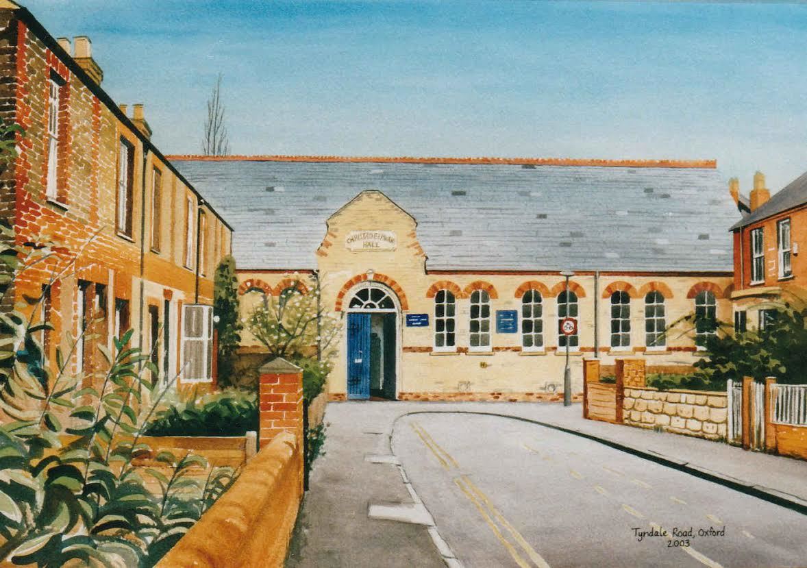
Picture used with permission of the artist, Daniel Drury.
The church began life in 1883 as the St Clements Mission Chapel, used by the Wesleyan Methodists. However, towards the end of the century the Methodists experienced rapid growth in numbers and soon outgrew the chapel. This led to the building of a new church, Wesley Hall, on the corner of Cowley Road and Jeune Street, which opened its doors in September 1904, changed its name to the Cowley Road Methodist Church in 1934, and is still open for worship today.
Meanwhile, a Christadelphian community had been growing in Oxford and by 1899 were holding public meetings in a rented room in a building on the corner of St Clements and Boulter Street. By 1904 membership had grown to 51 and a new base was required. In 1905 the St Clements Mission Chapel was purchased from the Methodists for £830 and rebranded as the Oxford Christadelphian Hall, and has been in use by Oxford's Christadelphians ever since.
All this time, the street on which the chapel stood was called 'William Street'. However, in 1929 the boundaries of the City of Oxford were extended to include some of the surrounding towns and villages; this included the parishes of Headington and New Marston - both of which also contained a 'William Street'. All three names were retained for a further 30 years until some point in the late 1950's when it was decided that this was really rather confusing and the three streets should have unique monikers. William Street in New Marston retained the name - unusual, since in most similar situations it is the original Oxford street that has been allowed to remain unchanged - while William Street in Headington became Wilberforce Street (see what they did there?!) and the William Street on which the chapel stands became Tyndale Road.
Given the presence of the church this name change is perhaps particularly apt, since William Tyndale (c. 1494-1536) was an English scholar who studied at Magdalen Hall (now Hertford College) in Oxford and a gifted linguist who became a leading figure in Protestant reform, perhaps best known for his translation of the Bible into English. In 1525-26, the publication of the Tyndale New Testament marked the first time that the New Testament - usually only read in Latin by members of the clergy - had been made publicly available in a language that could be understood by the man in the street. Its distribution was strongly opposed by senior members of the Roman Catholic Church who feared a sharp loss of the power they held in society if Christians could read the Bible in their own language. With the support of King Henry VIII, copies of the book were rounded up and burned, and Tyndale had to go into hiding in continental Europe where he continued his work until he was betrayed to the authorities in 1535 and imprisoned in the castle of Vilvoorde near Brussels, before being executed for heresy in 1536 by being strangled to death and burned at the stake. Only three copies of the first edition survive today, including one in the British Library.
The cache:
That's the history - now where's the cache?! To find it you need to head to the church and collect some easily accessible pieces of information. The starting point for this cache is N51 44.996, W001 14.495. Assume N51 and W001 for the final location, and treat the remaining 5 digits in each part as 5-digit numbers, i.e. 44,996 and 14,495. Now you'll need to do some maths...
A. To the right of the front door are a series of circular carvings, each containing a set of letters. What are the two initials in the left-most carving? Using their positions in the alphabet (1-26), call the first 'alpha' and the second 'beta'.
B. Look at the yellow hydrant sign on the wall nearby. Call the top number 'gamma' and the bottom number 'delta'.
C. Look at the metal hatch cover in the pavement near to where you are standing and find the two prominent letters. This is completely irrelevant to your calculations, but if you enjoy the cache maybe think about leaving one of these?!
D. Calculate ('alpha' + 'gamma') x ('delta' - 'gamma') and add this to 44,996. Calculate ('beta' - (2 x 'delta')) x ('gamma' - 'delta') and add this to 14,495. Put the resulting digits back into N51 XX.XXX and W001 XX.XXX respectively to find the final coordinates.
Once at GZ you should find the cache in an obvious easily accessible place - just beware of muggles as it can get quite busy. Bring a pen.
If you want to be sure you're looking in the right place, enter your calculated coords into this handy GeoChecker.com link.
The series:
Thanks to sadexploration for facilitating this extension to the Church Micro series.
If you would like to add to the Church Micro series yourself then please look here: http://churchmicro.co.uk/
There is also a Church Micro Stats & Information page that can be found at: http://www.15ddv.me.uk/geo/cm/index.html