[DE] Dieser Earthcache kann nur bei wolkenlosem Himmel gemacht werden.
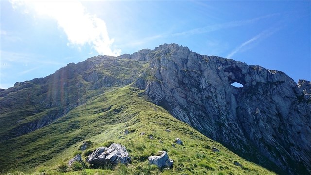
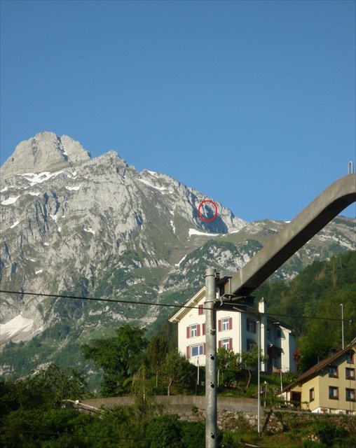
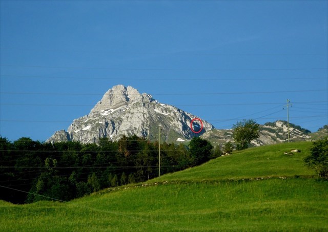
An einem klaren Tag hast du bei den Hauptkoordinaten eine gute Sicht auf den Mürtschenstock und sein Loch, das du auf der rechten Seite des Berges 30m unter dem Grat erkennen kannst, vergl. Bild unten.
[EN] This earthcache can only be made with a cloudless sky.
Going to the main coordinates on a clear day you can have a good view of the Mürtschenstock mountain and its hole that you will detect on the right side 30m below the edge, see picture below.
[DE]
Neben dem bekannteren Elmer Martinsloch, (siehe Earthcache GCPZYN), gibt es im Kanton Glarus ein weiteres grosses Felsenloch, das "Mürtschenloch", "Mürtschenfenster" oder "Stockloch" genannt wird. Es handelt sich um eine erodierte Karsthöhle von 11m Höhe und 15m Breite hoch oben am markanten Mürtschenstock.
Felsentore, auch als Bogenfelsen oder Brandungstore bezeichnet, sind brücken- oder fensterartig durchbrochene Gesteinsformationen, die durch Erosion entstehen. Je nach Größe, Form, Entstehung und Umgebung kommen andere Bezeichnungen zum Tragen, etwa Felsbrücke, Stein- oder Felsbogen, Naturbrücke oder Brandungstor. Ihre Öffnung ist vollständig von Gestein umgeben, und die Dicke der durchbrochenen Gesteinsformation ist von etwa gleicher Größenordnung wie die Breite und Höhe. Diese Erosionsformen gibt es in sehr unterschiedlichen Größen, vom kaum daumendicken Loch bis zu mehr als hundert Meter messenden Öffnungen, die von Felsen überwölbt sind.
Steinbögen und Felsbrücken entstehen im Regelfall durch Erosion, wodurch Teile natürlicher Felsformationen entfernt werden. Im mikroskopischen Bereich bedeutet dies etwa die Auflösung von Zement, im makroskopischen die Entstehung von Klüftung durch verschiedene Prozesse, so etwa Druckentlastung oder tektonische Vorgänge wie Hebung oder Dehnung, und Aufweitung durch Erosion oder Herabfallen von Material. Beide Arten der Entstehung können getrennt oder kombiniert ablaufen.
Das Mürtschenloch entstand durch Erosion. Im Laufe der Jahrtausende wurden Teile natürlicher Gesteinsformationen entfernt und der Stein rundum blieb stehen.
Am Nordhang des Mürtschenstock erhält in den Wintermonaten fast jeder Punkt seinen eigenen Sonnenstrahl aus dem Mürtschenloch, vorausgesetzt man sieht den Himmel direkt durch das Loch.
Einfach erreichbar und schön zu beobachten ist dieses Phänomen an den Hauptkoordinaten des Caches, beim Bahnhof Mühlehorn und bei Waypoint 1, jedes Jahr an den folgenden Daten.
Hauptkoordinaten des Caches: Bahnhofplatz Mühlehorn:
8. / 9. November, 14:05 Uhr
1. / 2. Februar, 14:35 Uhr
Waypoint 1: Obstalden, Stocken-Bödeli
18. – 21. November, 13:30 / 13:40 Uhr
21. – 24. Januar, 14:05 / 14:10 Uhr.
Zur Entstehung des Mürtschenlochs gibt es auch eine schöne Sage:
“Aus einem Loch auf dem Hag, zwischen Alp Säls und Alp Laubegg gelegen, sei einmal ein Drache gesprungen und Richtung Mürtschenstock geflogen. Es war ein riesiger Drache und er flog mit derartiger Schnelligkeit, dass er den Berg grad durchschlagen und ein Loch hinterlassen hat.“
Die folgenden Aufgaben sind zu erfüllen, um deinen Log gültig zu machen.
Sende eine Message via GC-Message Center an den Cache-Owner mit den Antworten auf die folgenden Fragen:
1) Auf welcher Höhe über Meer liegt das “Mürtschenloch”?
2) Aus welchem Gestein besteht der Mürtschenstock zur Hauptsache?
3) Gehe zu den Hauptkoordinaten oder zu Waypoint 1 und schätze die Distanz (Luftlinie) zum “Mürtschenloch”.
4) Freiwillig: Ein Bild zu deinem Log. Gehe zu den Haupt- oder den Waypoint 1-Koordinaten und mache ein Bild, das dich und/oder dein GPS-Gerät vor dem Mürtschenstock zeigt. (vergl. Beispiel im Anhang)
Es darf sofort geloggt werden. Bei Problemen mit deinen Antworten werde ich mich melden.
Link: https://de.wikipedia.org/wiki/Felsentor
[EN]
In addition to the better known “Martinsloch” near Elm, (see earthcache GCPZYN), there is another big natural arch in a mountain situated in the canton Glarus, called “Mürtschenloch”, "Mürtschenfenster" or "Stockloch”. It is an eroded karst cave of 11m height and 15m width, high up on striking Mürtschenstock mountain.
A natural arch is a natural rock formation where an arch has formed with an opening underneath. Natural arches commonly form where inland cliffs, coastal cliffs, fins or stacks are subject to erosion from the sea, rivers or weathering (subaerial processes).
Most natural arches are formed from narrow fins and sea stacks composed of sandstone or limestone with steep, often vertical, cliff faces. The formations become narrower due to erosion over geologic time scales. The softer rock stratum erodes away creating rock shelters, or alcoves, on opposite sides of the formation beneath the relatively harder stratum, or caprock, above it. The alcoves erode further into the formation eventually meeting underneath the harder caprock layer, thus creating an arch. The erosional processes exploit weaknesses in the softer rock layers making cracks larger and removing material more quickly than the caprock; however, the caprock itself continues to erode after an arch has formed, which will ultimately lead to collapse.
Some natural bridges may look like arches, but they form in the path of streams that wear away and penetrate the rock. Pothole arches form by chemical weathering as water collects in natural depressions and eventually cuts through to the layer below.
Mürtschenloch was formed by erosion. Over the ages parts of natural rock formations were removed, and the stone around it was left standing.
On the northern side of the Mürtschenstock, where the mountain throws its long shadow in the winter months, almost every point gets its own ray of sunshine from the Mürtschenloch, provided that you can see from such a point right through the hole into the sky.
If you want to watch the phenomenon you may go to the coordinates above at the railway station of Mühlehorn or to waypoint 1 on the days mentioned below in any year.
Cache coordinates, Mühlehorn, railway station
8. / 9. November, 14:05 h
1. / 2. February, 14:35 h
Waypoint 1: Obstalden, Stocken-Bödeli
18. – 21. November, 13:30 / 13:40 h
21. – 24. January, 14:05 / 14:10 h
There is a legend about how the Mürtschenloch came into existence:
“Once a dragon jumped out of a hole between Alp Säls and Alp Laubegg and flew towards the Mürtschenstock. It was a huge dragon and it flew with such speed that it penetrated the mountain straightaway and left a big hole in it.”
The following tasks need to be fulfilled to validate your log.
Send a message to the owner via GC-Message Center with the answers to the following questions:
1) What is the height above sea level (meters) of the “Mürtschenloch”?
2) What kind of rock is the Mürtschenstock mountain mainly made of?
3) Go to the main coordinates or to waypoint 1 and estimate the air-line distance to the “Mürtschenloch”.
4) Optional: A picture to be added to your log. Go to the main coordinates or to waypoint 1 and shoot a picture of you and/or your GPS device in front of the Mürtschenstock. (See attached example).
You may log immediately. If there are any problems with your answers, I will contact you.
Link: https://en.wikipedia.org/wiki/Natural_arch