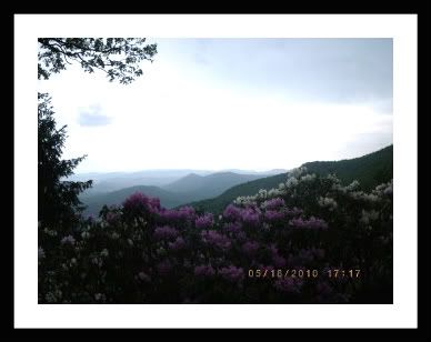
The Blue Ridge
Mountains, like the rest of the Appalachians, were originally
formed by the massive forces that resulted when the continental
plates of Africa and North America collied some 250 million years
ago. The 
 amount of pressure and
heat generated by these two continents crunching together was
tremendous, and as the ancestral Blue Ridge region was uplifted
skyward, layers of rock far beneath the surface became so hot that
they melted. The uplifting, folding and faulting of the mountain
building activities exposed the ancient metamorphosed Blue Ridge
rocks, which are the core of the mountain range. The inner Piedmont
closest to the Blue Ridge is also highly metamorphosed, having been
nearly at the center of the continental collisions. The outer
Piedmont is more variably metamorphosed. The border between the
Blue Ridge and Piedmont provinces is often considered the Brevard
Fault Zone. The only sedimentary rocks or sediments within the Blue
Ridge and Piedmont region are modern (Quaternary age) deposits from
rivers and streams, and rift basin deposits, which formed during
the Triassic and Jurassic periods when the ancient supercontinent
of Pangea split apart. Over time, as the collision forces slowley
subsided, certain melted rocks cooled and crystallized to form
granite. Volcanic and sedimentary rocks were transformed by the
heat and pressure into different types of rock known as schists and
gneiss (pronounced "nice") is two common forms of these metamorphic
rocks. These rocks have tiny, black, shiny specks embeded in them.
These specks are particles of Biotite, a black colored form of
mica.
amount of pressure and
heat generated by these two continents crunching together was
tremendous, and as the ancestral Blue Ridge region was uplifted
skyward, layers of rock far beneath the surface became so hot that
they melted. The uplifting, folding and faulting of the mountain
building activities exposed the ancient metamorphosed Blue Ridge
rocks, which are the core of the mountain range. The inner Piedmont
closest to the Blue Ridge is also highly metamorphosed, having been
nearly at the center of the continental collisions. The outer
Piedmont is more variably metamorphosed. The border between the
Blue Ridge and Piedmont provinces is often considered the Brevard
Fault Zone. The only sedimentary rocks or sediments within the Blue
Ridge and Piedmont region are modern (Quaternary age) deposits from
rivers and streams, and rift basin deposits, which formed during
the Triassic and Jurassic periods when the ancient supercontinent
of Pangea split apart. Over time, as the collision forces slowley
subsided, certain melted rocks cooled and crystallized to form
granite. Volcanic and sedimentary rocks were transformed by the
heat and pressure into different types of rock known as schists and
gneiss (pronounced "nice") is two common forms of these metamorphic
rocks. These rocks have tiny, black, shiny specks embeded in them.
These specks are particles of Biotite, a black colored form of
mica.
A few examples of
Metamorphic Rocks:
When these mountains were originally formed the height of
the Blue Ridge range rose five to ten miles above the earths
surface, towering over the present day Rockies and Himalayans. The
rocks visible to you now were once hidden far below the earth's
surface. The rounded and time-worn knobs of the Blue Ridge, along
 with the other ranges
of the Appalachains, are some of the very oldest mountains in the
world. Continuous erosion over millions of years has weathered away
overlying layers until finally exposing the outcrops you see today.
Other North American ranges are much younger, and they look like
it. The Rocky Mountains, for instance, are only about 65 milloin
years old. They're still quite high and they retain the sharp,
jagged contours of a relatively young range. Slopes of the Blue
Ridge Mountains facing the coastal piedmont are generally steeper
and more rugged than those facing the interior of the United
States. Rocks from the eastern slope are among the oldest on earth,
some exceeding 1.2 billion years and pre-dating the formation of
the mountains. These mountains were formed in three major uplift
phases, the first about a billion years ago, the second perhaps
some 550 million years ago, and the final one about 300 million
years ago. Other uplifts that were regional in nature occurred as
well. Since that time water, wind, temperature and gravity have
caused the fundamental erosion that created the Blue Ridge.
Eventually, however, the Rockies. like the Appalachains, will
succumb to the unrelenting effects of wind and water erosion. It's
just a matter of time.
with the other ranges
of the Appalachains, are some of the very oldest mountains in the
world. Continuous erosion over millions of years has weathered away
overlying layers until finally exposing the outcrops you see today.
Other North American ranges are much younger, and they look like
it. The Rocky Mountains, for instance, are only about 65 milloin
years old. They're still quite high and they retain the sharp,
jagged contours of a relatively young range. Slopes of the Blue
Ridge Mountains facing the coastal piedmont are generally steeper
and more rugged than those facing the interior of the United
States. Rocks from the eastern slope are among the oldest on earth,
some exceeding 1.2 billion years and pre-dating the formation of
the mountains. These mountains were formed in three major uplift
phases, the first about a billion years ago, the second perhaps
some 550 million years ago, and the final one about 300 million
years ago. Other uplifts that were regional in nature occurred as
well. Since that time water, wind, temperature and gravity have
caused the fundamental erosion that created the Blue Ridge.
Eventually, however, the Rockies. like the Appalachains, will
succumb to the unrelenting effects of wind and water erosion. It's
just a matter of time.
An interesting relationship exists between the forces of
nature trying to further strip the soil and the mountains
themselves. Water, in the form of rain, is the most effective agent
of erosion. The five to eight feet of yearly rainfall the area sees
would move much of the mountains to the plains of southeast
Georgia. However, about 2 million years ago, thanks to the same
rain that was so effectively washing the mountains to the sea, a
forest arose. Holding the meager topsoil to the earth, the trees
stopped the massive erosion and a balanced formed. Water that would
erode the mountain now nourished the trees that protected the
topsoil. Without the rainfall the forest would die. Without the
forest, the mountains would die.
Geology:
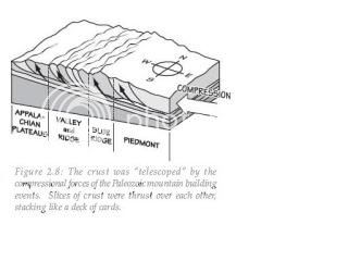
A look at rocks exposed in today's Appalachian
mountains reveals elongated
belts of folded and thrust faulted marine sedimentary rocks,
volcanic rocks and slivers of ancient ocean floor, which provides
strong evidence that these rocks were deformed during plate
collision. The birth of the Appalachian ranges, some 480 million
years ago, marks the first of several mountain building plate
collisions that culminated in the construction of the
supercontinent Pangaea with the Appalachians near the center.
Because North America and Africa were connected, the Appalachians
formed part of the same mountain chain as the Anti-Atlas in
Morocco. This mountain range, known as the Central Pangean
Mountains, extended into Scotland, from the North America/Europe
collision.
reveals elongated
belts of folded and thrust faulted marine sedimentary rocks,
volcanic rocks and slivers of ancient ocean floor, which provides
strong evidence that these rocks were deformed during plate
collision. The birth of the Appalachian ranges, some 480 million
years ago, marks the first of several mountain building plate
collisions that culminated in the construction of the
supercontinent Pangaea with the Appalachians near the center.
Because North America and Africa were connected, the Appalachians
formed part of the same mountain chain as the Anti-Atlas in
Morocco. This mountain range, known as the Central Pangean
Mountains, extended into Scotland, from the North America/Europe
collision.
During the middle Ordovician Period (about 496-440
million years ago), a change in plate motions set the stage for the
first Paleozoic mountain building event (Taconic orogeny) in North
America. The once-quiet Appalachian passive margin changed to a
very active plate boundary when a neighboring oceanic plate, the
Iapetus, collided with and began sinking beneath the North American
craton. With the birth of this new subduction zone, the early
Appalachians were born. Along the continental margin, volcanoes
grew, coincident with the initiation of subduction. Thrust faulting
uplifted and warped older sedimentary rock laid down on the passive
margin. As mountains rose, erosion began to wear them down. Streams
carried rock debris down slope to be deposited in nearby lowlands.
The Taconic Orogeny was just the first of a series of mountain
building plate collisions that contributed to the formation of the
Appalachians, culminating in the collision of North America and
Africa.
By the end of the Mesozoic era, the Appalachian Mountains
had been eroded to an almost flat plain. It was not until the
region was uplifted during the Cenozoic Era that the distinctive
topography of the present formed. Uplift rejuvenated the streams,
which rapidly responded by cutting downward into the ancient
bedrock. Some streams flowed along weak layers that define the
folds and faults created many millions of years earlier. Other
streams downcut so rapidly that they cut right across the resistant
folded rocks of the mountain core, carving canyons across rock
layers and geologic structures.
Culture:
Part of the region we call "Appalachia," the Blue Ridge
Mountains have a rich cultural heritage that it shares not with
individual states, but with other mountain areas in the this
country within a country. Today the individual culture of
Appalachia no longer exists, but has become part of our society in
the form of both country and bluegrass music, "southern" rock and
roll and the many varieties of folk art.
In Georgia, Appalachia's cultural works include the
Foxfire Books, bluegrass music, the rich folk art of the mountains,
and poetry. Foxfire is both a magazine and series of books
published by students from northeast Georgia that chronicle the
lives of the people of Appalachia and the Blue Ridge Mountains.
Black Rock Mountain State Park has a great exhibit in the visitors
center well as the Foxfire Museum on the way into the
park.
Bluegrass music, sometimes called "old-time music" is a
unique sound that had its earliest roots in post-Civil War
Appalachia. It features mostly acoustical instruments and combines
elements of both traditional Scottish and Irish folk music. Song
lyrics, if they are present, can run the gamut from Christian to
stories about life in this mostly rural area.
By the 1880's, loose knit
"fiddlers conventions" were held throughout the region, normally in
a large town near the mountains. Fiddlers would compete for small
prizes and bragging rights. With the advent of radio the musical
genre went commercial, thanks to men like Georgian Fiddlin' John
Carson, the first commercially successful country performer.
Carson, who was born in Acworth, Georgia and grew up in Marietta,
fabricated a birthplace of Blue Ridge, Georgia and a birth date of
1868, so that he would appear older and more rural to his core
constituency. It is from performers like Fiddlin' John that modern
country music evolved.
Traditional folk arts were
also an important expression. Storytelling, folk dancing plus a
wide range of handcrafting are additional outlets for creativity
among the mountain folk. The poetry of the region includes
Georgia's poet laureate, Byron Herbert Reece, who was born in Towns
County, Georgia.
Regional
History:
* Hernando deSoto was the
first European to reach the Blue Ridge Mountains, visiting the
Nachoochee Valley and a site near Carters Lake. The route he took
between these locations is a hotly argued topic. Other Spanish
explorers made it to Georgia's Blue Ridge Mountains as well - as
did some Spanish gold miners who knew of the wealth of the these
mountains.
* First of many English
explorers to enter the Southern Blue Ridge Mountains may have been
Col. George Chicken in 1702 (or earlier). Working for South
Carolina Governor James Moore, Chicken established relations with
many of the Overhill villages in present-day Georgia, North
Carolina and Tennessee including the villages of Chote and
Nachoochee on the northern end of the Chattahoochee River in the
Nachoochee Valley of White County. Most famous of the early
explorers was William Bartram, who walked through Georgia's Blue
Ridge in 1775. He frequently referred to them as the Cherokee
Mountains, because of the large number of Indian villages he
found.
* England's King George III
included the Blue Ridge Mountains as part of the American colonies
when he defined the western extreme of British occupation in
Southeast in 1763 (Proclamation of 1763). At the time, virtually
the entire range in Georgia was considered to be Cherokee land. The
Cherokee farmed the valleys and hunted in the mountains, and called
it "The Enchanted Land." They would continue to live in the Blue
Ridge Mountains until they were forced west on the tragedy known as
the Trail Of Tears.
* Establishing a through
route from Savannah to Knoxville was important to the coastal
traders. From the navigable end of the Toccoa River (at Travelers
Rest), the Unicoi Turnpike ran to Knoxville across the Blue Ridge.
It was the first road to cross the mountains in Georgia. Others
followed including the Union Turnpike (later called the Logan
Turnpike) and the Georgia Road (called the Federal Highway after
1819).
* Georgia gave away land in
the Blue Ridge Mountains in a series of land lotteries and the gold
lottery. Much of the high mountain land was undesirable and winners
sold it to settlers from other areas of Southern Appalachia. These
men and women eagerly moved into north Georgia when the Cherokee
left, and Georgia's Blue Ridge quickly became an extension of
Appalachia. Settled mostly by poor Scottish and Irish immigrants,
Southern Appalachia developed its own language, customs and music
that differed from the culture developed in the United States as a
whole.
* Sparsely populated at the
start of The Civil War, the mountain communities tended to be
pro-union until the outbreak of war. Once Georgia seceded, the
mountain families remained loyal to their state, in spite of the
fact that most did not own slaves. With fathers and older sons off
fighting the war, near anarchy conditions made life difficult for
those left behind to tend farms. Georgia Governor Joe Brown, who
was born and raised in the Blue Ridge Mountains, would send troops
on occasion to restore order.
* After the Civil War the
agricultural economic base was extended with additional businesses.
Mining, especially copper and carborundum was making money, thanks
in part to new railroads running near and through these North
Georgia's mountains. Travel to remote destinations became more
popular, with Tallulah Gorge one of the major attractions. Another
business popular in the mountains was distilling. Moonshine from
the northern tier of counties found its way to the thirsty mouths
of Atlanta from the 1880's on. Large-scale operations were found in
the mountains into the 21st century.
* Beginning in 1900 large
areas of the abundant North Georgia forests were stripped of trees.
Major logging operations were centered near Ellijay, Helen and
Dahlonega, with smaller saw mills pulling trees from almost the all
of north Georgia. The federal government purchased the barren land,
forming the Cherokee National Forest. In 1937 the national forests
were organized along state boundaries, so the Georgia portion of
the Cherokee National Forest was renamed the Chattahoochee National
Forest.
* Power was essential to a
growing city like Atlanta, and Georgia's Blue Ridge Mountains were
the perfect location for hydro-electric generation. In 1912 the
first major power project got underway at Tallulah Gorge. All the
power went to Atlanta; workers on the project went home to candles
and wood-burning stoves. Electricity (and phones) did not become
common in Georgia's Blue Ridge Mountains until after World War
II.
* Long distance rail
carriers avoided the mountains prior to the 1880's -- they made it
much more difficult to make a profit. Not that it hadn't been
tried. In Warwoman Dell there are the graded remains of a railroad
sometimes called the "Blue Ridge Railroad." The project entailed
connecting existing lines from Knoxville to Cincinnati and
Charleston to Andersonville with track across the Blue Ridge
Mountains called the Cincinnati, Louisville, and Charleston
Railroad. Work began in 1854. The state of Georgia proposed and
chartered the "North Eastern Railway" connecting Athens, Georgia
with the as yet unbuilt line. The Civil War interrupted
construction and when it began again after the war money issues
stopped it again. The first railroad to breach the Georgia Blue
Ridge Mountains was the Marietta and North Georgia, from Marietta
to Knoxville. To the east, the Tallulah Falls Railroad purchased an
existing line between Cornelia and Tallulah Falls, extending it to
Franklin, North Carolina.
* County, state and federal
road building projects began in these mountain communities in the
1920's. County roads and most state roads remained gravel into the
1960's, but the federal government began to build paved
"farm-to-market" roads like U. S. 76 in the 1930's. With the roads
came a second wave of economic diversity that stabilized the
agrarian economy. Gas stations, auto repair shops and in some
towns, car dealers - mostly as an addition to the local hardware
store - energized local economies. As the fingers of the interstate
highway system reached towards the mountains in the early 1980's,
Georgia built the Appalachian Development Highway (GA 515 or "the
four-lane").
There is so much
to see and explore here, please take time to absorb your atmosphere
and learn just a small part of this wonderful spot. Start by
getting familiar with the information above and the questions
listed below. Hope you enjoy! Don't forget to check out the FoxFire
Museum.