Geolehrpfad "Tschirgantmassiv" Teil 2 - Mid Level EarthCache
Geolehrpfad "Tschirgantmassiv" Teil 2 - Mid Level
-
Difficulty:
-

-
Terrain:
-
Size:  (other)
Please note Use of geocaching.com services is subject to the terms and conditions
in our disclaimer.

Teil 2
Vulkanismus, Riffbildung und Erze im Tschirgantmassiv
Der Lehrpfad ist so angelegt, dass er durch das geologische Kerngebiet des im Inntal markant aufragenden Tschirgantmassivs führt. Er Verfolgt das Ziel den interessierten Besucher die geologische Entwicklung, der in diesem Abschnitt zu durchwandernden Schichtfolgen näher zu bringen. In den Lehrtafeln werden die Gesteine und ihre Entstehung in farbigen Bildern dargestelt und erläutert. Die Gesteine entlang der Lehrpfad-Route sind ausschliesslich solche, die aus Meeresablagerungen hervorgegangen sind und erst im Zuge jener Gebirgsbildung,in der die Alpen entstanden, ferntransportiert, übereinandergeschoben, gefaltet und schließlich hochgewölbt wurden. Sie sind Teil der nördlichen Kalkalpen, die sich von Vorarlberg bis in die Umgebung von Wien erstrecken.
Beantworte folgende Fragen:
1. An den Startkoordinaten dieses Caches findest Du eine Tafel. Sie zeigt Dir in paar Dinge aus der Vulkanologie im Tschirgantmassiv.
Besondere Ausbildungstypen von vulkanischen Gesteinen sind z.B. Basaltsäulen und erstarrte Polsterlaven. Welcher Typ wird hier noch gezeigt (Einzahl)?
AAAAAAAAAAAA
2. An den Koordinaten:
N 47° 14.309 E 10° 45.796
erfahrt Ihr etwas zur Entstehung von Riffen (Tafel und Aufschluß).Welche Organismen haben zum Aufbau von Riffen beigetragen (lat., Einzahl!!!)? (dritter Organimus, rote Schrift)
BBBBBBB
3. An der Position:
N 47° 14.486 E 10° 45.926
findet Ihr eine Tafel und einen Aufschluß. Schaut Euch hierzu das Spoilerbild an. Um was handelt es sich bei dem rot markierten Bereich?
CCCCCCCCC
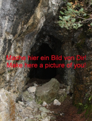
Optional mache hier zusätzlich noch ein Foto von Dir bei den Koordinaten:
N 47° 14.482 E 10° 45.895 und stelle es bitte mit in den Log. (eine Taschenlampe führt Dich hier in interessante Bereiche)
Bilde Dir nun eine Emailadresse nach folgendem Schema:
AAAAAAAAAAAAA.BBBBBBB.CCCCCCCCC@gmail.com
Wer möchte kann nun noch zur Karröster Alm aufsteigen und dort eine kleine Rast einlegen. Anschließend kommt Ihr entweder den gleichen Weg oder über den Rundweg zurück zum Auto.
Zeitumfang: ca. 4-5 Stunden
Strecke: etwa10 km
Viel Spass.
hy_koo
*Gemäß der neuen Richtlinien von Earthcache.org sowie Geocaching.com muss nach dem Besuch eines Earthcaches und der Absendung der Antworten nicht mehr auf eine Logfreigabe gewartet werden. Dies will ich ebenfalls umsetzen. Die meisten meiner Earthcaches verwenden sogenannte Autoresponder. Diese dienen euch als Kontrolle, ob ihr genau die Antworten getroffen habt und werden direkt an die unten stehende Adresse weitergeleitet. Ihr erhaltet also direkt nach der Absendung eine Bestätigung, dass die Antworten richtig sind. Natürlich führen damit kleinere Fehler, die aber den Lernwert des Earthcaches nicht ausschliessen, zu keiner Antwort. In diesem Fall sendet eine Nachricht an mich. Sollten dann die Antworten garnicht stimmen, melde ich mich bei euch. Ansonsten hoffe ich, ihr hattet viel Spaß mit dem Earthcache und konntet etwas für euch entdecken.

Part 2
Volcanism, formation of rocks and ores in massif of Tschirgant
The trail is designed so that it through the geologic core of the emergent Inntal markedly massif of "Tschirgant" leads. He aims to show how the geological development, in this section walking Layers effects to you. In teaching, the rocks and their formation in colored images show and explained. The rocks along the trail route are solely those of the marine deposits are formed and only The course of that mountain-building, in the Alps emerged transported, pushed on top of each other, folded, and finally were high arched. They are part of the Northern Limestone Alps, from Vorarlberg to the outskirts of Vienna cover.
Answer the following questions to the following coordinates:
1. At the start coordinates of this cache, you will find a table. It shows you in some things from the volcanology in Tschirgantmassiv.
Special training the types of volcanic rocks include Basalt columns and froze Polsterlaven. Which type is shown here (singular)?
AAAAAAAAAAAA
2. At the coordinates:
N 47 ° 14,309 E 10 ° 45,796
You learn something about the formation of reefs (table and digestion). Which organisms have to build reefs contributed (Latin, singular!!!)? (third Organimus, red font)
BBBBBBB
3. At the position:
N 47 ° 14,486 E 10 ° 45,926
you'll find a table and a description. Have a look at this, the spoiler picture. What is in the red marked area?
CCCCCCCCC
Optional make this addition to a photo of yourself at the coordinates:
N 47 ° 14,482 E 10 ° 45,895 and make it with the log (a flashlight to get here in interesting areas)
Make you now an email address as follows:
AAAAAAAAAAAAA.BBBBBBB.CCCCCCCCC@gmail.com
Who can now ascend to Karröster Alm" and then a little rest. Then comes your way, either the same or on the circuit back to the car.
Time scale: 4-5 hours
Itinerary: about 10 km
Have fun.
hy_koo
* According to the new guidelines of Geocaching.com and Earthcache.org,after visiting a EarthCaches and the dispatch of the answers must no longer wait for a permission to log. We intend to implement as well. All our so-called EarthCaches use autoresponders. These serve as a check you know if you've hit exactly the answers and are sent directly to the address below. You gain so directly after sending a confirmation that the answers are correct. Of course, this cause minor errors that do not exclude the learning value of the Earthcache to reply. In this case send an message to me. Should then agree not at all the answers, I will contact you. Otherwise, I hope you had fun with the Earthcache and could find something for you.
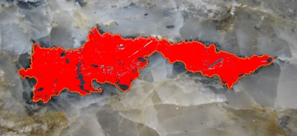
Spoilerbild Stage 3
Additional Hints
(No hints available.)