Bay of Islands 🇦🇺 EarthCache
-
Difficulty:
-

-
Terrain:
-

Size:  (other)
Please note Use of geocaching.com services is subject to the terms and conditions
in our disclaimer.
Bay of Islands belongs amongst Bay of Martyrs, Three Mile Beach and Childers Cave to the Bay of Island Coastal Park. The Bay of Islands Coastal Park is a 32 kilometres (20 mi) long coastal reserve located in Victoria, Australia on the Great Ocean Road between Peterborough and Warrnambool.
Birth of a bay
The great sweep of the bay has been cut by southern ocean swells… over thousands oy years.
The limestone that once extended through the area of the bay was weakened by water seeping through „sinkholes“ – water-filled swampy depressions in the surface clay.
The promontory on this waypoint has not been subject to this seepage, so the limestone is tougher and more able to withstand the battering of storm-whipped waves.
Aboriginal people, for many thousands of years, have feasted on waterbirds and other food from these swamps.
Traces of Kirrae Whurrung living areas, or middens, are hidden in the clay near the tops oft he cliffs. Middens can contain collections of shells, bones, stone fragments and the remains of fire places.
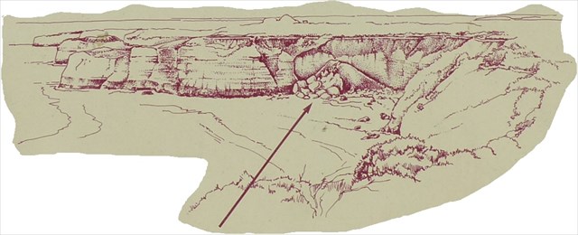
Each time a land-slip occurs, a piece of history is likely to be reveated.
Nibbling Away – a never ending process
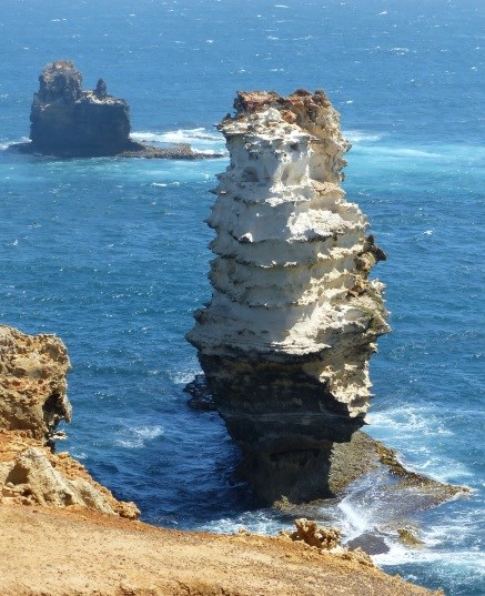
New monuments or rockstacks continue to be slowly created and reclaimed by the Southern Ocean.
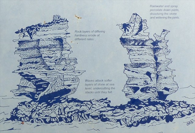
The soft limestone rock of this coast began forming about 10 to 20 million years ago (the Miocene Period), when this coastline was under the sea. Skeletal remains of marine animals, mostly shellfish and calcium rich algae, gathered and were eventually compressed by their weight to from rock layers of differing hardness.
As the sea retreated, the rock cracked in a chequerboard pattern, leaving deep vertical joints. At the end oft he last Ice Age (the Pliocene Period) the sea advanced again, reaching ist present level around 6.000 years ago.
Cliffs are formed when the sea undercuts the edge oft he land, causing it to collapse. Harder blocks remain as stacks while the coast continues to erode away.
Questions:
1) How many distinct layers of rock make up the cliffs around the bay? How did these layers form?
2) When did the landslip that dropped many tonnes of limestone into the sea happen (arrow)?
3) Estimate the rate at which the coastline continues to retreat? Why do some areas wear slower than others?
4) Estimate the height of the rock directly in front of waypoint 2 (see photo in cache description). Is this the tallest rock you can see?
Additional Hints
(No hints available.)
Treasures
You'll collect a digital Treasure from one of these collections when you find and log this geocache:

Loading Treasures