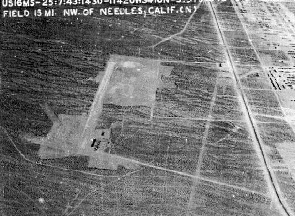
Camp Ibis
Airfield 1943
Park at
the Camp Ibis Marker, (N34‘58.172 W114‘49.977). It's a short
4/10ths hike to the cache. No 4x4's allowed West of CA 95, please.
Easy hike!The Army Corps Of Engineers History of Camp Ibis includes
no mention of the airfield. The dates of construction &
closure, and other specific history of the airfield are unknown
(Quote from link at
http://www.airfields-freeman.com/CA/Airfields_CA_SanBernardino_SE.htm)
I have been exploring the Camp Ibis area for a few years and
there’s just not a lot left to see. It still amazes me that an area
that was inhabited by thousands of young men and women preparing
for combat during WWII, has been all but totally reclaimed by the
desert. It would be likely that General Patton flew to this
airfield often to oversee the training of his troops. The cache is
placed near the only area within the “outline” of the airfield that
still shows evidence of what was there 65 years ago. Organized rows
of rocks forming paths between field buildings, now "long-gone".
About 3/10ths of a mile W/NW from the Official Camp Ibis marker,
you'll notice a change in the desert brush. It becomes smaller and
is a lighter color than the surrounding flora. You can actually see
the outline of the cleared airfield area. The SAT view on the
“Geocaching.com Google Map” link on this info page, clearly shows
this outline. The cache is near the “Rock Paths” which is approx.
4/10ths of a mile from the “Marker”. See if you can venture a guess
as to what the “Crank Shaft” located at N34’58.215 W114’50.405 was
used on. A Tank or Plane or large truck? Definitely not a ’44 Chevy
or Ford! (Thank's to the Pirate's for identifying the "shaft").
Filled with usual fun stuff and a FTF Fiver aka
DCF.