To claim and log this Earth Cache you need to e-mail the answers via our Geocaching profile.
1. What does the oldest group of rocks consist of and what is the oldest group in this area?
2. At GZ if you look up the slope - you should see distinct layers moving upwards from bottom in the grassy slope - then a harder rock towards the top of the mountain. Describe these rocks and indicate what groups or types of rocks you think they are.
3. Estimate the angle of the slope above you at GZ?
4. What was made famous by Charles Darwin in relation with Table Mountain and in what year? - Also look at GC1CEGM
5. Uploading photos to the cache page is the best way to say thank you to the cache developer and to encourage others to visit the location but is only optional.
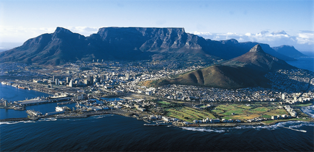
An appreciation of the magnificent sea and mountain views of the "fairest cape" can be enriched by knowledge of its geological foundations. You need not be a geologist to recognise the layers of hard sandstone forming the steeper cliffs, or the crevices and forested ravines etched out by erosion along fractures and faults, or the rounded boulders of the crystalline granite basement exposed by wave erosion along the shoreline.
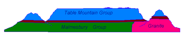
The late-Precambrian age Malmesbury Group is the oldest rock formation in the area, consisting of alternating layers of dark grey fine-grained greywacke sandstone and slate, seen along the rocky Sea Point and Bloubergstrand shorelines. These sediments were originally deposited on an ancient continental slope by submarine slumping and turbidity currents. The sequence was subsequently metamorphosed by heat and pressure and folded tightly in a NW direction so that the rock layers are now almost vertical. Many tall buildings in the Cape Town CBD are founded on these rocks which were in most places, scoured by wave action during past periods of higher sea level.
The Peninsula Granite is a huge batholith that was intruded into the Malmesbury Group about 630 million years ago as molten rock (magma) and crystallized deep in the earth, but has since then been exposed by prolonged erosion. The characteristic spheroidal shapes of granite boulders are a result of preferential weathering along intersecting fractures and are well displayed around Llandudno and Simonstown. Close up, the granite is a coarse-grained rock consisting of large (2-5cm) white or pink feldspar crystals, glassy brown quartz and flakes of black mica containing inclusions (xenoliths) of dark Malmesbury hornfels. In some places, intense weathering has altered the granite to kaolin clay soils that cause slope stability problems in road cuttings. High quality kaolin is mined near Fish Hoek and Noordhoek.
The contact zone where the Malmesbury Group was intruded by molten granite can be seen at Sea Point and was made famous by Charles Darwin during his voyage of scientific discovery on H.M.S. Beagle in 1844. Here, slivers of dark coloured Malmesbury rocks, altered by intense heat are intermingled and folded with the pale coloured intrusive granite to form a complex mixed rock (migmatite) . Large feldspar crystals occur in both the granite and dark hornfels layers.
Though initially intruded at great depth, prolonged erosion eventually exposed the granite at surface and it now forms a basement upon which younger sedimentary rocks of the Table Mountain Group were deposited.
Table Mountain Group sandstones were deposited on this eroded surface of granite basement, in the stream channels and tidal flats of a coastal plain and delta environment that extended across the region about 450 million years ago. The spectacular Chapman's Peak roadway has been constructed along the contact unconformity between granite and the overlying Table Mountain sequence. The sand, silt and mud deposits were lithified by pressure and then folded in the Cape Fold Belt, extending along the southern coast.
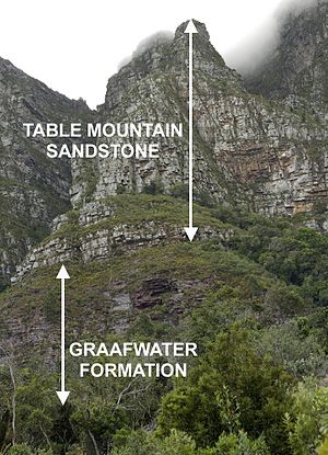
The basal Graafwater Formation (300-450 m thick) consists of interlayered pale brown sandstone, laminated pink siltstone and dark maroon coloured shale. It is best seen in road cuttings on the slopes of Table Mountain and along Chapmans Peak drive. Closer examination shows deposition cycles from current-bedded channel sandstones to increasing proportions of fine-grained maroon shales at the top, deposited in flood plains and lagoons.
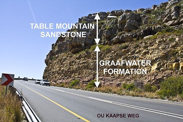
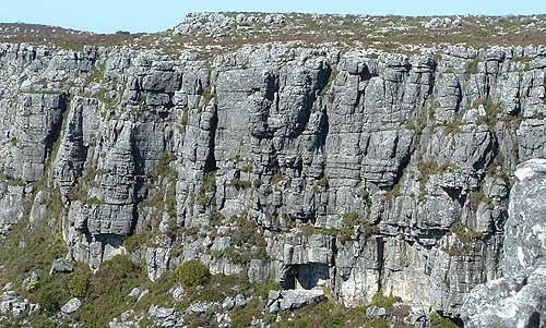
The Peninsula Formation (800-1500 m thick) consisting of hard, light grey coarse pebbly quartz sandstone, dominates the steep mountain cliffs. Current bedding and pebble layers suggest that it was originally deposited as migrating sand bars in broad river channels.
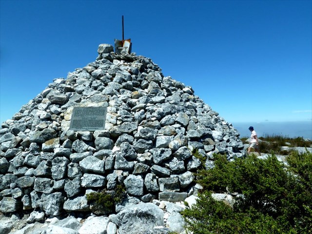
The Pakhuis Formation tillite (a lithified glacial outwash gravel) occurs on the highest points of Table Mountain, such as Maclears Beacon. It contains clusters of angular boulders and pebbles and was deposited at a time when the Gondwana continent, of which Africa is a part, was situated close to the south pole.
Faults cut across and displace the rock layers. These more easily eroded zones are marked by ravines, for instance, cross-cutting faults separate multiple peaks of the Twelve Apostles. Some fault zones of crushed rock (breccia) are re-cemented by dark brown coloured iron and manganese oxide minerals and the Hout Bay museum displays samples of the rich manganese ore that was mined there last century.
The present landscape is due to prolonged erosion having carved out deep valleys, removing parts of the once continuous Table Mountain Group sandstone cover from the Cape Flats and leaving high residual mountain ridges.
References:
http://www.geology.uct.ac.za/cape/town/geology#sthash.WVKp7J8A.dpuf