 counter since oct. 07th 2007
Version francais
au-dessous (pardonnez mon Francais s.v.p.)
English version
below
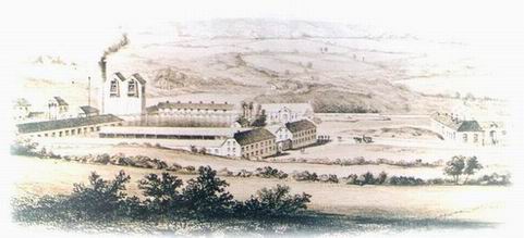
Der Names des Ortes Plombières leitet sich ab
vom französischen Wort "plomb" für Blei. Seit dem 14. Jahrhundert
wurde in der Region um Plombières, Montzen, Hombourg, Mechernich
und Gemmenich Bleierz abgebaut. Der Ort Plombières veränderte sich
in alter Zeit von einem eher unbedeutenden kleinen Weiler in eine
Stätte lebhafter Industrie. Der Erzabbau und die Verhüttung fand
hier im Dreieck zwischen den heutigen Nationalstrassen N608 und
N613 statt. Hier fließt auch das kleine Flüsschen Geul, welches dem
Bergbau immer wieder Probleme durch Wassereinbruch bereitete.
Selbst die Umleitung der Geul durch einen künstlichen Tunnel unter
dem nördlich angrenzenden Steinmassiv war keine Lösung. Zu viel
kleinere Bachläufe und unterirdisch wasserführende Spalten machten
Wassereinbruch zu einem dauerhaften Problem. Dies und auch der in
neuerer Zeit immer unrentablere Bleigewinn führten in den 1920er
Jahren zur Aufgabe der Minen in Plombières. Die Gebäude zerfielen
und die Schächte wurden verfüllt.
Heute ist dieses Gelände zum Teil renaturiert und ein Refugium
für Menschen, Tiere und Pflanzen. Im nördlichen Bereich befindet
sich ein Park mit Grillhütte, in der Mitte ein noch wilder
ursprünglicher Bereich und im Süden ein eingezäunter
Naturschutzbereich. Das ganze Gelände, auch der Naturschutzbereich,
ist öffentlich zugänglich. Naturfreunde werden eine Vielzahl von
Pflanzen finden, die speziell auf bleihaltigen Böden wachsen. An
vielen Stellen sind kleine Informationschilder aufgestellt, die die
Pflanzen benennen. Auch ohne Geocaching ist dieses Gelände einen
Besuch wert und bietet reichlich Fotomotive. Also Fotoapparat nicht
vergessen!
Parken kann man bei N50 44.270 E5 57.630. Hier
steht eine Tafel mit Informationen zur Region und zum alten
Minengelände.
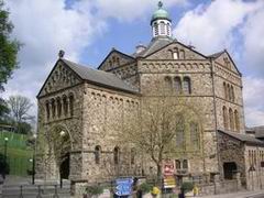
Wpt-1 N50 44.280 E5 57.639: Nahe der schönen Kirche mit
oktonalem Hauptraum steht ein Gedenkobjekt für die
Bergarbeiter.
Frage: Wieviele Jahre bestand die Société? A =
___
Quert die Straße in Richtung Süd-Ost, zweigt in die kleine
Straße ab und folgt den Hinweisschildern "Plombières, Le Site
Calaminaire et son Parc" bis zum
Wpt-2 N50 44.208 E5 57.759: Hier findet ihr eine
Marienfigur und darunter einen lateinischen Spruch in Stein
gemeißelt.
Frage: Wieviele Buchstaben hat der kurze lateinische
Spruch? B = ___
Wpt-3 N50 44.211 E5 57.848: Geht durch den Durchgang
links der Straße, der euch später links am Tor vorbei führt. Der
Weg und das Gelände sind privat aber für Fußgänger offiziell
frei.
Wpt-4 N50 44.245 E5 57.941: Ihr werdet zu einem kleinen
Teich kommen der zum kurzen Verweilen auf Bänken einlädt.
Frage: Wieviele Laternen stehen um den Teich? C =
___
Geht weiter auf die andere Seite des Teiches und rechts an der
Hütte vorbei. Ihr erreicht bald die Stelle, an der die Geul in
einem Felsdurchbruch künstlich umgeleitet wurde.
Folgt zunächst dem Pfad bis zum
Wpt-5 N50 44.249 E5 58.030: Hier beginnt ein schmaler
Trampelpfad steil nach oben bis zur kleinen Straße. Bevor ihr dort
hoch geht, schaut euch einige Meter weiter geradeaus die Stelle an
wo die Geul aus dem Fels tritt. Oben an der kleinen Straße ist
einige Meter weiter der Eingang (zwei blaue Schilder) in das alte
Minengebiet bei
Wpt-6 N50 44.215 E5 58.022: Etwa 15m hinter dem Eingang
biegt ihr links ab und folgt dem Weg bergab bis zur Brücke über die
Geul.
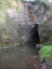
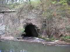
Wpt-7 N50 44.180 E5 58.009: Hier ist die Stelle an der
die Geul in ihrer künstlichen Umleitung im Fels verschwindet.
Frage: Wieviele parallele Schienen verlaufen über die
angestaute Geul (die Schienen tragen jetzt einen Aussichtssteg mit
Bank)? D = ___
Folgt dem Weg in Verlängerung der Brücke und ihr erreicht die
Markierungen zweier ehemaligen Schächte der Minenanlage bei
Wpt-8 N50 44.100 E5 57.968 und Wpt-9 N50 44.082 E5
58.007.
Frage: Die Schächte haben jeweils eine einstellige
Nummer. Addiert die Nummern der beiden Schächte. E = ___
Geht weiter über die alte Minenstraße bis zur Geulbrücke bei
Wpt-10 N50 44.034 E5 58.096: Auf der anderen Seite der
Brücke findet ihr links ein Schild welches die Pflanze dort
benennt.
Frage: Der deutsche Name enthält welches Metall?
Eisen/fer/iron=17, Silber/argent/silver=19, Blei/plomb/lead=21?
F = ___
Geht den Weg links weiter dem Zaun entlang bis zum Eingang in
das Naturschutzgebiet bei
Wpt-11 N50 44.091 E5 58.113: Das Tor kann geöffnet werden
(bitte wieder schließen) und das Betreten des Schutzgebietes ist
erlaubt. Hier genießen Pflanzen und Tiere besonderen Schutz. Bitte
beachtet dies und verhaltet euch entsprechend. Genießt es auf den
Sitzbänken die Natur zu beobachten. Folgt dann dem schmalen Pfad
bis auf den Hügel. Von hier habt ihr einen wunderbaren Blick auf
das Gelände.
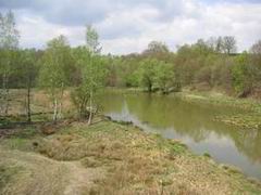
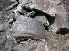
Wpt-12 N50 44.048 E5 58.235: Hier findet ihr viele
Schlackenreste aus den alten Brennöfen. Vielleicht auch einige
Mineralien. Unterhalb des Hügels findet ihr am Ufer des Wasserarms
eine wunderbare Pflanzenwelt.
Wpt-13 N50 44.045 E5 58.258: Ein Schild benennt die
Pflanzen die man oft an Gewässerufern findet.
Frage: Wieviele Buchstaben hat das zweite Wort des
lateinischen Namens? G = ___
Wpt-14 N50 44.011 E5 58.203: Hier verlasst ihr das
Schutzgebiet durch ein kleines Tor (bitte wieder schliessen).
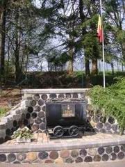
Wpt-15 N50 43.998 E5 58.104: Ein Kreuz errinnert hier an
die Vergänglichkeit des Lebens.
Frage: In welchem Jahr starb Clement? Addiert die 4
Ziffern des Jahres H = ____
So, jetzt habt ihr alle notwendigen Zahlen. Berechnet die
Cachekoordinaten wie folgt
(NEU ab 08.04.2010
!!!):
N50°(2*H+G).(A+B+C+E+F+G+H)
E005°(A-D).(C-E)(2*F+G+H+B)
Version
francais
Le nom de la petite ville Plombières est derivé du mot "plomb".
Depuis le 14iême ciècle on extrait du colombin de la region de
Plombières, Montzen, Hombourg, Mechernich et Gemmenich. Plombières
c'est développé d’un simple hameaux à un lieu industriel
vivant à l'époque. L'exploitation du minerai et le traitement sont
arrivés dans le triangle entre les routes nationales N608 et N613.
Ici aussi coule la petite rivière Gueule qui a causé toujours des
problèmes à l'industrie minière par un effondrement d'eau. Même la
déviation de la Gueule par un tunnel artificiel sous le massif de
pierre au nord n’etait pas une solution. Beaucoup des autres
petites ruisseau et des colonnes sous terre fut un problème
durable. Parce ca et parce que le profit de plomb devenait
récemment de plus en plus non rentable, les mines à Plombières ont
été abandonnées dans les années de 1920. Les bâtiments se sont
désagrégés et ont a remplis les puits.
Aujourd'hui, ce terrain est cultivé en partie et est un refuge
pour l'homme, les animeaux et les plantes. Un parc avec une place
pour fair le barbecue se trouve dans le secteur au nord. Au milieu
un secteur original encore sauvage et dans le sud un secteur de
protection de la nature enfermé. Le terrain entier, aussi le
secteur de protection de la nature, est accessible pour le public.
Les amis de la nature trouveront une multiplicité de plantes qui
s'élèvent spécialement à des sols contenant du plomb. Vous trouvez
des petits plaques avec les noms des plantes. Sans faire le
geocaching aussi, ce terrain vaut une visite et offre beaucoup de
motifs de photo. Ne pas oublier ainsi l'appareil
photographique!
Stationner la voiture est possible à N50 44.270 E5
57.630. Ici vouz trouvez des informations sur la region et la
mine ancienne.
Wpt-1 N50 44.280 E5 57.639: Près de la belle église avec
un interieur oktogonal il y a un object pour souvenir les
mineurs.
Question: Combien des ans existait la Société? A =
___
Traversez la route vers sud-est, prenez la petite route et
continuez à l’indication "Plombières, Le Site Calaminaire et
son Parc" jusqu’au
Wpt-2 N50 44.208 E5 57.759: On y a un figure de Sainte
Marie et au-dessous une courte phrase latin engravé en pièrre.
Question: Combien des lettres compose la courte phrase
latin? B = ___
Wpt-3 N50 44.211 E5 57.848: Prenez le petit passage à
gauche pour passer la porte plus loin à sur la gauche de la route.
Le chemin et le terrain sont privè mais il est loisible aux piétons
pour passer.
Wpt-4 N50 44.245 E5 57.941: Vous arrivez à un étang où
des banques envitent pour se reposer.
Question: Combien des lanternes se trouvent au rond
d’ètang? C = ___
Allez à l’autre coté d’étang et passez l’abri
à droite. Continuez par le sentier jusq’au
Wpt-5 N50 44.249 E5 58.030: Peu après vous allez arriver
au lieu où la Gueule passe la roche par un grotte artificielle.
Ici un sentier entroit monte aux petit route. Avant monter le
sentier n’oubliez pas voir la Gueule qui quitte la grotte
artificielle quelques mètres à l’avant. Sur la route là haut
est l'entrer (deux panneaux bleu) du terrain de la mine
ancienne.
Wpt-6 N50 44.215 E5 58.022: À 15m derrière l’entré
tournez à gauche et descendez le sentier jusqu’au pont sur la
Gueule.
Wpt-7 N50 44.180 E5 58.009: Ici la Gueule afflut dans la
grotte artificielle.
Question: Combien des rails traversent la Gueule arrêtée
(aujourd'hui il y a une passarelle avec un banc sur les rails)?
D = ___
Continuez le sentier en même direction comme le pont et arrivez
au lieu où les deux puit etaient situés à
Wpt-8 N50 44.100 E5 57.968 et Wpt-9 N50 44.082 E5
58.007.
Question: Les deux puits couvertes on des numeros
differentes. Additionnez les deux numeros seules des deux puits.
E = __
Continuez sur l’ancienne route des mineurs jusqu’au
pont sur la Gueule à
Wpt-10 N50 44.034 E5 58.096: À l’autre coté du pont
vous trouvez un signe pour declarer un plant á la gauche.
Question: Le nom allemand comprend un métal. Quel métal
est-ce? Eisen/fer/iron=17, Silber/argent/silver=19,
Blei/plomb/lead=21? F = ___
Continuez le sentier à gauche le long du clôture jusqu’au
entré de la réserve naturelle à
Wpt-11 N50 44.091 E5 58.113: L’accèss à la réserve
naturelle est autorisé. Fermez la porte après s.v.p. Ici les
plantes et les animeaux sont protégées. Respectez-les! Prenez place
sur un banque et savourez la nature. Après continuez le sentier sur
la collune. Vous avez un voir merveilleux sur le terrain.
Wpt-12 N50 44.048 E5 58.235: Sur la collune on trouve des
scories des fours à cuir et peutêtre aussi des minereaux.
Au-dessous de la collune vous trouvez une végétation magnifique aux
bords d’eau.
Wpt-13 N50 44.045 E5 58.258: Un signe attitre les plantes
qui se trouvent souvant aux bords d’eau.
Question: Combien des lettres forme le deuxième mot du
nom latin de la plante? G = ___
Wpt-14 N50 44.011 E5 58.203: Ici on quitte la réserve
naturelle par un porte (fermez le après s.v.p.)
Wpt-15 N50 43.998 E5 58.104: Une croix nous rappele aux
caractère éphémère de la vie.
Question: Clement quittait notre monde dans quel année?
Additionez les 4 chiffre de l’année H = ____
Alors, vous avez tous le nombres maintenant. Calculez les
coordinates de la cache comme si
(NOUVEAU à partir de
08. Avril 2010 !!!):
N50°(2*H+G).(A+B+C+E+F+G+H)
E005°(A-D).(C-E)(2*F+G+H+B)
English
version
The name Plombières is derived from the French word "plomb" for
lead. Since the 14th century people digged for lead ore in the
regions around Plombières, Montzen, Hombourg, Mechernich = and
Gemmenich. The place Plombières changed from a rather insignificant
small village into a place of lively industry in former times.
Digging for ore and smelting took place here in the triangle
between the today's national routes N608 and N613. Here flows the
small river Geul, which again and again caused problems for the
mining industry by intruding water. Even a bypass of the Geul
through an artificial tunnel under the stone massif bordering north
was not a solution. Too many smaller brook runs and underground
water-leading columns caused a durable problem. This and even in
more recent time ever more unprofitable lead gain caused to abandon
the mines of Plombières in the years of 1920. The buildings
collapsed by the years and the pits were filled.
Today this area is partially cultivated and a resort for humans,
animals and plants. In the northern area is a park with a barbecue
hut. In the center still a savage original part and in the south an
enclosed nature protection area. The whole area, also the nature
protection area, is open for public access. Friends of nature will
find a multiplicity of plants, which grow particularly on lead
containing soils. In many places small plates are set up naming the
plants. Also without geocaching this area is worth an attendance
and offers plentifully motives for photoshooting. Thus do not
forget your camera!
Parking is possible at N50 44.270 E5 57.630. Here
you find some informations about the region and the old mining
facility.
Wpt-1 N50 44.280 E5 57.639: Close to the nice church with
has a oktogonal shaped interior you find an object that remembers
the mine workers.
Question: How many years did the Société exist? A =
___
å
Cross the street to south-west, take the small branch and follow
the sign "Plombières, Le Site Calaminaire et son Parc" until
Wpt-2 N50 44.208 E5 57.759: You see a figur of Holy Mary
and underneath a short latin sentence ingraved on a stone.
Question: How many letters has the short latin sentence?
B =___
Wpt-3 N50 44.211 E5 57.848: Take the small passage on the
left side of the road which leads you to pass the gate on the left
side of the road later on. The path and the ground are private but
it’s allowed for pedestrians to pass.
Wpt-4 N50 44.245 E5 57.941: You arrive at a little pond
with benches around to rest for a while.
Question: How many lanterns are around the pond? C
=___
Proceed to the other side of the pond and pass the hut on the
right side. Soon you arrive at the point where the redirected Geul
leaves the artificial tunnel through the rocks.
At first follow the path to
Wpt-5 N50 44.249 E5 58.030: Here starts a small path that
leads uphill to the road. Before going up do not miss to view the
Geul as it leaves the artificial tunnel some meters ahead. At the
road above is the entrance (two blue signs) to the acient mining
area.
Wpt-6 N50 44.215 E5 58.022: About 15m behind the entrance
turn left and follow the path downhill to the bridge across the
Geul.
Wpt-7 N50 44.180 E5 58.009: Here you are where the Geul
enters the artificial tunnel.
Question: How many rails cross the dammed Geul (today
there is a catwalk with a bank mounted on the rails) ? D =
__
Follow the path in the direction as it leaves the bridge and you
will come to the spots where two mining pits were situated. Read
the plates on the concrete covers at
Wpt-8 N50 44.100 E5 57.968 and Wpt-9 N50 44.082 E5
58.007.
Question: The pits are numbered. Add the two one-digit
numbers on both pit covers. E =___
Follow the old mine road until you reach the bridge over the
Geul at
Wpt-10 N50 44.034 E5 58.096: Across the bridge there is a
small sign that names the plant on the left side.
Question: The German name of this plant contains a metal.
Which metal? Eisen/fer/iron=17, Silber/argent/silver=19,
Blei/plomb/lead=21? F =___
Follow the path to the left along the fence until you come to
the entrance of a preserve area at
Wpt-11 N50 44.091 E5 58.113: It’s allowed to enter
the area by the little gate (please close it again). In this area
plants and animals are under protection. Behave appropriate! Take a
seat on the bench and enjoy the nature. After that, follow the
small path to the hill. From here you have great overlooking view
on the area.
Wpt-12 N50 44.048 E5 58.235: Right here you find the
scoria of the kilns and perhaps also some minerals. Down the hill
you see a wonderful vegetation on the waterside.
Wpt-13 N50 44.045 E5 58.258: A sign names the plants that
can often be found on watersides.
Question: The Latin name of the plant has how many
letters in its second word? G =___
Wpt-14 N50 44.011 E5 58.203: Leave the preserve area by
the small gate (please close it again).
Wpt-15 N50 43.998 E5 58.104: A cross remembers the
caducity of life.
Question: In which year died Clement? Add the four
ciphers of the year H =____
Now you have all the numbers. Calculate the coordinates of the
cache as follows
(NEW since April 8th
2010 !!!):
N50°(2*H+G).(A+B+C+E+F+G+H)
E005°(A-D).(C-E)(2*F+G+H+B)