[GQ5] Targu Mures earthcache EarthCache
[GQ5] Targu Mures earthcache
-
Difficulty:
-

-
Terrain:
-

Size:  (not chosen)
Please note Use of geocaching.com services is subject to the terms and conditions
in our disclaimer.
Each place has a story... do you know the story of waters in Targu Mures? Fiecare loc are o poveste... O stiti pe cea a orasului Targu Mures?
Targu Mures is situated in Central area of Transylvania’s plateau, on the Mures river's valley.
Mures River crosses the town from NE to SW. His meadow is 3-4 km wide and is at average altitude of 307 meters. On the city area Mures River has an important confluent, Poclos River. This river also forms a meadow 500 m wide and at average altitude of 310 meters. From the rivers' meadows rises first and second terrace.
This area has plenty of groundwater that it can be seen in Targu Mures and his surroundings. Inside city premises are 5 fresh water springs. At Sângeorgiu de Mureș there are several salty springs.
In the picture bellow it is explained how springs are forming. Non-artesian springs simply flow from a higher elevation through the earth to a lower elevation and exit in the form of a spring, using the ground like a drainage pipe.
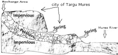
The entire area of Targu Mures has a gravel layer (alluvial sand and boulders) situated between 0 and -10m from ground level. On top of this layer you can found a complex of silty clayey rocks. At the bottom of gravel layer it lays a marly clay base.
In order to log this cache as found you may need:
- Stop Watch Timer/similar application on smartphone
- one bowl/bottle/bucket with known capacity
- altimeter
- to study about spring 
What you need to do?
for the spring on the park of Moldovei Street
1. Compute the volume of the water discharged by the spring (liters/minute)
2. Measure the exact altitude at spring level (meters)
for the spring on the Predeal street (check the waypoint)
3. Compute the volume of the water discharged by the spring (liters/minute)
4. Measure the exact altitude at spring level (meters)
for the next two questions you need to think about what you've just learned:
5. Why do you think the two springs have different flows? Why one of them "has more water"?
6. As stated very clear on the notice board next to both springs, the water must be boiled for 30 minutes before consumption. Please send me your oppinion about why the water is no longer good for drinking.
Send the answers to cache owner (as message in geocaching.com)
Feel free to attach as many photos as you want, but please do not post the answers in your logs or photos.
Targu Mures este situat in partea centrala a podisului Transilvaniei, pe valea raului Mures.
Raul mures strabate orasul pe directia NE-SW. Lunca lui are o latime de 3-4 KM si are o altitudine medie de 307m. In dreptul orasului, Muresul are un afluent important, paraul Poclos. Acest parau are o lunca lata de app 500m si a carei altitudine medie este de 310m. Aria orasului se intinde si pe prima si a doua terasa a Muresului.
Aceasta zona (Targu Mures si imprejurimi) este bogata in ape subterane. In perimetrul orasului exista 5 izvoare. La Sângeorgiu de Mureș exista cateva izvoare sarate.
In imaginea de mai jos este explicat cum se formeaza aceste izvoare. Apa se scurge de la o altitudine mai mare la locul izvorului prin interiorul pamantului folosind pietrisul si subsolul ca o structura de tevi.
Pe toata suprafata orasului exista un substrat de pietris format din nisip aluvionar si bolovani. Acest substrat este situat la adancimi intre 0 si -10m. Deasupra acestui strat exista un complex de roci argiloase prafoase. Dedesuptul stratului de pietris este o baza de argila marnoasa.
Ca sa puteti loga acest cache ca "found" probabil va trebui sa aveti:
- cronometru sau aplicatie similara pe smartphone
- un recipient (sticla, galeata) cu capacitate cunoscuta
- altimetru
- sa studiati despre formarea si functionarea izvoarelor
Ce trebuie sa faceti
pentru izvorul din strada Modovei
1. Calculati debitul izvorului (litri/minut)
2. Masurati altitudinea la care se afla izvorul(metri)
pentru izvorul de pe strada Predeal (verificati waypoint-ul)
3. Calculati debitul izvorului(litri/minut)
4. Masurati altitudinea la care se afla izvorul(metri)
pentru urmatoarele doua intrebari aveti nevoie de cunostintele dobandite anterior
5. De ce considerati ca cele doua izvoare au debit diferit?
6. Dupa cum se mentioneaza pe placile informative de la fata locului, apa trebuie fiarta minim 30 minute inainte de a fi consumata. Va rog trimiteti parerea dumneavoastra legata de motivul pentru care apa nu mai este potabila.
Trimiteti raspunsurile catre cache owner (ca mesaj in geocaching.com)
Puteti atasa orice poze doriti, dar va rog sa nu furnizati imagini sau comentarii/log-uri care contin raspunsul la intrebari.
Additional Hints
(No hints available.)