Alanya Anders..........Also Alanya Multi-cache
B&W.cachers: A lot of things on the route of this hike is been chanched! So it's impossible to find all the coordinates.
Time to archive!!
Alanya Anders..........Also Alanya
-
Difficulty:
-

-
Terrain:
-

Size:  (small)
Please note Use of geocaching.com services is subject to the terms and conditions
in our disclaimer.
We like to show geocachers more than the usual touristic places. Only a few kilometers away from the main road you will find the most beautiful views, historical and culture places and nature spots.
TIP!!
You can do the following caches, GC1ZTAX, GC3K9KA, GC3K9KZ, GC4NV60, GC374Z in one tour, if You do them in the order as herefore.
Near WP 3 You will find the cache Ruins of Hidir Ilyas GC3K9KA
Near WP 5 You will find the cache Hidir Ilyas GC3K9KZ
Between WP5 and WP6 You will find the cache Hills off Alanya,
GC4NV60 Alanya Overview. GC374Z5
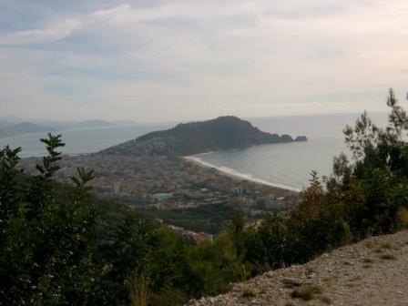
A very nice walk almost downhill at the lower mountains, with magnificent views on the sea, Alanya and the castle.
You will see Alanya in a different way. Enjoy the views, scenery, silence, nature, flowers, herbs and an old Greek Church.
The hike is for people who enjoy walking. The length is about 7,5 km. Put on some good shoes and take enough water with You. There are some places to get fresh and good drinkable water.
To start, you first have to go to the Ataturk Cad. At
WP1 (N36°32.622 E031° 59.931)
you can take the bus (number 5)which goes to TEPE. This bus departs at 07.00, 08.00, 10.00 and 12.00 o'clock.
To start the hike at WP2 you will have to get out of the bus at
WP2 N36° 34.261 E031° 59.336 (HIDIR ILYAS)
Go to WP3 N36° 34.027 E031° 58.708.
At this waypoint write down the number TS'.........................
(first 2 numbers minus next 2 numbers) =....... = G
Proceed to WP4 N36° 34.122 E031°58.664
What is the height at this point?
Between 300 and 350 meters = 1
Between 350 and 400 meters = 2
Between 400 and 450 meters = 3
Between 450 and 500 meters = 4
Answer =.............. = H
Now take the left road and go to WP5 N36° 34.236 E031° 58.531.
From what year does this originates according to the plate? ....... Add up the numbers together= ....... x 3 = ..........=A
How many windows are there = ...... x 4 = ........ = E
How many entries are there? Entries = ........... = F
What is the number on the main entrydoor?.........
First number plus second number = ................= B
After enjoying this place full of culture we go on with our hike to the next waypoint.
WP6 N36° 3F.8G6 E031° A.640 .
Before You get on this waypoint You passed Mehmet Görucu, with 8 figures. Make just one figure of it = .........= D (stack count)
Here you can have a rest and drink some fresh tasty water How many water taps are here? =..............=C
A= ..... B=..... C=..... D=..... E=..... F=..... G=..... H=.....
On WP7 you will find the cache.
WP7 N36°(E-F).(F+C)DG. E031° A.(B-C)H(G-F)
The cache is a small plastic box with a black lid and contains a logbook and NO pencil.
To reach the main road go to the direction Yasirali cadessi and go down to : WP8 N36° 33.411 E031° 58.066 where You can find a bus (every 10 minutes) to get home.
* *We like to thank You, for searching and finding this cache, with a banner so You can pimp up your profile.

![]()
We want You to log in English or German only, so that also everyone can read it.Take a pencil with you!!!
Additional Hints
(Decrypt)
haqre U.Zruzrgyv Pnqrffv