Fife Stop Line - Newburgh Pillbox Traditional Geocache
Fife Stop Line - Newburgh Pillbox
-
Difficulty:
-

-
Terrain:
-
Size:  (micro)
Please note Use of geocaching.com services is subject to the terms and conditions
in our disclaimer.
This cache is one of a series based around the "Fife Stop Line", a
second world war ani-invasion defensive structure built in 1940/41.
With the threat of invasion imminent both coastal and inland
defences were constructed running the length and breadth of the
country and these structures followed geographic features such as
rivers, cliffs, canals, valleys and in this case the
Newburgh-Kircaldy railway line.
All of the caches in this series are located close to surviving
remnants of the Fife Stop Line but today these exist as isolated
structures seemingly dropped at random into the nearest hedgerow
but this is far from the case as these buildings were once
components in a much larger system with each having it's own part
to play.
The purpose of this cache series is to visit these sites and put
them back into context, explaining how they fitted into the overall
defensive scheme. You'll never look at this part of Fife in the
same way again. The purpose of this particular line was two-fold,
firstly to prevent an army which had landed on the East Neuk of
Fife from advancing any further inland and secondly to contain them
in an area where they could be killed.
The area to the east of this line was intended to be one large
killing field. The line was a continuous series of pillboxes,
bunkers, barbed wire, tank traps, minefields and roadblocks
stretching coast to coast from Newburgh in the north to Dysart in
the south. Once in place no person or vehicle could pass through
the line except via official crossing points situated on the major
roads. All of the open fields to the east of the stop line were
mined thus forcing the enemy to use the roads.
The apparent weak points in the system were therefore those
locations where roads crossed over or under the railway line, so
knowing this the military planners prepared a few surprises for any
invader approaching those areas. You will find that all the
structures in this cache series are to be found within 100 metres
of the railway line and are positioned to lay down fire onto the
roads that approach it.
Newburgh is the northernmost limit of the Fife Stop Line because
from here it merged with the Tay estuary coastal defences. There
were however other lines continuing onwards, one went west to
Dunblane and the other north through Perth, Dunkeld and Stanley
before turning west to Ballinluig and Loch Rannoch.
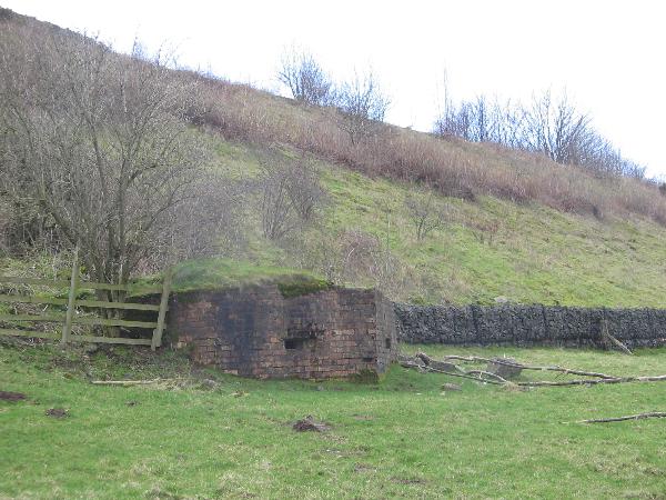
This cache is located at the eastern end of Newburgh by the side of
the the main Perth-Cupar road which was the target of a cunningly
concealed pillbox. Unfortunately the landowner keeps horses in the
field where it is located, so I can't take you up there and you're
going to have to make do with looking at it from the roadside. This
isnt a major problem because the objective of this cache is to show
how the pillbox has been concealed within thelocal terrain. Also
since the entrance to the structure is sealed there's not much up
there that you can't already see from down here. There are however
closeup photographs of the exterior, interior, and the view from
the firing appertures posted on this page.
To find it stand at the cache site with your back to the road and
follow the line of the cemetary wall uphill across the fields to
the point where the steep railway embankment rises upwards. Scan
along the embankment, to your right, looking for the point where
the stone facing gives way to grass... too late, they found you
first.
Original Sources This cache series was insprired by Wallace
Shackleton's "Wee Jaggy bits O'History" website and the "Defence of
Britain" online database at www.britarch.ac.uk, thanks also to
Wallace for telling me where to find "The Deadly Garden".
Additional Hints
(Decrypt)
Penpx arkg gb cvyyne