
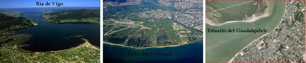
La clasificación más usual de las desembocaduras de los ríos distingue tres tipos principales: rías, estuarios y deltas:
- Las rías son brazos de mar que se internan en la costa, coincidiendo con la desembocadura de un río. Con la marea alta el agua del mar invade la zona de la ría y con la marea baja se retira por lo que la salinidad del agua y las corrientes varían cíclicamente. En la costa gallega tenemos varios ejemplos de rías.
- Un estuario es la parte más ancha y profunda de la desembocadura de un río en el mar, generalmente en zonas donde las mareas tienen amplitud u oscilación. La desembocadura en estuario está formada por un solo brazo ancho. Los estuarios se originan porque la entrada de aguas marinas durante la pleamar retiene las aguas del río, mientras que durante la bajamar, todas las aguas comienzan a entrar a gran velocidad en el mar u océano, lo que contribuye a limpiar y profundizar su cauce, dejando a menudo, grandes zonas de marismas. Una zona de estuarios es el Noroeste de Francia debido a sus mareas de gran amplitud.
- Un delta es un territorio triangular formado en la desembocadura de un río, mediante sedimentos que se depositan formando montículos a medida que la corriente del río va desapareciendo. El río circula por encima de estos montículos convirtiéndolos en islas separadas por brazos fluviales o canales que se van separando y volviendo a juntarse. El suelo de los deltas es generalmente fértil aunque algunas veces tienen un nivel de sal algo elevado. El delta más famoso es el del río Nilo. En Cataluña el mayor es el Delta del Ebro seguido por el Delta del Llobregat.
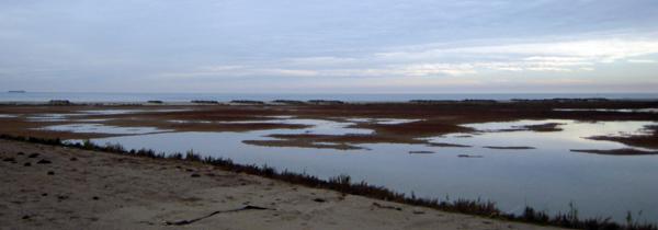
El río Llobregat en su desembocadura forma el Delta del Llobregat, un delta con una superficie de 98 km cuadrados. Es un terreno llano que se inunda con las crecidas del río, siendo por lo tanto una zona pantanosa. Tiene forma redondeada y está considerado de importancia internacional por la Unión Europea, estando catalogado como Reserva Natural. El delta se comenzó a formar hace unos 2.500 millones de años con materiales del Pleistoceno al Holoceno que descansan encima de materiales más antiguos. A lo largo del tiempo se han formado cuatro deltas, de los cuales los tres deltas más antiguos se encuentran en la actualidad debajo del mar aunque antiguamente emergían todos ya que el nivel del mar era mucho más bajo. El delta actual consiste en arenas, gravas y limos que han ido avanzando hacia el mar desde hace aproximadamente 6.000 años. En el techo de las arenas y gravas se dispone un nivel variable de arcillas rojas y grises que corresponden a la llanura deltaica. Geográficamente se pueden diferenciar varias zonas en el delta: desde el mar hacia el interior, pueden distinguirse el sector sumergido de la plataforma continental, la playa arenosa, el pinar costero y el resto del territorio, formado principalmente por cultivos, eriales y zonas urbanizadas, así como humedales donde subsisten algunas lagunas de agua salobre. El Delta es especialmente importante por su diversidad biológica, especialmente las aves. Se conocen 360 especies de aves que utilizan las lagunas para nidificar o como punto de paso en sus migraciones.
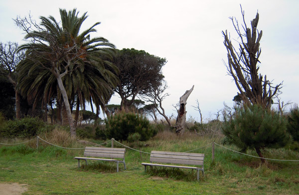
En el interior de la Reserva Natural del Delta del Llobregat hay una serie de itinerarios que recorren el mismo. El acceso es libre y gratuito, los caminos son de tierra y están adaptados para silla de ruedas, y el horario está limitado. A lo largo de los recorridos hay miradores y torres de observación desde donde se pueden observar por un lado la morfología del delta, las lagunas y pantanos, la playa, la desembocadura del río y el mar y por otro su peculiar ecosistema especialmente las aves y demás fauna y vegetación.
Para poder registrar este Earthcache deberéis responder a una serie de preguntas y haceros una foto donde salgáis mostrando el GPS y la desembocadura del río en el punto indicado en la coordenada del cache. El itinerario más recomendable para llegar a este punto es el Itinerario 2-Riu/Pineda de Ca l'Arana/Cal Tet. Es un recorrido de 5,2 km. completamente plano, sin ningún tipo de dificultad y que ofrece una buena visión general de toda la reserva. Para más información como por ejemplo horarios podéis consultar la web oficial (ver más arriba).
1) Nombra un delta de cada uno de estos continentes: Europa, Asia, África, América del Norte y América del Sur
2) ¿Cuáles son las dos lagunas más grandes del delta del Llobregat?
3) ¿En qué año se excavó el estany de Cal Tet?
4) Cita cinco especies de aves que podéis encontrar en el estany de Cal Tet (esta información se puede encontrar en los miradores del estanque)
No es obligatorio pero se agradecerá que posteéis alguna de las fotos que hagáis durante el recorrido.
Enviad las respuestas a : macdigisc(arroba)gmail.com
ENGLISH TRANSLATION
El Delta del Llobregat
The most usual classification of the river mouths distinguishes three principal types: "rías", estuaries and deltas
- The "rias" are arms of sea that enter on the coast, coinciding with the river mouth of a river. With the high tide the water of the sea invades the zone of the "ria" and with the low tide it retires for what the salinity of the water and the currents change cyclically. On the Spanish Galician coast we have several examples of "rias".
- An estuary is the broadest and deep part of the river mouth of a river in the sea, generally in zones where the tides have a big amplitude. The river mouth in estuary is formed by an alone broad arm. The estuaries originate because the entry of marine waters during the tide retains the waters of the river, whereas during the low tide, all the waters begin to enter to great speed in the sea or ocean, which helps to clean and deepen its riverbed, creating often, big zones of marshes. A zone of estuaries is the Northwest of France due to their tides of great extent.
- One delta is a triangular territory formed in the river mouth of a river, by means of sediments that settle forming mounds as the current of the river is disappearing. The river circulates over these mounds turning them into islands separated by fluvial arms or channels that are separating and returning to be joined. The soil of the deltas is generally fertile though often they can have a slightly high level of salt. The most famous delta is that of the river Nile. In Catalonia the major one is the Delta del Ebro followed by the Delta del Llobregat.
The river Llobregat in its river mouth forms the Delta del Llobregat, a delta with a surface of 98 square km. It is a flat area that is flooded by the rises of the river, being therefore a swampy zone. It has rounded form and is considered of international importance by the European Union, being catalogued as Natural Reserve. The delta was begun to form it does approximately 2.500 million years with materials of the Pleistocene to the Holocene that rest on more ancient materials. Throughout the time they have formed four deltas, of which the three more ancient are at present under the sea though formerly they were emerging all since the level of the sea was much lower. Current delta consists of sands, gravels and slimes that have been advancing towards the sea for approximately 6.000 years. In the top of the sands and gravels one arranges a changeable level of red and gray clays that correspond to the deltoid plain. Geographically we can differentiate several zones in the delta: from the sea towards the interior, there can be distinguished the sector plunged of the continental platform, the sandy beach, the coastal pinegrove and the rest of the territory, formed principally by cultives, uncultivated lands and urbanized zones, as well as swamps where there survive some lagoons of salt water. The Delta is specially important for its biological diversity, specially the birds. There are known 360 species of birds that use the lagoons to nest or as point of step in their migrations.
Inside the Natural Reserve of the Delta del Llobregat there are several itineraries that cross it. The access is free, the paths are adapted for chair of wheels, and the visiting hours are limited (see related web page). Along the itineraries there are viewing-points and towers of observation from where we can observe on the one hand the morphology of the delta, the lagoons and marshes, the beach, the river mouth of the river and the sea and for other one its peculiar ecosystem specially the birds and other fauna and vegetation.
To be able to register this Earthcache you will have to answer a series of questions and make a picture of yourself showing the GPS and the river mouth of the river in the point indicated in the coordinate of the cache. The most advisable itinerary to come to this point is the Itinerary 2-Riu/Pineda of Ca l'Arana/Cal Tet. It is a completely flat tour of 5,2 km, without any type of difficulty and that offers a good general view of the whole reserve. For more information as for example visiting hours you can consult the related official web.
1) Name a delta of each one of these continents: Europe, Asia, Africa, North America and South America
2) Name of the two biggest lagoons in the Delta del Llobregat
3) Year of excavation of the Cal Tet lake
4) Name five species of birds that you can find in Cal Tet's laqoon (this information can be found in the viewing-points of the lagoon)
It is not mandatory but appreciated that you post some of the photos that you take during the tour.
You must send the answers to: macdigisc(arroba)gmail.com