Kansas City Floods EarthCache
-
Difficulty:
-

-
Terrain:
-
Size:  (other)
Please note Use of geocaching.com services is subject to the terms and conditions
in our disclaimer.
Floods and Flood Plains
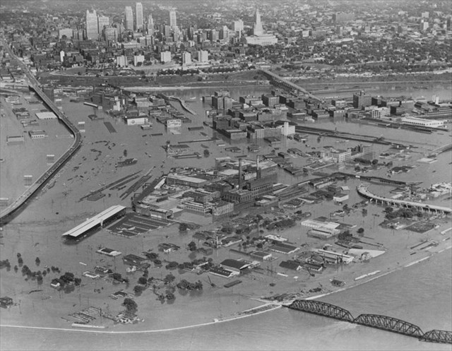
The month of July in the Years 1844, 1951, and 1993 saw floods of epic proportion in Kansas City. Roads, businesses, and homes flooded with widespread damage occuring that ran into the billions of dollars.
This earthcache will take you to a spot along the edge of the Missouri River not far from Downtown and the Spice Market area. This is a very susceptible spot for flooding and is closely watched by local professionals.
Many people believe Kansas to be flat and nothing but farmers' fields. Closer observation shows the many landforms throughout the state. A landform that is readily noticeable as you cross a river is the broad, flat area on one or both sides to the river, called a floodplain.
Flood plains are formed over millenia as the rivers flooded repeatedly from heavy rainfall or melting glaciers, eroding the surrounding area and depositing topsoil from areas up stream. These areas may seem to be stable but in reality are constantly changing. The action of rivers forming and reforming flood plains was highlighted by the "record" floods in Kansas City over the past two centuries.
The listed coordinates will take you to the approximate "high water marks" for the three Great Floods that have struck Kansas City. Yes, if you were standing just to the west of this location a few yards, not just your your feet would be wet. Can you just imagine the volume of water flowing by with the river at this level!!!???
To log this Earthcache, find the answers to the following questions and email your answers to us (woodlandclan@hotmail.com) or via geocaching.com. Be sure to include the title or tagline "KANSAS CITY FLOODS" in your e-mail so that we know to which of our caches you are referring to.
DO NOT POST YOUR ANSWERS IN YOUR LOG, EVEN IF ENCRYPTED.
THE PLAQUES HAVE GONE MISSING, BUT THE INFO CAN BE FOUND VIA GOGGLE.
1.) Provide the following information for all three of the Great Floods of Kansas City (1844, 1951, & 1993): (a) crest date; (b) crest elevation; (c) crest discharge.
2.) Provide the elevation using your GPSr for the sidewalk that you are standing on as you record the requested information for question one.
3.) Using your GPSr, estimate the current water level of the river. HINT: You can use the handy measuring stick engraved in the concrete as you exit the elevator for assistance in calculations.
4.) NOT REQUIRED, BUT STRONGLY SUGGESTED/REQUESTED. Please take a photo of you and your GPSr at the site and upload to the listing. Be sure not to give away any information in your photos for question answers.
Additional Hints
(No hints available.)