Schutz für Langeoog
Auf der Urlaubsinsel Langeoog werden seit Beginn des 20. Jahrhunderts Küstenschutzmaßnahmen durchgeführt, ohne die diese reizvolle Insel in ihrer Existenz gefährdet wäre.
Die Entstehung der Ostfriesischen Inseln nach der Platen-Hypothese von Barckhausen gilt heute als allgemein akzeptiert. Sie besagt, dass durch das Zusammenwirken von Wellen, Wind, Gezeiten und Strömungen zuerst periodisch überflutete Sandplaten aus feinem Sand entstanden, die sich dann über hochwasserfreie Strandwälle bis zum Endstadium dünentragender Inseln entwickelten. Bei Langeoog hat sich der Übergang zu einer hochwasserfreien Plate zwischen 3000 und 2000 J.v.h. vollzogen.
Die seeseitigen Randdünen bilden dabei einen naturgewachsenen Schutzwall vor Sturmfluten. Sie werden deshalb auch Schutzdünen genannt und sind von der Seeseite her wie folgt aufgebaut: Strand, Vordüne, Weiße Düne, Graue Düne, Braune Düne, Dünental.
Da es in der Vergangenheit schon mehrfach zu Einbrüchen kam, müssen diese Schutzdünen selbst besonders geschützt werden. So dürfen auf der gesamten Insel die ausgewiesenen Wege in den Dünen nicht verlassen werden, um eine Schädigung des empfindlichen Dünenbewuchses und damit ein Abtragen des Sandes zu verhindern.
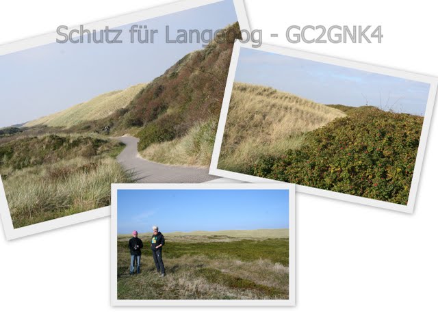
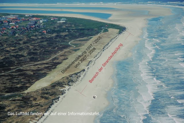
Sandmangel, Erosion und Dünenabbrüche durch Sturmfluten haben besonders auf Höhe des Pirolatals die natürlichen Schutzdünen geschwächt. Eine seit 1997 in mehreren Etappen künstlich angelegte einzigartige Dünenverstärkung auf der Landseite soll hier die Schutzdünen stabilisieren. Sie hebt sich durch ihre Bepflanzung mit Strandhafer sehr deutlich von den ursprünglichen Randdünen ab.

Zusätzlich wurden im Jahr 2010 umfangreiche Strandaufspülungen zur Strandverbreiterung durchgeführt, um den Dünenbereich zu schützen. Der Sand hierfür gelangte durch große Rohrleitungen vom Flinthörn zum Strand vor dem Pirolatal. Es wurden 450.000 m³ Sand auf einer Länge von 2465 m aufgespült.

Um den Cache loggen zu können, löst Aufgabe 1-3 online und begebt euch zur Cache-Koordinate für die Aufgaben 4-5:
1. Woher hat das Pirolatal seinen Namen?
2. Was ist ein "Schlopp"?
3. Wie lauten die drei Fachbegriffe für Vordüne, Weiße Düne und Graue Düne?
4. Ermittelt bei einem Spaziergang durch das Pirolatal die Länge der künstlichen Dünenaufschüttung.
Für den Rückweg bietet sich ein Strandspaziergang an. Die Weglänge durch das Pirolatal und über den Strand zurück beträgt ca. 5 km.
5. Macht optional ein Foto von euch mit GPS-Gerät im Pirolatal bei dem auch die Dünenaufschüttung zu erkennen ist.
Sendet uns eure Antworten per E-Mail über unser Profil, ihr dürft dann direkt loggen. Sollte etwas nicht stimmen, melden wir uns! Das Bild hängt bitte an euren Log. Wir wünschen euch nun viel Spass und einen schönen Aufenthalt in dieser phantastischen Landschaft!
Wir wünschen euch nun viel Spass und einen schönen Aufenthalt auf dieser tollen Insel!
ifindnix
Hier sind tiefer gehende Informationen zu finden.
Protection for Langeoog
Since the beginning of the 20th century the coastline of the holiday island Langeoog is undergoing protective measures, without which the existence of this pretty island would be in danger.
The plate-hypothesis by Barckhausen has generally been accepted as the theory behind the formation of the East Fresian Islands. It implies that due to the cooperation of waves, wind, tides and currents sandplates consisting of fine sand were created, which initially were flooded periodically. Later they were transformed into sand mounds free of water and finally developed into dune carrying islands. In the area of Langeoog this transformation into a flood free plate took place between 3000 and 2000 years ago.
The outer dunes which are facing the sea form a natural protective barrier against storm surges, which is why they are also called protective dunes. They are built as follows, starting from the sea side: beach, predune, white dune, grey dune, brown dune and dune valley
As in the past even these protective dunes have broken down repeatedly, they themselves need special protection now. That is why across the whole island it is not allowed to leave the dedicated paths, in order to avoid damage to the sensitive vegetation, which in turn would cause sand erosion.
Especially around the Pirola valley the lack of sand, erosion and the breaking down of dunes by storm surges have weakened the natural protective dunes.
Here a unique artificial dune enhancement has been built in various stages since 1997 on the land facing side, which is supposed to stabilise the protective dunes. It clearly stands out against the original outer dunes due to its cultivation with beach grass.
In addition extensive build up of sand has been carried out in 2010, in order to widen the beach and protect the dunes. The required sand was delivered through large pipelines from Flinthörn to the beach in front of the Pirola valley. Along the length of 2465 m 450,000 m³ sand were deposited.
To log the Cache go to the Cache coordinate and solve the following tasks:
1. How did the Pirola valley get its name?
2. What is a „Schlopp“?
3. What is the technical term for Predune, White dune and Grey dune?
4. Take a walk through the Pirola valley and find out the length of the artificial dune enhancement.
For your way back choose a walk along the beach, the combined length through the Pirola valley and along the beach is ca. 5 km.
5. Optional: Take a photo of yourselves in the Pirola valley including the GPS and the dune enhancement.
Please send your answers via e-mail using our profile, you can then log directly. If something goes wrong we will contact you. Please attach your photo to your log.
Have fun and enjoy your stay on this lovely island!
ifindnix
FTF - OstfrieseMitGPS (28.11.2010)
STF - AnandAn (31.12.2010)
TTF - SebbiD (31.12.2010)