keçi yolu 1 Traditional Geocache
-
Difficulty:
-

-
Terrain:
-

Size:  (small)
Please note Use of geocaching.com services is subject to the terms and conditions
in our disclaimer.
The intention of this cache is to show you a forgotten trail – a goat path (=keci yolu) between Turunç and Amos. The path runs parallel, but above the road and provides beautiful panoramic views of the bays of Turunç and Marmaris.
If you neither stay in Turunç nor you come by car to Turunç you can reach this village by a dolmus from Marmaris or Içmeler. From the southern end of Turunç (roundabout / petrol station) you have to use the road to Amos for a short distance. Turn right on road 37 Sokak – a dusty road. This is the place to park your car (waypoint 01: parking Turunc). After a few meters follow the road 39 Sokak in left direction. At the end of the road you reach an estate (no 3/5) enclosed by a wall. Follow the wall on the right and you can see two pathes (waypoint 02: fork Turunc). Choose the left one which still takes its course along the wall of the estate. Shortly afterwards you reach the real beginning of the goat path. Its course – follow the red waymarking – is clearly visible along the whole distance.
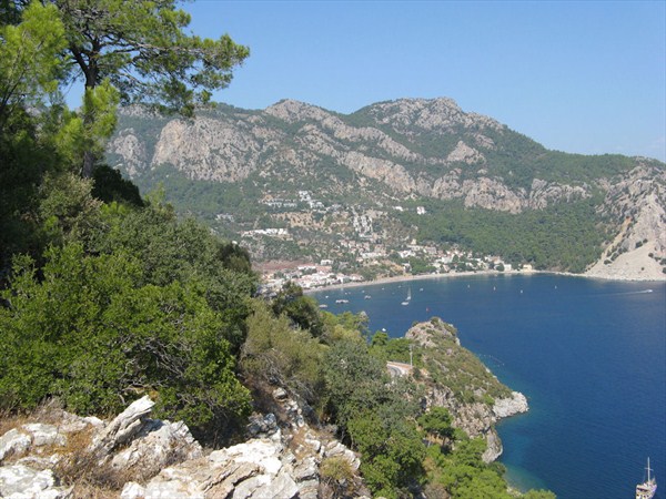
The goat path guides you through a typical forest of pines and also through an area with a lot of laurel. At first you can enjoy beautiful views of the bay of Turunç and later on of Marmaris.
The cache is placed at a wider part of the trail. You look over the bay of Marmaris and you can hear the pumps of the clarification plant. The rock wall is on the right hand of the trail. The cache is placed about 97m above sea level.
The last part of the trail – between cache and road to Amos (waypoint 03: crossing Amos) – has become a little bit overgrown.
When you have reached the road you have the following choices:
- Back to Turunç: Turn left and use the road
- Amos Beach: Turn right on the road until the entrance of Profesörler Sitesi. Go through the complex downwards to Amos Beach (turkish: plaj), follow the signs to Amos Restaurant. During the holiday season you can use the dolmus boat (taxi boat) to Turunç (departure: 5 pm).
- Ancient City Amos: Turn right on the road until you reach the entrance of the ancient city (1km)
The trail is mostly in the shade, but carry enough water on hot weather and don’t forget sun protection. We recommend to wear sturdy shoes and long-sleeved clothing. The path is approx. 2km long, the altitude difference is 110m. It is completely shown in Open Street Maps.
During our absence in Turkey the maintenance of this cache is done by a friend living in Turunç.
update 2023-10-08
Some stones have broken of and therefore the original cache box got lost. poldimir & donfranco were so kind to replace it today. Listing, hint and spoiler pictures were revised.
Additional Hints
(Decrypt)
uvqvat cynpr vf va gur ebpx jnyy va n fznyy avpur
fznyy avpur vf znexrq va yrsg ybjre pbeare bs gur fcbvyre cvpgher