Hockendes Weib - Earthcache


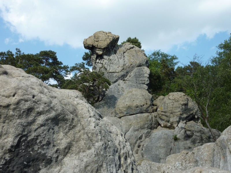
Das „Hockende Weib“ ist ein herausragendes Felsgebilde im westnordwestlichen Abschnitt der Dörenther Klippen, welches einer hockenden Frau ähnelt und als ein Wahrzeichen von Ibbenbüren dient. Mit ihm verbindet sich eine Sage. Deren Inhalt zur Folge erstarrte eine heldenhafte Frau in Vorzeiten zu Stein, was namensgebend war. Diese Frau soll als Mutter mehrerer Kinder in der Nähe der Klippen gelebt haben. Damals sollen die Meeresfluten häufig bis direkt an die Berge gereicht haben. Die Frau, die ihre Kinder vor der außergewöhnlich schnell und hoch steigenden Flut retten wollte, soll sie auf ihren Schultern gehoben und sicher über die Wassermassen gehalten haben, selbst stand bzw. „hockte“ sie dabei im Wasser. Nach langem Warten, Bangen und Beten soll Gott die Flut schließlich wieder zurück geschickt haben, das „Weib“ wurde zu Stein, die Kinder waren jedoch gerettet.
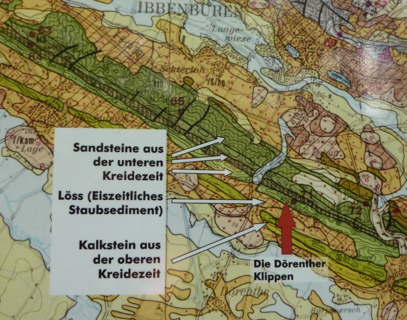
Die Dörenther Klippen sind eine rund 4 km lange und bis 159 m ü. NN hohe Sandstein-Felsformation entlang des oberen Südwesthangs des Teutoburger Waldes. Der überwiegende Teil der Klippen gehört zum Gebiet von Ibbenbüren, der andere befindet sich auf Tecklenburger Gebiet.

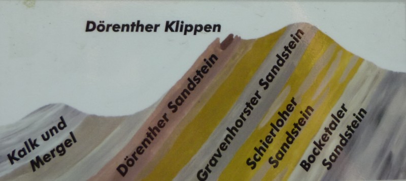
Die Felsen, aus denen die Dörenther Klippen bestehen, lagen früher noch als loser Sand am Strand des urzeitlichen Meeres. Nachdem der Sand zu Stein verfestigt war, wurden die Schichten verbogen und aufgerichtet.

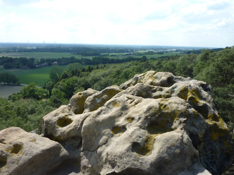
Entlang der Risse und Klüfte, die dabei entstanden, begann die Verwitterung, dem Gestein zuzusetzten. Auch heute noch verwittert das Gestein, wie man an den stellenweise löchrigen Oberflächen erkennen kann. Diese "Wabenverwitterung" folgt den größeren Poren im Gestein, aus denen Salzkristalle (beim Austrocknen) oder Eis (bei Frost) die Sandkörner absprengen.

Vor Ort gibt es eine Informationstafel.
Um den Earthcache loggen zu dürfen müsst ihr folgende Fragen richtig beantworten:
a) Vor wieviel millionen Jahren hätte man dem Rauschen des Meeres lauschen können ?
b) Wie bezeichnet man im Sandstein die steinernen Zeugen des flachen Wassers ?
c) In welchem Bereich der Felsen ist die Wabenbildung besonders gut zu beobachten und warum ?
d) Seit dem 10. Juni 2019 steht es einem EC Owner wieder frei, ein Foto als Beweis des Besuches zu fordern. Ein Foto von sich selbst oder eines persönlichen Gegenstandes vor dem Hintergrund des besuchten Ortes .Falls das Foto nach einer Erinnerung immer noch nicht hochgeladen wird behalte ich mir die Löschung des Logeintrages vor.
Schicke mir deine Antworten per Email an
Ihr könnt sofort loggen,
ich melde mich, wenn etwas an den Antworten nicht stimmt.
Quelle der Bilder:
Terra. Vita
Natur- und Geopark
Nördlicher Teutoburger Wald, Wiehengebirge, Osnabrücker Land e.V.

The "Crouching Woman" (“Das hockende Weib”) is an outstanding formation of rocks in the northwestern portion of the western cliffs of Dörenthe, which looks like a crouching woman. It is a famous landmark of Ibbenbueren and linked to a legend, where a heroic woman was frozen to stone in prehistoric times. This woman (a mother of several children) should have lived near the cliffs. Sometimes the ocean tides were extremely high and passed directly through to the mountains. The woman who wanted to save her children from the exceptionally fast and high-rising tide should have lifted them on her shoulders and kept them safe, she herself stood in the waters steadily or even got "crouched". After long term waiting, worrying and praying to God the tide was finally sent back, but the "woman" remained as a stone. At least the kids were saved.
The cliffs at Dörenthe are about 4 km long and up to 159 m high above sea level. They are made of sandstone as a rock formation along the upper southwest slopes of the Teutoburg Forest. The majority of the cliffs are part of the territory of Ibbenbüren, the smaller part is on the area of Tecklenburg.

In former times the rocks, the Dörenther cliffs consist of, lay as loose sand on the beach of the ancient sea. After the sand was hardened to stone, the layers were bent and straightened.

Along the cracks and crevices the weathering began to destroy the rock. Even today the weathering wears on and on, as can be seen in the sometimes bumpy surfaces. This "honeycomb weathering" follows the larger pores in the rock from which salt crystals (when dry) or ice (frost) pop off the sand grains.

You will find an information board on site.
To log the Earth cache you have to answer the following questions correctly:
a) How many millions of years ago you would have heard the roar of the ocean?
b) How is the name of the stony remains of shallow water?
c) In which area of the rocks, the honeycomb formation observed particularly well and why ?
d) Since June 10, 2019, an EC owner is again free to request a photo as proof of the visit. A photo of yourself or a personal item against the background of the place you visited. If the photo is still not uploaded after a reminder, I reserve the right to delete the log entry.
Send me your answers by email
sharanpower4321@gmail.com
You can log immediately,
I'll let you know if there's anything wrong with the answers.
Source of images:
Terra. Vita
Natur- und Geopark
Nördlicher Teutoburger Wald, Wiehengebirge, Osnabrücker Land e.V.