The Maplewood Conservation Area is a 30 hectare (75 acre) site that is the only remaining mudflats and salt marsh that once ranged along the Burrard Inlet all the way to the First Narrows. The mudflats and foreshore areas provide important habitat areas and are part of the migratory bird Pacific Flyway. The neighbours include a chemical plant to the west and a petroleum refinery directly across the inlet. This unique area is a partnership between the Vancouver Port Authority which leased the lands to Environment Canada for a conservation area, the District of North Vancouver which owns the public area of the park, and Wild Bird Trust, a non profit society selected by Environment Canada to operate the conservation area.
This park has an interesting history. It was home to the Tsleil-Waututh Nation “People of the Inlet” long before Captain George Vancouver sailed past Siwash Rock. It was home to a number of squatters shacks in the early 1970s. The hippie counterculture found that the mudflats (due to hazy land ownership claims in the intertidal zone) were a great place to build and live in relative peace.

The District of North Vancouver wanted to develop the land and tried to remove the community. There became an ongoing protest resulting in a standoff. The District, to “enforce public health standards”, burned down the shacks in 1971 while residents looked on helplessly. An art installation near the posted coordinates pays homage to these squatters who essentially saved Maplewood.

The protest opened a dialogue and pressure was placed on the landowners to preserve this area as a natural conservation area. Parts of the mudflats were dredged and fill was dumped on the foreshore in preparation for a port project that never went ahead. After 20 years the land was finally preserved in 1993.
About the Earthcache:
Please note: The tidal marshes are extremely fragile ecosystems. Even walking on them will cause damage. There is no public access to the tidal marshes though there are several viewpoints. Please read and obey all posted signs.
Also note that dogs are not permitted west of the bridge over the Old Barge Channel.
Mudflats and tidal marshes are part of similar geological actions. Mudflats are located at the lower intertidal area while tidal marshes are located higher in the intertidal zone. There is a dynamic relationship between the two areas. This is governed by the following factors:
1. Sediment supply
2. Tidal action
3. Wind/wave climate
4. Movement of relative sea level
Waves deposit sediment from the mudflats higher onto the shoreline. Once the shoreline is at a certain level, plants can start to take root. These plants trap sediment and contribute organic materials. This forms a nutrient rich area which is provides important biological habitat. High tides wash the sediment out to sea where it remains deposited lower in the intertidal zone or suspended until re-deposited into the same areas.
Wind storms or seasonally high tides (the so called King Tides) will scour more sediment from the marsh areas to start the process over.
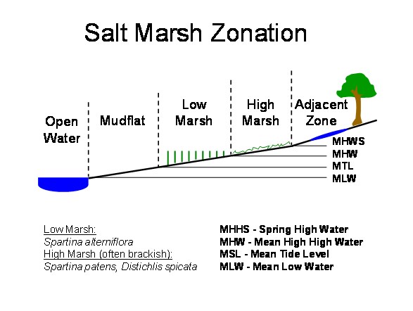
Eventually with enough sedimentation the tidal marshes are pushed further upland and other forms of vegetation take the place of salt tolerant grasses and similar plants. This biological succession provides an observer clues about the relative age of any area.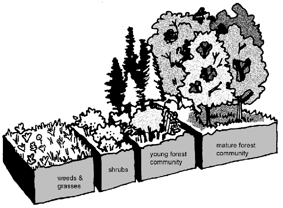
Part of the Maplewood site is located on a degraded industrial site that had been dredged and filled. The Wild Bird Trust worked for a number of years to reclaim this land as an interconnected series of freshwater marshes and waterways.
To log this Earthcache:
The posted location is for the parking area and trailhead. Be mindful about the open hours of the area or you may find your car on the wrong side of an electronically timed gate. The gates close at 6:00 PM weekdays and 4:00 PM Saturday and Sunday. There is no parking on statutory holidays though there is parking located on Dollarton Highway just west of the entrance and you may walk in.
1. Consult the tide table and record the tide at the time of your visit as this will affect your observations. http://www.dairiki.org/tides/monthly.php/van
2. Waypoint 1 – Take the trail east to the Mudflats beach. What type of materials (rocks, earth, etc) do you see when facing the inlet? What approximate size and appearance are the rocks in the area?
3. Waypoint 2 - Once you cross the bridge, take the trail on your left. Proceed along the trail to the next location. Describe what you see to the north side of the trail – this may change depending on the time of year you visit. Would you expect this area to contain primarily fresh or salt water. Why?
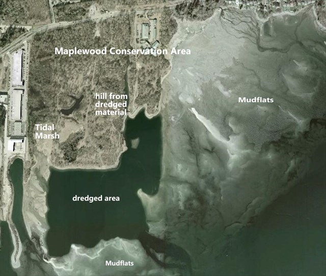
4. How do you think the dredging affected the geological make-up of this area (look at the aerial photo of the area on the cache page). What clues does the vegetation here give you?
5. Proceed to Waypoint 3. You are at a viewpoint to the salt water marsh. Do not go past the fence. Is there an elevation change between the viewpoint and the marsh? Is there a difference in vegetation between the marsh and the trail area, if so what is it? Is the tide on the way in or out?
6. Proceed to Waypoint 4. This is Cates Park appx 4 KM east of Maplewood along Dollarton Highway. Besides the obvious difference in the number of people around please note 3 differences between the two areas:
- What is different about the approach to the beach area from Dollarton Highway?
- What is different about the substrate at the beach?
- What is different about the vegetation in the area (excluding the grass lawns)
Please send me your answers to the questions via my profile at the top of the page. You may log the EarthCache when found but if your answers are not received the log will be deleted as required by the EarthCache program.
Enjoy your walk. Thank you for visiting the EarthCache!
References:
http://www.mainetreefoundation.org/forestfacts/How%20Old%20Is%20Our%20Forest.htm<"> http://www.wildbirdtrust.org/
http://www.warrenpinnacle.com/prof/SLAMM/SLAMM_Model_Overview.html