ATTENTION!
Please send the answers before logging online. If you have internet access for online logging, you have it for sending answers, too.
Photo is mandatory as of 12 June 19, please include all team names when providing the answers.
Sending database answers will NOT give you log permission!
Logging online without sending answers or uploading the picture, or sending database answers will result in log deletion without further notice.
English below

Tonschiefer im Rheinischen Schiefergebirge
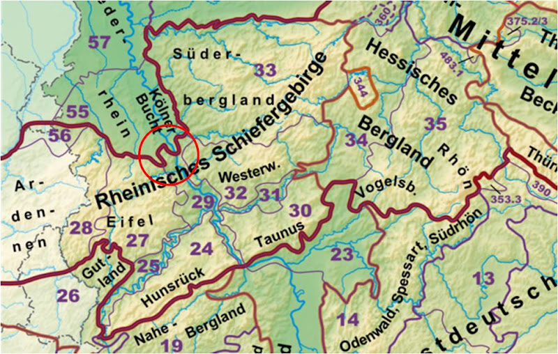
Fast jeder hat bereits in der Schule gelernt, dass vier der deutschen Mittelgebirge geologisch sehr eng zusammenhängen. So bilden Eifel, Hunsrück, Westerwald und Taunus das Rheinische Schiefergebirge. Dieses erstreckt sich auf knapp 26.000 km⊃2; allerdings noch weiter, nämlich von den Ardennen im Westen bis ins Hessische Bergland im Osten, von der Rhön im Südosten bis an die Ruhr im Norden. Hier in Bad Godesberg ist am Aufeinandertreffen von Schiefergebirge und Niederrheinischer Bucht im Godesberger Trichter die linksrheinische, nördliche Grenze zu finden (siehe Abb. 1). Danach flacht das Gelände in die Kölner Bucht hin merklich ab. Das Rheinische Schiefergebirge wird zudem durch den Rheingraben als Verwerfungszone geteilt.

Abb. 1: Karte des Rheinischen Schiefergebirges, roter Kreis zeigt den Raum Bonn
Quelle: https://de.wikipedia.org/wiki/Datei:Haupteinheitengruppen_Rheinisches_Schiefergebirge.png by Elop (CC-BY-SA 3.0)
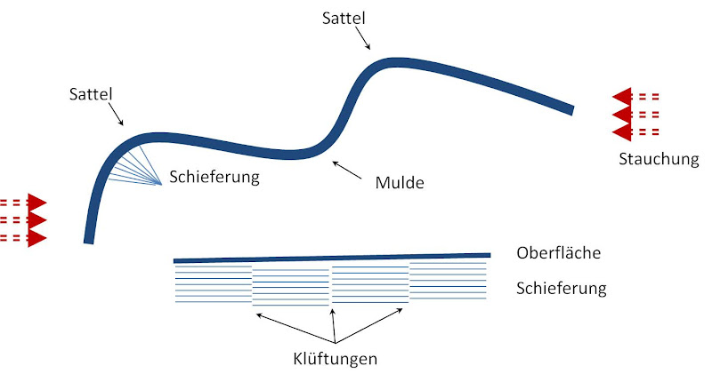
Durch die Auffaltung des Gebirges in der Karbonzeit vor etwa 300 Millionen Jahren, treten hier an der Nordflanke einige im Unterdevon (vor rund 410 Mio Jahren) als äquatornaher Meeresboden abgelagerte Gesteine zu Tage. Besonders hervorzuheben sind hier Sandsteine und Tonschiefer. Es sind einfach geschieferte Gesteine aus Sedimenten, die unter hohem Druck und hohen Temperaturen zu feinen Lagen verdichtet wurden. Dieser Druck entstand während der Auffaltung des Rheinischen Schiefergebirges, bei dem die so typischen geologischen Sättel und Mulden entstanden. Wurde die Spannung in den Faltungen zu hoch, konnten auch so genannte Klüftungen entstehen. Klüftungen sind Versetzungen senkrecht zur Schieferungsfläche. Abbildung 2 zeigt schematisch Sättel und Mulden und mögliche Klüftungen.

Abb. 2: Übersicht über Faltungen und Klüftungen
Zum Earthcache:
Dieser Earthcache führt euch auf drei kurzen Stationen, die dem Geologischen Lehr- und Wanderpfad folgen, zu all den oben angesprochenen geologischen Phänomenen. Die einfache Wegstrecke beträgt etwa 750 Meter und ist zu Fuß oder mit dem Fahrrad zu bewältigen. Es ist ein Waldwirtschaftsweg, der bei schlechter Witterung auch matschig sein kann. Die Wege müssen nicht verlassen werden, alle Informationen sind auch so erreichbar.
Parken könnt ihr beim angegebenen Parkplatz, dort sollten entlang der Straße genügend Plätze zur Verfügung stehen.
Beginnt dann euren Aufstieg bei: REF01
Bei WP01 findet ihr eine Informationstafel des Geopfades, auf der u.a. eine Karte eingezeichnet ist, die das Rheinische Schiefergebirge noch mal in die großgeografische Lage einordnet. Vor euch liegt zu dem eine beeindruckende Wand aus Tonschiefer, die fast senkrecht in die Höhe geht.
An WP02 könnt ihr die Klüftungen im Gestein besonders gut erkennen.
An WP03 befindet sich erneut eine Infotafel, dieses Mal wird auf die Faltung eingegangen.
An REF02 habt ihr einen tollen Ausblick auf Bonn und die dahinter liegende Kölner Bucht.
Um diesen Earthcache zu loggen, beantwortet mir bitte folgende Fragen per Email oder Nachricht:
-
Aus der Kollision welcher großgeografischen Kontinente geht die Bildung des Rheinischen Schiefergebirges zurück?
-
An WP01 findet ihr an und neben der Infotafel auch herabgefallenes Gestein aus der Wand. Schaut es euch an und beschreibt mir bitte die Oberflächenstruktur und Farbe des Gesteins. Ist das Gestein rau oder glatt, unregelmäßig oder definiert, usw... Welches Element ist wohl für die Färbung der Steine verantwortlich?
-
An WP02 fertigt ihr bitte eine kleine Skizze an, auf der die Abbruchwand, die Klüftungen und die Schieferungsebenen zu sehen sind. Diese Skizze hängt ihr bitte eurem Log an. Alternativ beschreibt ihr mir den Verlauf der oberen Kante, der Klüftungen und der Ebenen so detailliert wie möglich in eurer Nachricht.
-
An WP03: Liegt dort eine Mulde oder Sattel vor Euch hinter der Infotafel?
-
Update ab dem 12.06.2019: Mit der Guidelineänderung vom 11.06.2019 dürfen Fotos als Anwesenheitsbeweis wieder gefordert werden (wie bei den neuen Virtuals). Macht also bitte ein Foto von euch an der Location. Auf dem Bild müsst ihr nicht erkennbar sein, ein Körperteil, GPS-Gerät oder anderer persönlicher Gegenstand sind ebenfalls in Ordnung..
Bitte sendet mir die Antworten nur und beantwortet sie nicht in Eurem Log. Nach dem Absenden der Nachricht könnt ihr sofort loggen, ihr müsst nicht auf eine Logfreigabe warten. Falls etwas nicht stimmen sollte, melde ich mich bei Euch. Falls ihr den EC im Team besucht: Bitte tragt alle beteiligten Teammitglieder in der Antwort-Email ein, oder sendet die Email pro Account einzeln.
Quellen:
bonn.de - Geologischer Wanderpfad
Geologischer Dienst NRW (gd.nrw.de)
wikipedia (Rheinisches Schiefergebirge, Schieferung, Tonschiefer)
nach oben

Slate of the Rhenish Massif
In Germany, almost every child learns at school that four of the Central German Uplands (Eifel, Hunsrück, Westerwald and Taunus) define the so called Rhenish Massif. This massif is nearly 26,000 km⊃2; wide and ranges from the Ardennes in the West to the Hessian Hills in the East, from the Rhön in the Southeast to the river Ruhr in the North. Here, in Bad Godesberg you can find the northern boundary on the left side of the river Rhine, where the Rhenish Massif meets the Cologne Lowland (see fig. 1). The Massif is cut in two by the Rhine Fault.

Fig. 1: Map of the Rhenish Massif, red circle marks the Bonn area
Source: https://de.wikipedia.org/wiki/Datei:Haupteinheitengruppen_Rheinisches_Schiefergebirge.png by Elop (CC-BY-SA 3.0)
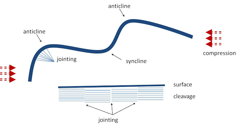
The folding of the massif about 300 million years ago caused the floor of the ocean which had been created by sedimentation during the Early Devonian age to come to the surface. This is visible here at the northern end of the Massif. The rock consists mainly of slate that has been formed into thin layers during the folding under high pressure and temperatures. This folding also caused the typical anticlines and synclines that are visible in the whole area. If the tension inside rock had been too high, jointings occured vertical to the original direction of the cleavage. Figure 2 schematically shows anticlines, synclines and jointings.

Fig. 2: Overview of foldings and jointings
About this Earthcache
This Earthcache leads you to three stations where you can find the phenomena mentioned above. The one-way length is about 750 m, slowly uphill and easily accessible by foot or bike. Please note that the trail is unpaved and may be muddy after rain. You do not have to leave the trails, all information is accessible from the track.
You can park your car at the given parking co-ordinates, there should be plenty of parking space alongside the road.
Begin your ascend at REF01.
At WP01 you will find an information sign showing a map of the Rhenish Massif and its geological surroundings. In front of you is a nearly vertical wall that consists of slate.
At WP02 you can easily spot the jointings in the cleavage.
At WP03 you will find another information sign that explains the different types of foldings.
From REF02 you will have a wonderful view of Bonn and the Cologne Basin behind it. Notice how flat is is!
In order to log this Earthcache as "Found", please send me the answers to the following questions via e-mail or the message system.
- At WP01, two old, colliding continents are mentioned (indicated in bold font at the sign). What are their names?
- Also at WP01: Look at some of the fallen rock that lies near the information sign. Please describe its surface texture and colour. Is it smooth or rough? Which element might be responsible of the colour?
- Please draw a small sketch at WP02, that includes the edge, the cleaving and the jointings as they can be seen on site and attach it to your log. Alternatively, you can describe the outline and the directions of jointings and cleavings as detailed as possible in your message.
- Behind the information sign at WP03: Do you see a syncline or an anticline?
-
Update 12 June 2019: With the change in EarthCache-Guidelines from 11. June 2019, photos as proof of being actually on site are again allowed (same as the new Virtuals). Please take a photo of yourself on site.You don't have to be recognisable, e.g. a part of your body, the GPSr, or a personal item also fulfils this requirement.
Please do not include the answers to the questions in your log, put them in a message to me instead. After messaging me, you don't have to wait for permission, you can log your find right away. I will contact you, if there is something wrong with your answers. If you visit the EC as a team: Please include all team member names in your email, or send the email individually.
Sources:
bonn.de - Geologischer Wanderpfad
Geologischer Dienst NRW (gd.nrw.de)
wikipedia (Rheinisches Schiefergebirge, Schieferung, Tonschiefer)
back to top