Babina I: Źródło wód żelazistych/ Saure Quellen EarthCache
Babina I: Źródło wód żelazistych/ Saure Quellen
-
Difficulty:
-

-
Terrain:
-
Size:  (other)
Please note Use of geocaching.com services is subject to the terms and conditions
in our disclaimer.
Thank you very much to Mosznir for the Polish translation!


Geoturystyczna ścieżka “Stara Kopalnia Babina” biegnie przez część dawnego obszaru górniczego. Eksploatowano tutaj węgiel brunatny oraz iły ceramiczne, zarówno metodą głębinową jak i odkrywkową. Przed wojną obiekt funkcjonował pod nazwą Kopalnia „Babina” (łuż. Babcia), po wojnie przyjął on nazwę „Przyjaźn narodów – szyb Babina”. Całkowita długość ścieżki wynosi 5 kilometrów. Ten Earthcache ma na celu pokazanie Wam najciekawszych geologicznie miejsc po drodze.
Obszar ten charakteryzuje się występowaniem wielu naturalnych źródeł. Niezwykłe znaczenie mają źródła Łuku Mużakowa ( niem. Muskauer Faltenbogen). Tym najbardziej znanym jest Duże Źródło Babina ( niem. Babinaquelle ), bardzo zimne i zawierające sporo związków żelaza. Jako element ścieżki geoturystycznej „Stara Kopalnia Babina” jest dostępne dla odwiedzających przez cały rok.


Źródła to samoczynne i naturalne skoncentrowane wypływy wód podziemnych na powierzchnie terenu, dno zbiornika wodnego lub cieku. W zależności od otaczających wody podziemne warstw skalnych, wypływająca ze źródeł woda może mieć wysoką zawartość minerałów, używana jest wtedy często jako wody lecznicze. Warstwy glebowe dodatkowo filtrują wodę z tych źródeł. Mają one mniej więcej stałą temperaturę od 6 do 10 oC. Zimą są one relatywnie ciepłe i nie zamarzają, a latem tworzą coś na kształt „zimnych wysp”.
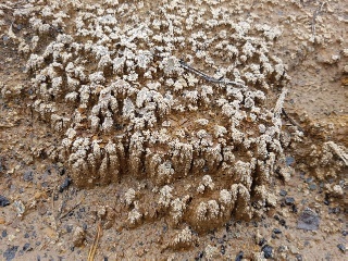
Duże Źródło Babina
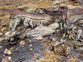
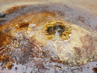
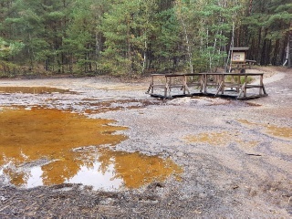
Wody źródła Babiny są bardzo bogate w Żelazo. Ponieważ luźny materiał skalny jest bardzo żelazisty w obszarze podpowierzchniowym, cząstki żelaza są rozpuszczane w wodach gruntowych i transportowane na powierzchnię. Najbardziej widocznym i interesującym miejscem wypływu wód podziemnych jest źródło, znajdujące się w środku misy zbudowanej z osadów żelazistych, które możemy oglądać z kładki spacerowej. Wygląda ono jak mała wybudowana przez człowieka fontanna, ale jest pochodzenia naturalnego. W tym konkretnym przypadku mamy do czynienia z podwójną misą, której krawędź zbudowana jest z mieszaniny żelaza i minerałów składająca się zasadniczo z wodorotlenku żelaza (III), Schwertmannitu, Jarosytu i Goethytu. Te same minerały są szeroko rozpowszechnione w całym otoczeniu źródeł jako rdzawo-brązowe formacje na powierzchni.
Dlaczego woda zawierająca żelazo barwi otoczenie na rdzawy kolor ?
Żelażo na pewnej głębokości jest rozpuszczane jako Fe2 + przez wodę o odczynie kwaśnym ( CO2). U zródła ciśnienie gwałtownie maleje, przez co CO2 ulatnia się, a pH rośnie. Fe2+ wytrąca się w postaci wodorotlenku lub węglanu. Po połączeniu z tlenem z atmosfery Fe2+ utlenia się do Fe3+. To właśnie wtedy tworzy się rdzawy nalot, który możemy zaobserwować w otoczeniu źródła.
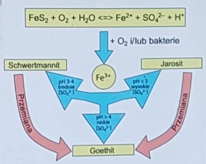
Fazy mineralne Kwaśnych wód kopalnianych
Strefa źródliskowa, a także otaczające je skały osadowe są idealnym miejscem do obserwacji procesow geochemicznych, jakie zachodzą w obszarach dawnej eksploatacji węgla brunatnego. Kwaśne wody kopalniane wykazują pH w zakresie 2-4 oraz wysokie stężenia jonów siarczanowych i metali ciężkich. Kwaśne wody w rejonie Łuku Mużakowa powstały w wyniku procesu intensywnego wietrzenia minerałów siarczkowych (głównie pirytu FeS2 ), które występują w pokładach węgla brunatnego. Wody, znajdujące się w obszarze dawnej kopalni Babina, są złożonymi mieszaninami chemicznymi, które obok wielu innych pierwiastków zawierają głównie żelazo, mangan, wapń magnez, sód, potas, chlor i siarczany. Przeprowadzone badania wód strefy źródliskowej pokazują najwyższe koncentracje żelaza oraz wapnia.
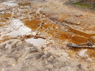
Inne, mniejsze źródła, znajdują się w dnie płynącego obok potoku i wypływają bezpośrednio z jego dna. Znajdujące się tam wody źródlane są pod zmiennym ciśnieniem hydrostatycznym i wypływają pulsacyjnie, co miejscami przypomina niewielkie błotne wulkany.
 Źródła w strumieniu
Czy źródło jest zanieczyszczone?
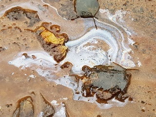
W wypływającej ze źródła wodzie często tworzą się dziwne osady w postaci cienkiej błony na powierzchni. Wyglądają one jak wyciek oleju z silnika, mieniący się w słońcu wszystkimi kolorami tęczy. Nie jest to jednak zanieczyszczenie środowiska, ale bardzo naturalny proces spowodowany przez bakterie żelazowe. Te mikroorganizmy żywią się żelazem zawartym w wodzie i tworzą na niej kożuch bakteryjny.

W bezpośrednim sąsiedztwie źródeł kwaśnych wód kopalnianych, wokół szczątków roślin wytrącają się także osady mineralne. Występują w formie bezbarwnych lub białych wykwitów gipsowych.

Aby zalogować znalezienie tego Earthcacha proszę odwiedź miejsce wskazane przeze mnie miejsce i odpowiedz na następujące pytania:
1. Jaka jest wysokość i średnica podwójnej misy źródlanej widocznej z kładki?
2. Przyjrzyj się dokładnie i opisz budowę tejże misy!
3. Pobierz próbkę wody. Opisz jej barwę. Jeśli chcesz możesz też spróbować smak wody ze źródła!
4. Misy źródlane zbudowane są z różnych minerałów, posiłkując się tekstem z tablicy informacyjnej ustal czym są żółte i brązowe zlepy!
5. Znajdź na powierzchni wody osad wyglądający jak plama oleju. Co stanie się jeśli spróbujesz dotknąć tej plamy ? Czy zachowuje się jak plama oleju?
Zadanie opcjonalne: Zrób zdjęcie swoje lub swojego GPS na ścieżce „Stara Kopalnia Babina” i podziel się nim w logu.
Wyślij do nas maila z odpowiedziami na pytania. Nie musisz czekać aż zaakceptujemy odpowiedzi, możesz logować znalezienie. jeśli coś będzie nie tak skontaktujemy się z Tobą. Życzymy Ci miłej zabawy na tej geologicznej ścieżce!

Der geotouristische Pfad "Alte Grube Babina" läuft über einen Teil des alten Bergbaugebietes, wo Braunkohle und Keramikton gewonnen wurde, und das vor dem Krieg zur Grube "Babina" und der Nachkriegsgrube "Freundschaft der Völker- Babina Schacht" gehörte. Die gesamte Länge des Pfades beträgt 5 km. Mit diesem Earthcache möchten wir euch einen der geologisch interessantesten Orte zeigen.
Das Gebiet des Muskauer Faltenbogens ist reich an natürlichen Quellen. Von enormer Bedeutung sind die Quellen des Łuk Mużakowa. Die bekannteste und schönste, die sogenannte Große Babinaquelle, eine kalte Eisensulfatquelle, besitzt internationale Bedeutung. Als Bestandteil des geotouristischen Pfades „Alte Grube Babina“ (Łęknica, PL) kann sie das ganze Jahr über besichtigt werden.
Als Quellen werden Orte bezeichnet, an denen das Grundwasser auf natürliche Weise an der Erdoberfläche austritt. Je nach Beschaffenheit der darunter liegenden Erdschichten kann Quellwasser einen hohen Mineralgehalt haben und wird oft auch als Heilwasser eingesetzt. Die Erdschichten filtern das Quellwasser. Es hat eine mehr oder weniger konstante Temperatur von 6 bis 10 Grad, das heißt im Winter bleiben sie stets eisfrei und im Sommer wirken sie als "Kälte-Insel".
Die große Babinaquelle
Das Wasser der Großen Babinaquelle ist sehr reich an Eisen. Weil die lockeren Gesteinsmassen im Untergrund sehr stark eisenhaltig sind, werden Eisenpartikel auch im Grundwasser gelöst und mit dem Quellwasser an die Oberfläche getragen. In den Randbereichen lagert sich eisenhaltiger Schlamm ab, welcher mit der Zeit hart wird und die markanten Quelltöpfe formt. Sie sehen aus wie kleine Brunnenringe, sind aber ganz natürlich entstanden. Die große Babinaquelle ist ein Doppelquelltopf, dessen Rand aus einem Eisenmineralgemisch, im Wesentlichen aus Eisen-III-hydroxid, Schwermannit, Jarosit und Goethit besteht. Die gleichen Eisenminerale sind im gesamten Umfeld der Quellen als rostbraune Oberflächenbildungen verbreitet.
Warum färbt das eisenhaltige Wasser die Umgebung braun?
Eisen wird in der Tiefe als Fe2+ durch saures Wasser (CO2) gelöst. An der Quelle verringert sich der Druck rapide,das CO2 entweicht, der pH steigt, Fe2+ fällt als Hydroxid oder Carbonat aus. Oben zu Tage tritt der Sauerstoff hinzu. Fe2+ wird zu Fe3+ oxidiert. Es entsteht "Rost". Dies ist das Resultat der Braunfärbung was Ihr entlang des Quelllaufs hier sehen und beobachten könnt.
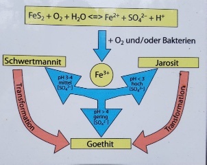
Mineralische Phasen der sauren Bergbaurestgewässer
Dieser Quellenbereich und die ihn umgebenden Gesteinssedimente stellen einen perfekten Ort zur Beobachtung der geochemischen Prozesse dar, welche auf den Gebieten des ehemaligen Abbaus der Braunkohle vorkommen. Das Wasser, mit seinem sehr niedrigen pH-Wert von 2,5 bis 4, fließt hier über unfruchtbare tertiäre Sande, so dass der Quellort nicht, wie allgemein üblich, zugewachsen ist. Die Wässer aus diesem Gebiet enthalten hauptsächlich Eisen, Mangan, Natrium, Kalium, Chlor und Sulfate. Die durchgeführten Untersuchungen beweisen die höchstmögliche Konzentration an Eisen und Calcium.
Andere Quellen sind in der Nähe des kleinen Baches zu sehen. Diese Quellen laufen direkt in den Bach aus. Das dort vorhandene Quellwasser hat einen unterschiedlichen hydrostatischen Druck und läuft pulsierend aus, was manchmal an Schlammvulkane erinnern kann.
 Quellen am und im Bachlauf
Ist die Quelle verschmutzt?
Bei den abfließenden Quellwässern bilden sich häufig schillernde Häutchen. Es sieht dann so aus, als ob Öl ausgelaufen wäre, da die Wasseroberfläche zum Teil in bunten Regenbogenfarben erstrahlt. Dabei handelt es sich allerdings nicht um Umweltverschmutzung, sondern um einen ganz natürlichen Vorgang, der durch eisenliebende Bakterien hervor gerufen wird. Diese Mikroorganismen ernähren sich nämlich von dem gelösten Eisen. Ähnlich aussehende Öl- und Benzinfilme vergrößern sich auf dem Wasser und ändern dabei ihre Farben. Die hier vorliegenden Häutchen reagieren anders.
In der Umgebung des Quellenbereiches der sauren Bergbaurestgewässer fällt auch der mineralische Niederschlag an den Überresten der Pflanzen auf. Die farblosen bis weißen "Salzausblühungen" auf den Eisenmineralien sind kleine Gipskristalle.

Bitte beantwortet bei eurem Besuch an der Quelle folgende Fragen!
1. Welche Höhe und Durchmesser haben die beiden Quelltöpfe am Steg?
2. Schaut euch den Doppelquelltopf aus der Nähe an und beschreibt seinen Aufbau!
3. Nehmt eine Wasserprobe! Welche Farbe hat das Wasser? Wenn ihr euch traut, könnt ihr auch den Geschmack testen!
4. Aus welchen Elementen bestehen die grau-braunen und und die gelben Bestandteile der Quelltöpfe? (Infotafel)
5. Sucht nach den Öl-ähnlichen Flecken im Quellgebiet! Öl würde bei Berührung auseinander laufen. Was passiert, wenn ihr diese Flecken berührt?
Freiwillig: Mache ein Foto von dir/deinem GPS in der Alten Grube Babina und füge es deinem Log bei!
Schickt eine Mail mit euren Antworten an uns! Nach dem Absenden der Antworten könnt ihr gleich loggen. Falls etwas nicht in Ordnung ist, melden wir uns. Ihr braucht nicht unsere Logfreigabe abwarten! Wir wünschen euch viel Spaß bei dieser geologischen Entdeckungsreise!


The "Old Pit Babina" geotourist trail goes over a part of the old mining area, where brown coal and ceramics were won, which belonged to the pit "Babina" before the war and the postwar "Friendship of the peoples Babina Schacht". The total length of the path is 5 km. With this Earthcache we would like to show you one of the most geologically interesting places.
The area of the Muskauer Faltenbogen is rich in natural sources. The sources of Łuk Mużakowa are of enormous importance. The most famous and most beautiful, the so-called Babina Source, a cold source of iron sulphate, has an international significance. As part of the geotouristic path "Old Pit Babina" (Łęknica, PL) it can be visited all year round.


Sources are places where the ground water emerges naturally at the surface of the earth. Depending on the nature of the underlying soil layers, spring water can have a high mineral content and is often used as a healing water. The earth layers filter the spring water. It has a more or less constant temperature of 6 to 10 degrees, ie in winter they always remain free of ice and in summer they act as "cold island".
The Great Babina Source
The water of the Great Babina Source is very rich in iron. Because the loose rock masses are very ferrous in the subsurface, iron particles are also dissolved in the ground water and are carried to the surface with the spring water. In the margins, iron-containing mud deposits are deposited, which over time hardens and forms the prominent spring pots. They look like small fountain rings, but they are natural. The large Babina source is a double source pot whose edge consists of an iron mineral mixture consisting essentially of iron-III hydroxide, schwermannite, jarosite and goethite. The same iron minerals are widely distributed in the entire environment of the sources as rust-brown surface formations.
Why does the iron-containing water brown the environment?
Iron is dissolved in the depth as Fe2 + by acidic water (CO2). At the source the pressure decreases rapidly, the CO2 escapes, the pH increases, Fe2 + precipitates as hydroxide or carbonate. Oxygen is added at the top of the day. Fe2 + is oxidized to Fe3 +. "Rust" is created. This is the result of the brown coloring which you can see and observe along the spring.

Mineral phases of acidic mineral waters
This source area and the sedimentary rocks surrounding it represent a perfect place to observe the geochemical processes occurring in the areas of the former mining of the brown coal. The water, with its very low pH of 2.5 to 4, flows over sterile tertiary sands, so that the source location is not grown as is customary. The waters from this region mainly contain iron, manganese, sodium, potassium, chlorine and sulphates. The investigations carried out prove the highest possible concentration of iron and calcium.
Other sources can be seen near the small creek. These sources run directly into the stream. The spring water there has a different hydrostatic pressure and runs out pulsating, which can sometimes be reminiscent of mud volcanoes.
 Sources in the stream
Is the source polluted?
In the effluent spring waters, frequently pallid cuticles are formed. It then looks as if oil had run out, as the surface of the water is partly shining in colorful rainbow colors. However, this is not a pollution of the environment, but a very natural process caused by ferruginous bacteria. These microorganisms feed on the dissolved iron. Similar oil and gasoline films grow on the water and change their colors. The cuticles present here react differently.

In the vicinity of the source area of the acid mineral water, the mineral precipitation is also found on the remains of the plants. The colorless to white "salt efflorescence" on the iron minerals are gypsum.


Please answer the following questions during your visit to the source!
1. What height and diameter do the two spring pots have on the bridge?
2. Look closely at the double-source pot and describe its construction!
3. Take a water sample! What is the color of the water? If you dare, you can also taste the water.
4. What elements are the gray-brown and yellow constituents of the spring pots? (Information panel)
5. Look for the oil-like spots in the spring area! Oil would run apart when touched. What happens when you touch those stains?
Volunteer: Take a photo of you / your GPS in the old pit Babina and add it to your log!
Send an email with your answers to us! After sending the answers you can log the same. If something is wrong, we will contact you. You do not need to wait for our log release! We wish you lots of fun on this geological discovery tour!
Quellen: wikipedia, Buch: Wanderungen in die Erdgeschichte (24) Muskauer Faltenbogen, Flyer und Broschüren des Geopark Muskauer Faltenbogen, eigene Fotos
Additional Hints
(No hints available.)