INTRODUCTION
You are going to use hyperbolic navigation to find this cache! But don't let that scare you, it's possible to do it with just your GPS receiver, and I'm going to show you how. But first, a little background information.
BACKGROUND INFORMATION
Early electronic navigation systems made use of hyperbolic navigation. The Omega system used 8 stations strategically located around the globe to achieve typically 2.5 nautical mile accuracy. The Loran-C system used a chain of receivers in coastal areas and the Great Lakes to achieve navigation accuracy of about 0.25 nautical mile accuracy. Better accuracy is achieved when the transmitting stations are closer. The Decca portable positioning system was used locally where higher accuracy was necessary.
In general, distance measurements provide better accuracy than angular measurements. All three of the above systems take advantage of this. They essentially determined the difference in time of receipt of synchronized signals from the transmitting stations. A time difference corresponds to a distance difference. Lines of position (LOP's) are formed along which the time (or distance) difference remains constant. These lines happen to have hyperbolic geomety. Navigational charts were printed with these LOP's as overlays.
Study the diagram below to see how the blue hyperbolic LOP's are formed as constant distance differences relative to the green and red transmitting stations. I have drawn a family of 4 of these hyperbolic lines representing distance differences of 6, 7, 8, and 9 units. If there was another station we could form more families of LOP's. It is the intersection of two hyperbolic LOP's from different families that determines a position.
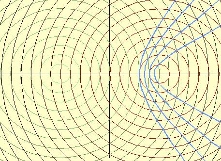
Hyperbolic Lines of Position
FINDING THE CACHE
Go to the posted coordinates of Waypoint A (N45 21.078 W075 44.509). There you will find a black tag with the minute portions of the coordinates of Waypoint B. (The degree portions of all postions are N45 W075.) Now go to Waypoint B where you will find a black tag with the the minute portions of the coordinates of Waypoint C. There is no need to go to Waypoint C. These 3 waypoints are the positions of the (simulated) transmitting stations A,B,C. The cache is on a hyperbolic LOP where its distance from A minus its distance from B equals 3.608 kilometers. The cache is also on another hyperbolic LOP where its distance from B minus its distance from C equals 1.947 kilometers.
Go find the cache which is in the greater Ottawa area. Transportation will be necessary. Once you are in the cache's proximity, you may have to dance a little with your GPS receiver! After the dance, you will have a great appreciation of the marvels of electronic navigational systems which automatically perform the dance steps in real time.
The cache container is a 35mm film can in a familiar holder.
Top marks if you can find the cache without resorting to mapping software, and if you only use one GPSr.
PLEASE do not include spoilers in your logs. Logs with spoilers will be deleted immediately. If you believe there are any problems with the cache setup, please advise me privately by e-mail so that I may fix them if necessary.