 Commander Data
| Trackable Options |
 Found this item? Log in.
 |
 Printable information sheet to attach to Commander Data
Print Info Sheet
Printable information sheet to attach to Commander Data
Print Info Sheet |
|
-
Owner:
-
Qirin
Message this owner
-
Released:
-
Sunday, March 29, 2015
-
Origin:
-
Massachusetts, United States
-
Recently Spotted:
-
In The Great TB Escape

The NCEES Surveyor Trackable
Geocachers and Professional Surveyors (P.S.) share a passion for technology and the outdoors. They both use GPS and surrounding clues to locate hidden marks or objects. But there is a difference. Professional surveyors take that passion for technology and the outdoors to a higher level and turn it into a career.
The NCEES Surveyor Trackable captures that shared passion and brings the surveying profession to life for geocachers. Once you find an NCEES Surveyor Trackable, use its unique code to log it and keep it moving by placing it in another geocache. Before you know it, it will be exploring and mapping the great outdoors just like a Professional Surveyor (P.S.).
The NCEES Surveyor Trackable photo contest has ended, as of June 1, 2015. Please continue the fun and take photos at a National Geodetic Survey (NGS) marker and share it on Facebook or Twitter using the hashtag #PSnoboundaries! Visit geocaching.com/mark to learn about locating NGS survey markers.
NCEES #PSnoboundaries PHOTO CONTEST: The NCEES Surveyor Trackable Photo Contest is solely sponsored by the National Council of Examiners for Engineering and Surveying (NCEES). Open to legal residents of the fifty (50) United States, the District of Columbia, Guam, Northern Mariana Islands, Puerto Rico, and the U.S. Virgin Islands who are 18 years and older at time of entry. Entry period for the contest commences at 12:01 a.m. (EDT) on March 17, 2015, and expires at 11:59 PM (EDT) on June 1, 2015. Void where prohibited. For details and restrictions, see Contest Official Rules on the NCEES website.
This is not collectible.
Use TB726XF to reference this item.
First time logging a Trackable? Click here.
Data collection: Travel from point to point, gathering information, and documenting the journey.
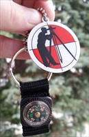
This little surveyor, named after Commander Data from Star Trek Next Generation, wants to roam, surveying: where we go, what the land and climate is like. Commander Data also wants to see the time frame and distance it can travel between pick ups, drops, dips, and discoveries. A little description of the place, journey, people, weather, or something unique is especially encouraged. Pictures are most definitely wanted!
Gallery Images related to Commander Data
View 1 Gallery Image
Tracking History (5768.9mi) View Map