
Educational information:
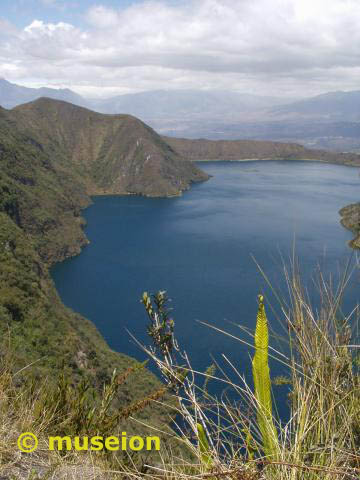
You will find Cuicocha in the western Cordillera of the Ecuadorian Andes in the Imbabura province, about 25 km north of Otavalo. Cuicocha is only 5 km south of Cotacachi, a 4939 m high mountain, ready for slightly experienced mountaineers.
Just a bit further up the lake the Paramo-Region starts.
The lake is situated in the ecological reserve Cotacachi-Cayapas. In this small area you will find evidence for 3 sets of volcanic activities: the already mentioned mountain Cotacachi and another mountain, Yanahurco, and the volcano lake Cuicocha. The name of the latter comes from its appearance: in the old native tongue Quichua Cui means guinea pig and cocha stands for lake.
The name Caldera originates in the spanish word for cauldron. Calderas are volcanic appearances which can be found in almost any central volcano. There are two possibilities for a formation:
A big eruption detonates the volcano top and leaves only the rump. The remaining caldera in the middle fills up with water. Or:
During an eruption the lava is pressed out of the magmatic room. The now empty space can't hold up the above-lying weight of the rocks and part of the vulcano breaks into it; leaving a huge volcanic cauldron. This formation is far more common than the previous mentioned. After a while new lava can flow into the room and bulging the ground another eruption can occur shortly.
Calderas are commonly very deep - sometimes up to 1 km, because of this type of formation. They can have a diameter from only a few km up to 100 km, depending on the size of the volcano.
Because of their history and the associated volcano the lakes have characteristic differences. In the year 1997 a classification model was developed. The division was made by the physicochemical processes in the water:
 Physicochemical classification scheme for volcanic lakes.
Dashed lines indicate tresholds between lake types.
[Pasternack, Varkamp; Volcanic lake systematics 1. Physical constraints; Bull Volcanol (1997) 58:528-538; Springer-Verlag, 1997]; no copyright infringement intended |
In relation to a few other volcano lakes Cuicocha is a fairly small caldera. Nonetheless, it shows the characteristics of one. Very steep - almost vertical - declines form the edges of the lake. The surface area of the lake measures about 3.1 sqkm and 2.6 km in diameter. The depth lies between 135 and 160 m. The oldest crater edge dates from the Pleistocene (Ice Age) and lies to the east of the caldera - it is also the highest - you will need this information when you hike the trail and answer the questions.
The caldera as you see it now has evolved in 3 different stages. First the volcano erupted about 3100 years ago and the resolving crater hole filled up with water later. A few other minor eruptions have formed the islands in the middle.
The older island is also the smaller one, only 350 sqm and a height of 65 m. It is also far more eroded than the younger which has evolved during two different volcano eruptions. Thus also the more prominent double-peaked shape of it. The peaks are not higher than 200 m and the whole island is about 650 sqm in size. The shallow canal between both lakes can be passed by the boat which takes you to the isles during the tour. On both, but esp. the older island you will be able to see rising bubbles at the shores. This is - mostly - volcanic gas (esp. where there is not much plant life).
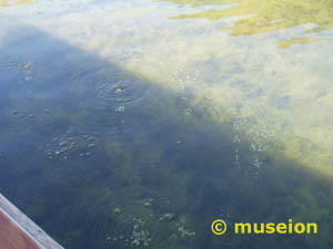 Degassing volcanoes into a lake can be extremely dangerous as the occurences in 1986 at lake Nyos in Africa showed. The toxic emissions from the volcano don't dissolve in the water and form a gas "bubble" at the bottom of the lake. The amount of a gas that will remain dissolved is influenced by the atmospheric pressure to which the lake is exposed at a given altitude, by meteorological conditions, and also by hydrostatic pressure exerted by the stratum of water overlying a particular depth. The amount of gas that can be held in water by the combined atmospheric and hydrostatic pressures at a particular depth is called the absolute saturation. If this gas bubble is disturbed - for example through an earth slide - the physical balance between the water and the gas is turned over. The convections and turbulences result in the gases being spontaneously released into the air above the water where they can extend quickly. Depending on the amount of toxic gas it can lead to major catastrophies regarding animal life (see further down.)
 Now on to your tasks here. Apart from the pictures which must be included in your log, please do not include the answers. Mail them to me instead. I strongly recommend that you try to be discreet about taking pictures when walking along the trail by yourself. I am not so certain of current events, but even years ago it was not really safe to run around with hi-tech equipment. I met a few people who were robbed walking the trail around the caldera and this hasn't stopped so far. Please do not go alone and don't have your technical gear in plain sight! Don't worry, I don't want to scare you, but I also want to mention this so you will be warned. You are fine as long as you don't go alone. Even if you are you might be ok. Just a friendly warning. Most people have their gear with them and have no problems (so did I, but I was "safeguarded" by my Ecuadorian team.) If you don't want to take camera or GPS with you (there is a Traditional there lately - it might be worth it) I give you another opportunity to fullfill the conditions of the log:
When you are walking the trail:
1.1 Does the top of the tallest island reach the highest point at the caldera edge or is it lower? The highest point of the island you need is 3246 m. If you don't take your GPS with you - try to guess during your hike.
1.2 Include in the log a picture of yourself at the lake with the islands also showing (your GPS should be visible). If you don't take camera or GPS then this is redundant of course. Instead I want a picture in Otavalo with you (or part of you) and your GPS at the upper market in front of the big statue. Please send me the coordinates of that as well.
1.3 There is a (visible) river bed - usually dried out - along one of the sides of the caldera ridge (not on the inner lake side). Along which side is it? (for example: on the same side as Imbabura, across it, 90 ° in which direction of the caldera, etc.?) Proving basically that you really have been there.
When you take the boat tour
2.1 Include in the log a picture of yourself at the lake with the islands also showing (your GPS should be visible).
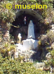
2.2 On the slopes to one of the islands is a statue of a Madonna. Which island is it and in which direction does it show? An approximation is enough as you are not allowed to step on the isles.
2.3 I want to know on which island the boat stops for you to admire the beach. If you do take some pictures of bubbles - that would be grand. But the pic is only additional.
If you do neither:
3.1 Include in the log a picture of yourself at the lake with the islands also showing (your GPS should be visible).
3.2 Tell me which island is the taller one and which one houses a statue of a Madonna. You might need to ask some locals for the information.
3.3 What are the bearings of the Cotacachi from the little harbour where the boat tour starts? If it is in clouds, make an approximation.
I also remembered, that in order to get to the lake you have to pay a fee further down the road (I never had to because of our research.) As far as I was told by a tourist it was $1.00 per person for non-Ecuadorians on a tourist visa. It is 0.50 cents for Ecuadorians and residents.
Additional scientific information on the potential dangers of volcano lakes:
The lake Nyos disaster in Cameroon, Africa, which claimed 1800 human victims in August 1986 as well as 3500 livestock in an area of 20 km surrounding the lake. What happened? "A cloud of dense gas erupted from the lake, covering the surrounding area under a deadly blanket several tens of meters thick, for an unknown amount of time. The source of the gas became clear in the aftermath of the disasters, since the normally clear waters of the lakes turned reddish and the lake shores were severely disturbed by waves and strong winds. No one in the path of the cloud managed to escape its lethal effects. Skin discoloration found on some victims were tentatively interpreted as burns, but this diagnosis is still controversial. Witnesses on topographic hights report a loud noise originating from the lake and, in the case of lake Nyos, flashes of light visible over the lake ; both disasters occurred at night, darkness adding to the mystery of these dreadful natural catastrophes. Ten years later, the causes and mechanism of these tragedies are much better understood, albeit not yet completely elucidated." [.../nyos/project/...] In order to prevent similar occurences a global search for similar lakes - both in history and proximity to inhabited areas - has been invoked. These lakes being systematically analyzed and checked for the potential danger.
