The area you will need to get to for this EarthCache is easily accessible, strollers ok, but wheelchairs probably not.
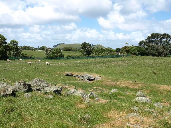 Ambury Farm with Mangere Mountain in the background
Mangere Mountain erupted 18,000 years ago leaving the landscape bare. At the GZ the ground you are standing on once flowed as molten rivers of lava at speeds of up to 30 kilometres an hour and temperatures up to 1100 deg Celsius !! Further up the volcano frothy gas filled lava spewed out like a shaken up soft drink bottle. The gas soon evaporated leaving small air pockets in the rock when it hardened. This type of rock, called scoria, forms the cone of the volcano. The small cave at the GZ is one of the 12 lava caves located in the park. From the cave look west and you will clearly see the top of the tube flowing to the sea.
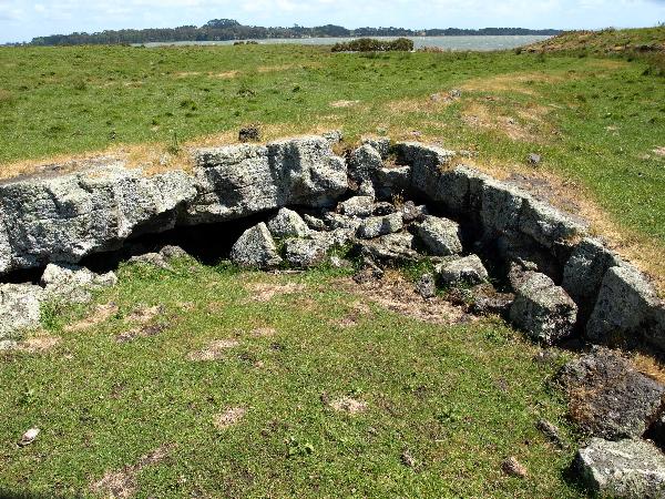 Lava Tube with Manukau Harbour in the distance
Geology
Ambury Regional Park covers much of the western lava field produced by basalt lava flows from Mangere Mountain, a prominent scoria cone, one of the largest and best preserved of Auckland’s 48 volcanoes. The lava was generally frothy and spread out in thin-branching flows, which cooled quickly. There are several types of lava surface textures exposed on the foreshore of Ambury Regional Park and Mangere Inlet, including pahoehoe (smooth, congealed surfaces with wrinkles) and flat slabs with shrinkage cracks forming polygons to give a honeycomb effect. These landforms have been given national importance by the Geopreservation Inventory (Kenny and Hayward 1993). Where the lava engulfed vegetation, it cooled around trees and fallen branches, burning the wood away to leave tree moulds. In some places where the molten lava continued to flow beneath hardened surfaces, hollow spaces such as caves and blisters formed. These blisters, some with their roofs caved in giving a crater-like appearance, are best seen on the foreshore. Twelve lava caves have been located in the park.
When Mangere Mountain erupted about 18,000 years ago during the last Ice Age (20,000 – 10,000 years ago), the sea level was lower than at present and a small river flowed down a valley from Otahuhu into the ancestral Manukau River which flowed towards the present harbour entrance. During the later stages of the mountain’s eruption, volcanic ash was showered over a wide area and many of the lava deposits were inundated by the subsequent rising sea level which formed the Manukau Harbour.
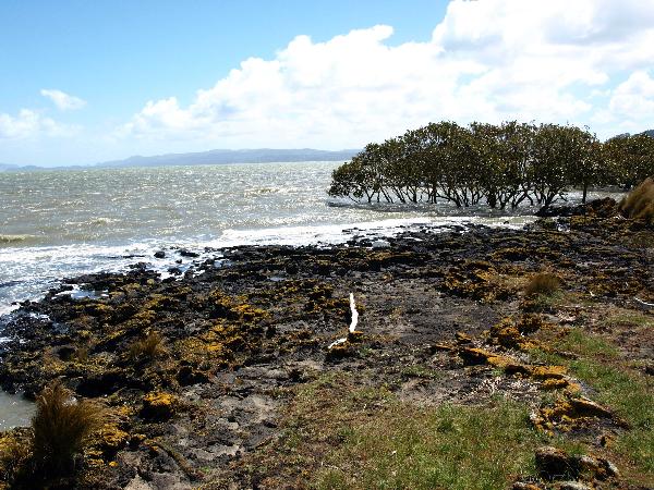 Lava Outflow into Manukau Harbour
History
Nearby Mangere Mountain was once the site of large fortified Maori pa and the area now known as Ambury Regional Park was used by Maori for gardening. The area also provided easy access to seafood (kaimoana) and canoe launching sites for the various iwi (including Wia-o-Hua and Ngati Whatua) who lived in and around the pa. The park and the Otuataua Stonefields to the south of it are the only places in Auckland where Maori stone structures remain on public land. Stone mounds at Ambury mark pre-European gardening sites.
The dry stone walls bordering the drive into the park date from the mid 1800s when farmers from Cornwall and Scotland built them. Volunteers have worked to restore the walls. You can also see the remains of a windmill and wells that were part of the Ambury Milk company.
Archaeology
Ambury Regional Park and the Otuataua Stonefields to the south (Manukau City Council historic reserve) are regionally important, as they are the only places in the Auckland region where Maori stone structures occur on publicly owned land. Ambury Regional Park and the Mangere area generally contain undefended settlements, defended sites and gardens in a connected group of related sites of significant historic value. Approximately 100 archaeological sites have been recorded on Ambury Regional Park, the majority of which are midden and stone structures, including stone rows and mounds. Caves have been recorded as sites as midden material is often associated with them. A fine example can be seen on the area known as the School Paddock. Only 10 pits and terraces have been recorded on the park reflecting the rocky nature of the land.
The most intact group of archaeological features consisting of stone mounds and garden walls is located at the north-eastern end of the Park. Sites in good condition including obvious stone rows, are also located around the western coastline of the park.
The archaeological sites of the north-east and west of Ambury Regional Park are believed to be two separate major concentrations of settlement. The former was relatively stone-free fertile volcanic soil, used predominantly for gardening. The coastal sites were probably associated with fishing activities. Both areas comprised sites relating to domestic living, such as house terraces, platforms and middens (MacDonald and Bulmer 1981). It is likely that the area was repeatedly, if not continuously, occupied because of the good garden land. Archaeological features on the northern coast and in the south-eastern area indicate that there were extensive villages.
Once you complete the following EarthCache requirements you can post your find without delay, as per the EarthCache guidelines. You will also need to verify your find by sending us a message with your answers to these questions and we will answer in due course:
1. Use the text "Ambury Farm Lava Tubes - GC1JPE6" in your email.
2. Located at or near the GZ you will find the answers to the following questions:
a. What two special residents are found in the caves?
b. What is the Hawaiian word for the black wrinkled rock found at the outflow?
3. (Optional). Stand in the depression of the cave and take a photo holding your GPS and post it with your log.
4. From the cave look west and you will clearly see the top of the tube flowing to the sea. Follow the tube and you will see where the lava flowed into the sea. What is the distance “as the crow flies” from the middle of the lava cave to the lava out flow on the foreshore?
Placed by a member of The Kiwicaching Association of NZ