Under Cover Ohio Challenge Mystery Cache
Under Cover Ohio Challenge
Please note Use of geocaching.com services is subject to the terms and conditions
in our disclaimer.
*** The cache is at the posted
coordinates! ***
** You MUST first complete the Challenge **
** to claim a Smiley for this cache! **
You can find the cache.
You can look at the cache.
You can touch the cache.
BUT, you may NOT sign the log until you have
COMPLETED THE REQUIREMENTS.
Under Cover Ohio
Challenge
The United States once had thousands of covered
wooden bridges, giving the nation's landscape a signature look that
still resonates today. Reportedly, Ohio alone once had 4,000
covered bridges dotting it's landscape. Today, fewer than 1,000
covered bridges, historic or modern, remain nationwide, including
141 in Ohio, second only to Pennsylvania's 222. Although many
communities have taken steps to preserve and restore many of them,
the number dwindles every year because of arson, obsolescence and
disrepair.
Many have been posted to the National Register of Historic Places
as an effort to help protect and preserve them for future
generations.
Although covered bridges had their intended use, Yankee ingenuity
came to the fore regarding their "other" uses.
At times, they were used as a drill floor for militia camp
meetings, in case of rain.
The latticework of the bridges made an excellent hiding place for
weapons.
How many bottles of bootleg whiskey lay undetected by customs
agents in Prohibition days?
These bridges served other purposes as well.
The trout fisherman looked to the pool under the bridge for a good
catch.
Children enjoyed the pool as a swimming hole that was sheltered
where they could splash without worry of a bathing suit.
In horse and buggy days, young lovers took advantage of the privacy
to steal a kiss, thus causing the old covered bridges to be known
as "Kissing Bridges". A slow horse, a long bridge, and a willing
girl could produce two kisses.
Old fashioned square dances were sometimes held in the covered
bridge.

Charleton Mill Covered Bridge - Greene County
In order to complete the Under Cover
Ohio Challenge, you must find and log 25 caches highlighting
Historic Ohio Covered Bridges or modern reproductions of
Historic Ohio Covered Bridges.
The QUALIFYING caches are listed on a
bookmark list.
Just click on the link below.
Under Cover Ohio Challenge
for Ohio's Historic Covered Bridges
To view view ARCHIVED Covered Bridge
Caches
Just click on the link below.
Archived Ohio Historic Covered Bridge
Caches
The bookmarks are named by county first, then the cache name (ex.
Greene County - Under Cover).
*** Active Qualifying
Caches ***
as of: November 26, 2009
there are: 87 active
caches
If you own a cache at any Modern or Historic
Ohio Covered Bridge, then that counts as 1 find for you for
each cache you own.
ONLY OHIO COVERED BRIDGES
COUNT
RULES
TO COMPLETE THE UNDER
COVER OHIO CHALLENGE:
1.) Create a public bookmark titled for the Challenge.
2.) Successfully find and log any Ohio Covered Bridge cache
on the list.
- Include this cache in your bookmark.
- Keep this bookmark public until you have completed the
challenge.
- In the cache's bookmark comments, include the date you found the
cache.
IF YOU ARE NOT A PREMIUM MEMBER: Just keep track, and post a note
of all 25 when you've completed the Challenge.
3.) If you have previously found some caches at any of the Modern
or Historic Ohio Covered Bridges, be sure to include them AS
LONG AS THE CACHE IS STILL ACTIVE.
- Previous finds count as long as the cache is STILL active.
- Previous finds on caches archived BEFORE January 13, 2009 (the
publish date of Under Cover Ohio Challenge)
DO NOT COUNT.
- Finds on caches archived AFTER January 13, 2009 will be
allowed.
4.) Do you find that there aren't many Ohio Covered Bridges
highlighted by caches in your area?
Then start driving. There are a few counties out there with 5 or
more Covered Bridges highlighted with a cache.
CACHES ARCHIVED AFTER JANUARY 13,
2009
All previous finds on these caches still
count.
GC14ADJ - BiT's SMSI #3-Born in 1879 (Archived
01-24-09)
GCRXV0 - Down Under (Archived 04-04-09)
GC1945F - Under Cover Cache (Archived
01-25-09)
GC14J9F - COX BRIDGE (Archived 05-19-09)
GCQ2QG - #6 Bridges of Fairfield County - Johnston
Bridge (Archived 05-25-09)
GC1HPXR - Gearhart #1 (Archived 06-01-09)
GCJ1DC - Blackwood Bridge Cache (Archived
07-13-09)
GC10V3A - Glen Helen Covered Bridge (Archived
09-10-09)
GC1N2A1 - Rock Legend (Archived 09-11-09)
GC1D08Y - Covered Bridge (Archived
11-22-09)
EXCLUDED BRIDGES AND
CACHES:
1.) Ohio Covered Bridge caches archived BEFORE
January 13, 2009 are excluded from the Challenge.
- They are ONLY bookmarked to highlight the Covered Bridge and it's
location for those who are interested.
- The bookmark will be removed from the archived cache if and when
an active cache is placed at the Covered Bridge, if possible, and
all information transferred to the bookmark for the active
cache.
2.) Newer Covered Bridges NOT listed on the ODOT and Historic
Bridges of the U.S. websites.
3.) Newer Covered Bridges NOT of any of the "classic"
designs.
4.) Covered Bridges that were NOT and NEVER will be open to vehicle
traffic.
5.) Newer ornamental pedestrian pedestrian Covered Bridges
6.) Because I didn't want to include it in the Challenge for any of
the above reasons and I said so.
BRIDGES WITH MULTIPLE
CACHES:
1.) If a Covered Bridge has MORE than 1 cache at it's location, in
the case of the Smolen-Gulf Covered Bridge in Ashtabula County,
which has 2 caches, then:
only 1 qualifying cache may be claimed per
bridge
THE BONUS OF THIS CHALLENGE:
You get to see and enjoy at least 25 Ohio Covered Bridges in
person.

Germantown Covered Bridge - Montgomery County
There are quite a few Modern and Historic
Ohio Covered Bridges that are not highlighted by a geocache,
so if you have a Covered Bridge near you that does not have a
cache, then you may wish to try to place a cache at it's location,
let me know about the cache when it is published and I will add it
to the bookmark list.
Some, unfortunately, are on private property, so hiding a cache at
them will be near impossible.
MAKE SURE YOU GET PERMISSION IF YOU NEED TO!!
Below is a list of Ohio Covered Bridges and their
locations.
Those crossed out are either already highlighted by a geocache, on
private property or simply not allowed:
Adams County
Governor Kirker Covered Bridge, 1890 - N 38° 47.019 W 083°
36.211
Harshaville Covered Bridge, 1860 - N 38° 54.469 W 083°
32.627
Ashtabula County
Benetka Road Covered Bridge, 1900 - N 41° 50.906 W 080°
41.353
Caine Road Covered Bridge, 1986 - N41° 45.890 W080° 36.979
(newer reproduction)
Creek Road Covered Bridge, 1880 - N 41° 55.183 W 080°
36.576
Doyle Road (Mullen) Covered Bridge, 1876 - N41 45.727 W080
47.401
Giddings Road Covered Bridge, 1995 - N41 45.885 W080 43.960
(newer reproduction)
Graham Road Covered Bridge, 1867 - N41 46.902 W080
37.061
Harperfield (Harpersville) Covered Bridge, 1868 - N 41° 45.367 W
080° 56.651
Mechanicsville Covered Bridge, 1867 - N 41° 45.294 W 080°
53.862
Middle Road Covered Bridge, 1868 - N41 54.116 W080
32.817
Netcher Road Covered Bridge, 1999 - N41 44.225 W80 43.890 (newer
reproduction)
Olin (Dewey Road) Covered Bridge, 1873 - N 41° 51.767 W 080°
43.268
Riverdale Road Covered Bridge, 1900 - N41 40.402 W080
52.320
Root Road Covered Bridge, 1868 - N 41° 50.002 W 080°
37.144
Smolen-Gulf Covered Bridge, 2008 - N 41° 51.352 W 080° 45.567
(newer reproduction)
South Denmark Rd Covered Bridge, 1868 - N41° 43.152 W080°
41.757
State Road Covered Bridge, 1900 - N 41° 53.175 W 080°
37.234
Warner Hollow (Windsor Mills) Covered Bridge, 1867 - N41° 31.982
W080° 57.835
Athens County
Blackwood Covered Bridge, 1879 - N 39° 11.828 W 081°
58.453
Kidwell Covered Bridge, 1880 - N 39° 27.349 W 082°
06.202
Palos (Newton) Covered Bridge, 1876 - N 39° 31.502 W 082°
04.289
Auglaize County
Memorial Covered Bridge, 1992 - N 40° 32.542 W 084° 23.208 (newer
reproduction)
Belmont County
Shaeffer/Campbell Covered Bridge, 1891 - N 40° 04.463 W 080°
58.261
Brown County
Brown Covered Bridge, 1880 - N 38° 59.429 W 083°
53.367
George Miller Covered Bridge, 1878 - N 38° 50.288 W 083°
45.104
McCafferty Covered Bridge, 1877 - N 39° 09.087 W 083°
59.651
New Hope Covered Bridge, 1878 - N 38° 57.587 W 083°
54.921
North Pole Covered Bridge, 1875 - N 38° 44.989 W 083°
46.394
Butler County
Black (Pugh's Mill) Covered Bridge, 1868-69 - N 39° 31.435 W
084° 44.093
Governor Bebb Park Covered Bridge, 1867-68 - N 39° 22.891 W 084°
48.826
Carroll County
Blue Bird Farm Covered Bridge, 1996 - N 40° 33.985 W 081° 05.021
(modern reproduction on PRIVATE PROPERTY)
Clermont County
Stonelick Covered Bridge, 1878 - N 39° 07.900 W 084°
11.235
Clinton County
Martinsville Covered Bridge, 1871 - N 39° 19.797 W 083°
50.095
Cochocton County
Helmick Covered Bridge, 1863 - N 40° 23.582 W 081°
56.574
Columbiana County
Church Hill Road Covered Bridge, 1870 - N 40° 45.718 W 080°
42.218
McClellan Covered Bridge, 1875 - N 40° 43.734 W 080°
50.136
Sells Covered Bridge, 1878 - N 40° 45.052 W 080°
51.418
Teagarden Covered Bridge, 1876 - N 40° 49.301 W 080°
49.621
Thomas Malon Covered Bridge, 1870 - N 40 44.112 W 080 36.575
Cuyahoga County
Charles Harding Memorial Covered Bridge, 1998 - approximate
location: N41° 22.667 W81° 54.047
Delaware County
Chambers Road Covered Bridge, 1883 - N 40° 20.296 W 082°
49.073
Fairfield County
Charles Holiday Covered Bridge, 1897 - N 39° 53.777 W 082°
31.555
Hannaway Covered Bridge, 1904 - N 39° 37.112 W 082°
40.822
Hartman #2 (Lockville Park) Covered Bridge, 1888 - N 39° 49.268
W 082° 44.239
Hizey Covered Bridge, 1891 - N 39° 54.879 W 082° 42.564 (on
PRIVATE PROPERTY)
Hutchinsl Covered Bridge, 1904 - (Alley Park) approximate location
39° 41.287 W082° 34.858
John Bright No. 2 Covered Bridge, 1881 - approximate location: N39°
44.285 W082° 35.070
Johnson/Johnston (Terry Mill) Covered Bridge, 1887 - N 39° 36.813 W
082° 39.525
Jon Raab Covered Bridge, 1891 - N 39° 43.846 W 082° 29.229 (on
PRIVATE PROPERTY)
McCleery Covered Bridge, 1864 - N 39° 48.772 W 082° 733 (approx.
location on PRIVATE PROPERTY)
Mink Hollow Covered Bridge, 1887 - N 39° 38.327 W 082°
38.997
R.F. Baker Covered Bridge, 1871 - N39° 45.030 W082° 28.009
(BEHIND SCHOOL PROPERTY)
Rock Mill Covered Bridge, 1901 - N39° 44.933 W082° 42.804
Roley School House (Basil Canal) Covered Bridge, 1899 - N 39°
43.483 W 082° 36.089
Shade Covered Bridge, 1891 - N 39° 36.451 W 082° 31.758 (on
PRIVATE PROPERTY)
Shreyer Covered Bridge, 1891 - N 39° 50.794 W 082° 41.118
(approx. location on PRIVATE PROPERTY)
Zeller-Smith Covered Bridge, 1906 - N 39° 52.834 W 082°
44.826
Greene County
Ballard Road Covered Bridge, 1883 - N 39° 40.697 W 083°
48.900
Cemetery Road (Glen Helen) Covered Bridge,1886 - N39° 47.117
W083° 52.681 (NO CACHES ALLOWED)
Charlton Mill Covered Bridge, 1882 - N 39° 43.758 W 083°
52.241
Engle Mill Covered Bridge, 1877 - N 39° 34.922 W 083°
55.318
Stevenson Road Covered Bridge, 1877 - N 39° 44.093 W 083°
53.939
Guernsey County
Armstrong (Clio) Covered Bridge, 1849 - N40° 02.224 W081°
35.257
Highland County
Lynchburg Covered Bridge, 1870 - N39° 14.703 W083°
47.661
Jackson County
Buckeye Furnace Covered Bridge, 1872 - N39° 02.251 W082°
27.571
Byer Covered Bridge, 1872 - N39 10.887 W082 38.005
Johnson Road (Crabtree or Petersburg) Covered Bridge, 1870 - N 38°
57.525 W 082° 47.262
Jefferson County
Hindman Memorial Covered Bridge, 1997 - N40 27.896 W080 44.790
(newer reproduction)
Lawrence County
Scottown Covered Bridge, 1877 - N 38° 32.876 W 082° 22.818
Licking County
Girl Scout Camp Covered Bridge, 1882 - N 40° 14.008 W 082°
14.984
McLain Covered Bridge, 1871 - N 40° 05.084 W 082° 36.274
Logan County
Bickham Covered Bridge, 1877 - N 40° 28.449 W 083° 50.411
Miami County
Eldean Road Covered Bridge - 1860 - N 40° 04.673 W 084°
13.022
Fletcher Covered Bridge - N 40° 08.779 W 084° 06.755
Montgomery County (originally in Greene County)
Feedwire Road Covered Bridge, 1870 - (located in Carillon Park
in Dayton)
Germantown Covered Bridge, 1870 - N 39° 37.576 W 084°
21.878
Jasper Road (Huston Brown or Mudlick) Covered Bridge, 1877 - N
39° 37.011 W 084° 23.346 (on PRIVATE PROPERTY)
Morgan County
Adams (San Toy) Covered Bridge, 1875 - N39 37.992 W82
00.925
Barkhurst Mill (Williams) Covered Bridge, 1872 - approximate
location: N39 29.720 W081 50.491
Milton Dye Covered Bridge, 1925 - N39 44.244 W081 42.288
Rosseeau (Fairgrounds) Covered Bridge, ?date? - approximate
location: N39 37.897 W081 49.584
Perry County
Bowman Mill (Reddington) Covered Bridge, 1859 or 1889 - N39 47.884
W082 21.654
Pickaway County
Blackburn (Wesner) Covered Bridge, 1885 - general location N39
45.633 W082 51.121
(somewhere in Slate Run Park)
Preble County
Brubaker Covered Bridge, 1887 - N 39° 39.088 W 084°
32.629
Christman Covered Bridge, 1895 - N 39° 46.213 W 084°
39.316
Dixon's Branch Covered Bridge, 1887 - N39° 50.749 W084°
32.134
Geeting Covered Bridge, 1894 - N 39° 50.622 W 084°
35.816
Harshman Covered Bridge, 1894 - N 39° 42.144 W 084°
46.177
Roberts Covered Bridge, 1829 - N 39° 44.439 W 084°
38.316
Warnke (Swamp Creek) Covered Bridge, 1895 - N 39° 52.424 W 084°
30.880
Ross County
South Salem (Buckskin) Covered Bridge, 1900 - N39° 20.033 W083°
18.874
Sandusky County
Mull Road Covered Bridge, 1851 - N41° 15.657 W083° 11.082
Summit County
Everett Road Covered Bridge, 1870 - N41° 12.233 W081° 35.007
Trumbull County
Newton Falls Covered Bridge, 1831 - N41° 11.175 W080° 58.175
Union County
Upper Darby (Pottersburg) Covered Bridge, 1868 - N40° 14.946 W083°
31.990
Vinton County
Bay (Tinker) Covered Bridge, 1876 - approximate location N39°
16.074 W082° 28.544
Cox Covered Bridge, 1884 - N39° 21.957 W082° 27.631
Mount Olive Road Covered Bridge, 1875 - N39° 17.170 W082°
35.322
Warren County
Corwin M. Nixon Covered Bridge, 1982 - N 39° 29.842 W 084°
06.110 (modern reproduction)
Warren County
Bell Covered Bridge, 1888 - N 39° 25.865 W 081° 40.570
Harra Covered Bridge, 1878 - N 39° 29.267 W 081°
38.869
Henry Covered Bridge, 1894 - N 39° 23.000 W 081°
47.104
Hills (Hildreth) Covered Bridge, 1878 - N 39° 25.636 W 081°
21.668
Hune (Gallagher Ford) Covered Bridge, 1879 - N 39° 30.637 W 081°
15.025
Mill Branch Covered Bridge, ?date? - N 39° N 39° 23.958 W 081°
40.058
Rinard (Hendershott's Ford) Covered Bridge, 1876 - N 39° 32.218
W 081° 13.372
Root Covered Bridge, 1878 - N 39° 20.543 W 081° 45.265
Shinn Covered Bridge, 1886 - N 39° 27.768 W 081°
45.656
Williams County
Lockport Covered Bridge, 1999 - N 41° 32.777 W 084° 23.415
(modern reproduction)
Wyandot County
Swartz Covered Bridge, 1878 - N 40° 46.236 W 083°
10.134
Parker Covered Bridge, 1873 - N 40° 54.176 W 083°
14.683
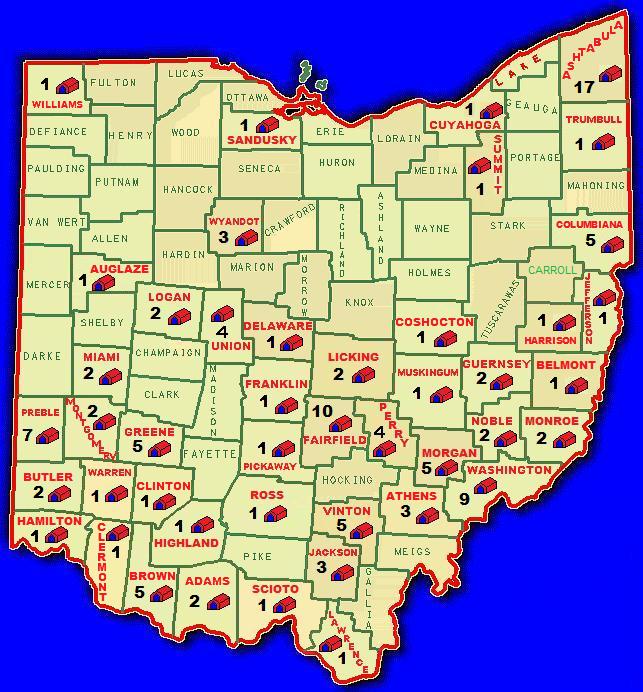
This REVISED version of the ODOT County Covered Bridge map only
shows the number of Covered Bridges that are or are able to be
geocache sites.
These numbers are minus those Covered Bridges on private property
or off limits.
Additional Hints
(Decrypt)
gur pnpur vf uvqqra haqre n snyyra gerr arne gur ebbg onfr
Treasures
You'll collect a digital Treasure from one of these collections when you find and log this geocache:

Loading Treasures