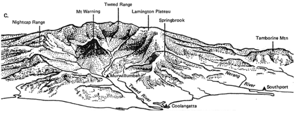
The Tweed Caldera is the largest erosion caldera in the southern hemisphere at over 1000m deep and 40km in diameter. The size of the caldera gives some inkling of the massive size of the Tweed/Mt Warning shield volcano, which is estimated to have been over 2000m tall and around 100km in diameter.
This caldera is also one of the few places where erosion process can be seen taking place in the underlying pre-volcanic sedimentary and metamorphic rocks, providing enthusiasts with a wonderful opportunity to test their knowledge of geological processes.
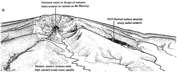
Springbrook, and other plateaus in the area, exist today because of the tough erosion-resistant rhyolite layer of volcanic rock, exhibited in the prominent cliffs of the region, sitting on top of softer basalt and other layers below. In many locations around the caldera, caves have formed under the rhyolite layer into the softer layers underneath.
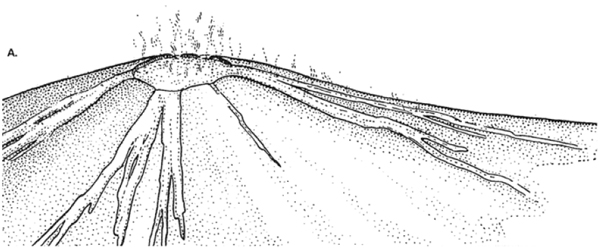
The Tweed volcano was active about 23-25 million years ago as the area passed over a magma hotspot in the earth's crust as Australia slowly drifts to the north. Its eruption spread material unconformably over the older sedimentary and metamorphic rocks exposed in the basin.
Molten material flowed from the Tweed volcano, spreading to the north forming Mt Tamborine, and to the coast forming headlands such as Burleigh Heads. Mt Warning, to the south and at just over 1100 metres tall, is the remains of the hard volcanic plug in the centre of the volcano and can be seen from this lookout.
Diagrams A, B and C, below, demonstrate the process by which the caldera formed, from the massive shield volcano (in A), to present day (shown in C).
This Earthcache
To log this earthcache you will need to visit the published coordinates and perform the following tasks:
1. Read the information sign at the lookout and email the cache owner with the answer to the following question: In as precise wording as possible, from the information panel, how has the volcano come to be in its present shape?
2. Take a photo of yourself and your GPSr clearly visible, with Mt Warning in the background. Upload this photo with your online log.
You can log this cache straight away after you have emailed your answers to the cache owner, no need to wait for confirmation. Please include the name of this earthcache in the email - you'd be surprised how many people forget. Also, when contacting us with answers, if you want a reply, please include your email address. Any problems with your answers we'll be in touch.
We hope you enjoy this earthcache at this spectacular location. Happy earthcaching!
 lat&long junkie & Mrs Lat&Long Junkie