 Park at the east end of Templin Highway at
the locked gate. Follow the fire road now the canyon across
the bridge and then back southward. The no trespassing signs
are there to keep you on the road until you leave the
proximity of the creek that drains into Castaic Lake.
Park at the east end of Templin Highway at
the locked gate. Follow the fire road now the canyon across
the bridge and then back southward. The no trespassing signs
are there to keep you on the road until you leave the
proximity of the creek that drains into Castaic Lake.
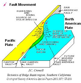 This area is located in what is called the
Ridge Basin. The Ridge Basin formed in the Late
Miocene and
Early
Pliocene
(~ 11 million years ago to ~4 million years ago). At that time
most of the movement on the San Andreas Fault system occurred
on the right lateral transform San Gabriel Fault, which is
less than a mile to the east The San Gabriel Fault is not
exactly straight (just as the San Andreas is also not
straight). As a result, there are areas that push up against
eachother creating hills and other areas are pulled apart
creating depressions or basins. The green area in the figure
represents the basin that was created in this area. It is is
about 24 miles long, 6 miles wide and about 8 miles deep and
has been named the Ridge Basin .
This area is located in what is called the
Ridge Basin. The Ridge Basin formed in the Late
Miocene and
Early
Pliocene
(~ 11 million years ago to ~4 million years ago). At that time
most of the movement on the San Andreas Fault system occurred
on the right lateral transform San Gabriel Fault, which is
less than a mile to the east The San Gabriel Fault is not
exactly straight (just as the San Andreas is also not
straight). As a result, there are areas that push up against
eachother creating hills and other areas are pulled apart
creating depressions or basins. The green area in the figure
represents the basin that was created in this area. It is is
about 24 miles long, 6 miles wide and about 8 miles deep and
has been named the Ridge Basin .
 One of the first rock formations that was
deposited in the Ridge Basin was the Castaic Formation. The
Miocene
Castaic Formation began its deposition as a transgressive
sequence on top of the
Paleocene
San Francisquito Formation forming an unconformity (see
Castaic Unconformity).
One of the first rock formations that was
deposited in the Ridge Basin was the Castaic Formation. The
Miocene
Castaic Formation began its deposition as a transgressive
sequence on top of the
Paleocene
San Francisquito Formation forming an unconformity (see
Castaic Unconformity).
In geological terms, a
transgressive
sequence marks the rise of sea level. This could be due to the
land sinking or the ocean levels rising. A transgressive sequence
is recognized by sandstone overlain by shale overlain by
limestone.
At a shore, the sands are deposited at the beach where the waves
are high energy, silt (which becomes shale) is deposited in the
near shore where there is still sediment, but the wave energy is
not high enough to bring large grains out that far, and further off
shore, limestone is deposited as the skeletons of diatoms in the
ocean fall to the ocean floor. When the ocean level rises, what was
the shore becomes the near shore, so the shale is deposited ontop
of the former beach sand sediments and the off shore moves to where
the near shore was depositing limestone on top of the shale. An
animation of this process is shown here
http://www.wwnorton.com/college/geo/egeo/animations/ch5.htm.
Here the oldest beds are non-marine and river sandstones
interlayered with marine sandstone with fossilized shells. On top
of the marine sandstone are shale beds indicating a general
increase in the depth of the water the formation was deposited
in.
The exciting feature here is a ridge of sandstone with quite a
few fossilized impressions of
pectens
and other marine fossils. Pectens are a species of shellfish that
are shaped like scallops (or the Shell gas station symbol). They
live along the shoreline in waters a few feet deep to deep
water.
The ridge continues around to the east and then starts curving
south. Pectens can be seen all along the ridge such as at N34
36.247 W118 39.743
Logging requirements:
Send me a note with :
- The text "GC1VK9E Castaic Formation Transgression and Pectens"
on the first line
- The number of people in your group.
- How big are the Pecten impressions?
- What kind of rock are the Pectens impressions in?
- Sandstone (you can see the grains)
- Shale (dark, thin-layered rock where you can’t see the
grains)
- Limestone (light gray rock with no grains or
layering)
The following sources were used to generate this
cache:
- Link, M.H., and Crowell, J.C., 2003, Guide to
field stops, Ridge Basin, southern California, in Crowell, J.C.,
ed., Evolution of Ridge Basin, southern California: Aninterplay of
sedimentation and tectonics: Boulder, Colorado, Geological Society
of America Special Paper 367, p. 205–247. © 2003 Geological Society
of America
- The Burke Museum of Natural History and Culture
– Marine Fossils and their Relatives – Scallops
http://www.washington.edu/burkemuseum/collections/paleontology/marine/scallops.php