
The Vikos-Aoos National Park (Greek: Εθνικός Δρυμός Βίκου-Αώου Ethnikós Drymós Víkou-Aóou), founded in 1973 is a national park in the periphery of Epirus in northwestern Greece. The national park encompasses 126 square kilometres (31,135 acres) of mountainous terrain, with numerous rivers, lakes, caves, deep canyons and dense coniferous and deciduous forest. The core of the park is the spectacular Vikos Gorge, carved by the Voidomatis river, while Aoos gorge, mount Tymfi, with its highest peak Gamila 2,497 metres (8,192 ft) and a number of traditionally preserved settlements form the park's peripheral zone.
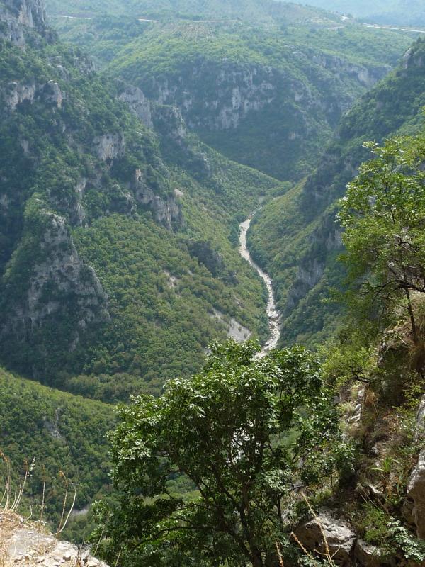
The Vikos Gorge, with a length of 20 km (12 mi), walls that range from 450 m (1,476 ft) to 1,600 m (5,249 ft) deep, and a width from 400 m (1,312 ft) to some meters at its narrowest part, is listed by the Guinness Book of Records as the deepest canyon in the world in proportion to its width, though some gorge lobyists contest that claim.
Geology
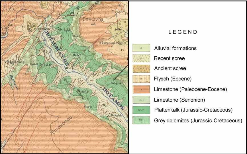
The area belongs to the Inner Ionian zone and is dominated by hard limestone of various geological age. The subalpine zone and the upper slopes of the gorge at a depth of about 400 m consist of the relatively young Eocene limestone . Limestone of the same geological era constitutes the slopes around Vicos village as well. Downwards to the gorge the previous layers are succeeded by a 200 m stratum of limestone of the Senon era, while the middle and lower slopes at a depth of about 700 m are consisted of Jurassic and Cretaceous limestone. Finally, at the deepest layers and up to an altitude of 500 (700) m, grey Jurassic dolomite dominates.
A special feature of the limestone, resulting from its chemical weathering to water, is its carstic nature. Limestone dissolves easily as the water percolates through its pores, so that an extended underground drainage system is developed with caves and channels that enlarge with the time when their roofs collapse producing rocky exposures and perpendicular slopes in the form of Vikos gorge. For the same reason the water is scarce in such a landscape, and only when an impenetrable stratum is met, the water appears on the earth surface.
The flysch, a sedimentary formation of alternating sequences of sandstones, shales, marls and clays is of limited extend in the study area. It is found near the village of Vikos, in an area where terraces were established there in the past to provide the necessary land for agriculture. Flysch covers an extensive area western of the National Park. Finally, a narrow interrupted strip of alluvial land is located along Voidomatis River. The land was also cultivated in the past due to the water availability. Nowadays it is abandoned because of the remoteness from the village.
VIKOS – geological map
To log this cache you must answer the following questions:
- What are two main minerals from VIKOS Gorge?
- What is chemical formula of limestone?
- On coordinates N 39.52.922, E 20.44.947 you find inform board. „How many hours does it take to PAPIGO through VIKOS CANYON”?
Please to your log add a picture of yourself with GPS with the board „Guiness book 1997“.You can log immediately after sending your answers. If something is not correct, we will contact you.
Small recommendation: Follow the way from head coordination, you find small church, then follow board „ To Grand cave n - Spitakia – Old Bridge“ and you can hunt the other cache – GCWRBJ
Used source: www.wikipedia.org, Despoina Amanatidou - Analysis and Evaluation of a Traditional Cultural Landscape as a basis for its Conservation Management - A case study in Vikos-Aoos National Park - Greece
More information:
http://en.wikipedia.org/wiki/Vikos_Gorge
http://en.wikipedia.org/wiki/Vikos-Aoos_National_Park
http://www.greecetravel.com/hiking/vikos.html
http://www.greeka.com/epirus/zagoria/zagoria/zagoria-vikos-gorge.htm#

Φαράγγι του Βίκου
Από τη Βικιπαίδεια, την ελεύθερη εγκυκλοπαίδεια
Μετάβαση σε: πλοήγηση, αναζήτηση
Το Φαράγγι του Βίκου, βρίσκεται 30 χλμ. βορειοδυτικά των Ιωαννίνων και είναι το βαθύτερο φαράγγι παγκοσμίως, σύμφωνα με το βιβλίο Guinness. Αποτελεί τον πυρήνα του Εθνικού Δρυμού Βίκου-Αώου, στην περιοχή του οποίου βρίσκει καταφύγιο μεγάλη ποικιλία σπάνιων ειδών χλωρίδας και πανίδας.
Το φαράγγι του Βίκου από τη θέση Μπελόη.
Το φαράγγι έχει μήκος 20 χλμ. και σε πολλά σημεία του το βάθος ξεπερνάει τα 1.000 μέτρα. Ο παραπόταμος του Αώου, Βοϊδομάτης, που το διατρέχει, έχει νερό μόνο εποχιακά.
Ο Βίκος δημιουργήθηκε μετά από έντονες γεωλογικές ανακατατάξεις κατά τη διάρκεια των γεωλογικών εποχών. Τα πρώτα ίχνη ανθρώπινης δραστηριότητας στην περιοχή έχουν εντοπισθεί από το 40.000 π.Χ.. Η χλωρίδα που συναντάται στη περιοχή του φαραγγιού είναι ιδιαίτερα μεγάλης ποικιλίας. Χαρακτηριστικά, μέχρι και τις αρχές του 20ου αιώνα τα βότανα του φαραγγιού χρησιμοποιούνταν από πρακτικούς γιατρούς, τους λεγόμενους «Βικογιατρούς» για θεραπευτικούς σκοπούς.
Το Φαράγγι του Βίκου αποτελεί δημοφιλής διαδρομή περιηγητών, η διάρκεια της περιήγησης για μία έμπειρη ομάδα δεν διαρκεί πάνω από 5 ώρες, προσφέροντας μοναδικές εικόνες. Από το χωριό Βραδέτο (θέση Μπελόη), όπως και από τη θέση Οξιά η θέα προς το φαράγγι είναι πανοραμική.
Στην περιοχή του φαραγγιού απαγορεύεται αυστηρά οποιαδήποτε ανθρώπινη δραστηριότητα έχει σχέση με κτηνοτροφία και φυσικά η υλοτομία.
Για να βρείτε αυτή την κρύπτη, πρέπει να απαντήσετε στις εξής ερωτήσεις:
1. Ποιες είναι οι κύριες δύο πηγές στο φαράγγι του Βίκου;
2. Ποια είναι η χημική σύσταση του ασβεστόλιθου;
3. Στο σημείο με συντεταγμένες N 39.52.922, E 20.44.947 υπάρχει πινακίδα με πληροφορίες. Ζητάμε την απάντηση στην ερώτηση: ’Πόση ώρα απέχει το Πάπιγκο μέσω της κοιλάδας του Βίκου’;
Παρακαλώ να προσθέσετε στο log μια φωτογραφία με εσάς κρατώντας τη συσκευή GPS μπροστά από την πινακίδα ‘Βιβλίο Γκίνες 1997’.Μπορείτε να δηλώσετε αυτή την κρύπτη αφού μας στείλετε τις απαντήσεις σας. Αν κάτι δεν είναι σωστό θα επικοινωνήσουμε μαζί σας.
Μικρή συμβουλή: Στην πορεία από τις αρχικές συντεταγμένες προς την πινακίδα, βρίσκεται ένα μικρό εκκλησάκι. Εκεί υπάρχει πινακίδα ‘Προς Μεγάλη Σπηλιά, Σπιτάκια – Παλιά Γέφυρα’. Προς τα εκεί βρίσκεται κρυμμένη άλλη κρύπτη με τον χαρακτηριστικό κωδικό GCWRBJ
Thanks to YANNIG for translation.