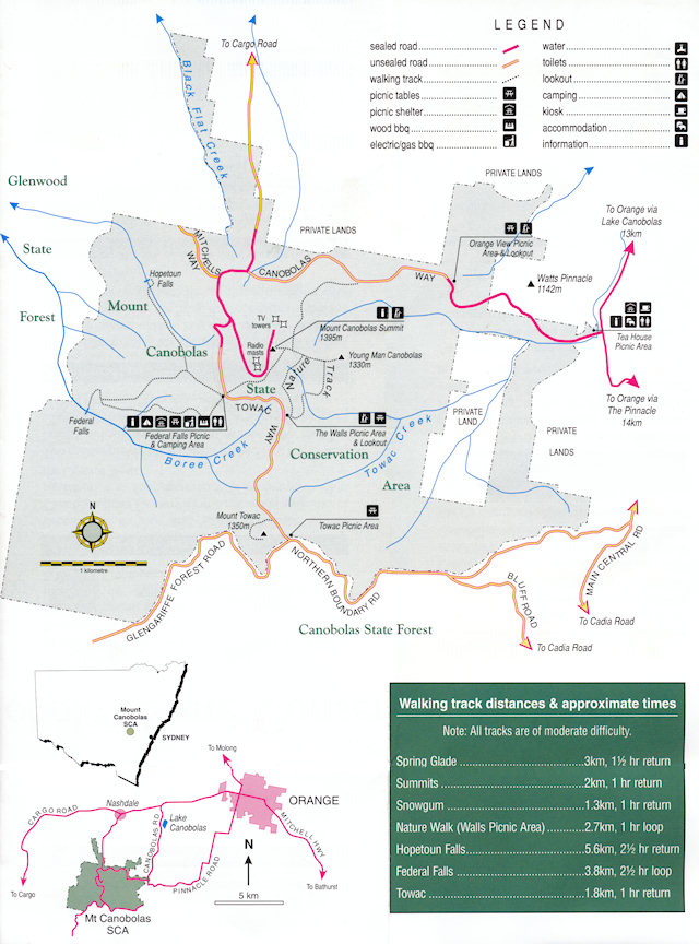
Further information on visiting the area can be found at Mount Canobolas State Conservation Area
Mount Canobolas State Conservation Area is located about 15 km south west of Orange in the central west of New South Wales. It is 1,672 ha in size, roughly square in shape and is approximately 6 km long and 5 km wide.
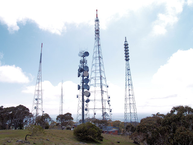
Mount Canobolas is an extinct volcano and is an important icon to the city of Orange and surrounding districts. It dominates the landscape and is an important tourist destination. The mountain’s prominence has attracted a considerable amount of telecommunications infrastructure including air safety, telecommunications, radio and television transmitters.
The commanding views from the summit of Mount Canobolas look out over the rich agricultural country of the central west tablelands and slopes.
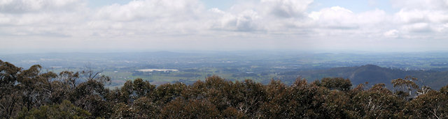
Mount Canobolas State Conservation Area contains a significant remnant of the vegetation which once covered this landscape and the views from the summit illustrate this dramatically.
Set amongst the largely cleared agricultural lands, other conservation reserves are visible from the summit. Barton Nature Reserve and Nangar National Park can be seen to the west, Mullion Range State Conservation Area is visible to the north, Conimbla National Park is visible to the south west and Winburndale Nature Reserve can be seen to the east.

Features of Mount Canobolas State Conservation Area
Landscape - Mount Canobolas and its surrounding peaks are an important landmark of the central west. The SCA is visible from all directions from up to 50 km away. There are 360 degree panoramic views from the summit of Mount Canobolas provide extensive views over the central west. The SCA also contains other landforms such as waterfalls, exposed rock platforms, dykes, domes and plugs.
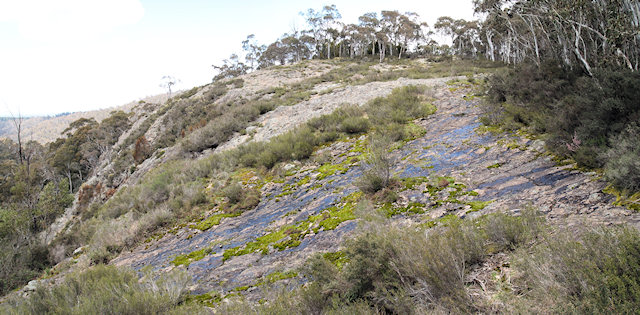
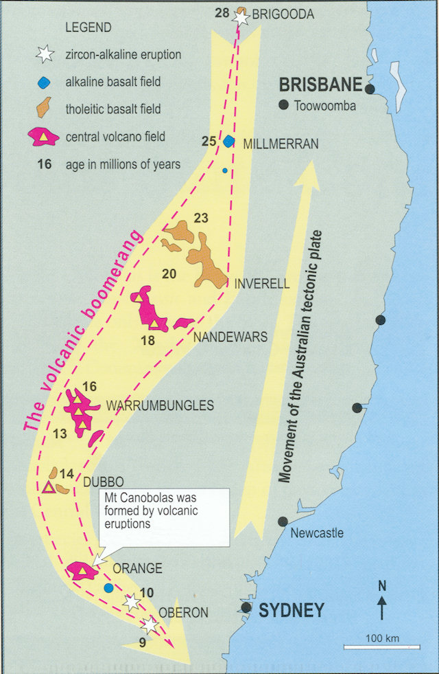
Geology - Mount Canobolas State Conservation Area has an interesting geological past. The SCA was formed by volcanic activity. Geological analysis indicates that Mount Canobolas is related to other volcanic landforms stretching in a chain from Oberon in the south to south east Queensland in the north. The most famous of these are the Warrumbungle Range near Coonabarrabran and the Nandewar Range near Narrabri. These areas of ancient volcanoes are conserved in the Warrumbungle National Park and Mount Kaputar National Park respectively.
Natural features - The native vegetation of the central west is highly fragmented. Only 25% of the original native vegetation cover remains across the region and much of this is in poor or declining condition. In this type of landscape, areas such as Mount Canobolas State Conservation Area are highly significant for conservation. Mount Canobolas State Conservation Area is an isolated high altitude remnant in relatively good condition. It contains one of the largest remnants of sub-alpine vegetation in the central west and a number of species which are poorly represented in the Central West. Most of the plant communities are at the north western limit of their known distribution and some of these communities are highly significant. A total of 305 plant species have been recorded, two of which are endemic to the reserve. Two species, (Eucalyptus canobolensis) and (Eucalyptus saxicola), are listed as threatened under the Threatened Species Conservation (TSC) Act 1995. The Xanthoparmelia lichen community found on the exposed rock ledges and outcrops is also recognised as an Endangered Ecological Community under the TSC. Five other plant species are considered significant because they occur in the SCA near the limits of their distribution or are restricted in distribution. Seventy-six fauna species have been recorded comprising 43 bird species, 11 reptile species, three amphibians, five ground dwelling mammals, five arboreal mammals, five micro bats and four introduced species.
Cultural heritage – A small number of occupation sites and stone tools have been recorded in the SCA but it is likely that, because of its prominence, the mountain was of significance to the Wiradjuri people.
Recreation and tourism – Mount Canobolas is a highly significant tourism and recreation resource in the central west. The 360 panoramic views from the summit are a major draw card to visitors from outside the region as well as locals. The mountain is considered an important tourist attraction by both Cabonne and Orange City Councils.
Scientific and educational values – The SCA is an important scientific reference site and presents opportunities for studies into natural ecosystem processes. The geological history of the SCA is of particular interest and has been the subject of scientific study in the past.
How to log this earthcache
To log this earthcache please:
- Take a photo of the view from the summit with you and/or your GPS in and post it in your cache log.
- Answer the following questions to help enhance your experience:
- How long ago was Mount Canobolas formed through a series of volcanic eruptions?
- The name Canobolas derives from which Wiradyuri words?
- What sort of rocks were left behind after the eruptions?
- These rocks erode and break down to form what?
- What does this underpin and nourish today?
- What is prising the rocks apart?
- What is breaking the rock surface down one grain at a time?
- What has allowed unusual lichens to exist on the mountain which aren't found in the surrounding countryside?
- What sort of volcanic rocks are valued for making stone tools?
- How high (in feet and metres) is Mount Canobolas? Hint: The two numbers are at different locations.
- The weather of Mount Canobolas supports what sort of forests?
- Who placed the plaque at the summit?
- How far is it to the Radio Telescope?
- Read more about the rocks in question 3 by going to Wikipedia and searching for the main article on this type of rock.
Acknowledgment:
This listing is predominantly extracted from the:
- MOUNT CANOBOLAS STATE CONSERVATION AREA PLAN OF MANAGEMENT, NSW National Parks and Wildlife Service, October 2003. Crown Copyright 2003. ISBN 0 7313 6554 2
- Mount Canobolas State Conservation Area Visitor Guide, NSW National Parks and Wildlife Service, Copyright NPWS April 2010.
Contacts
Park management office
Orange Visitor Information Centre
Cabonne Visitor Information Centres