INTRODUCTION
This Earth Cache is going to take you to a rock outcropping along Kepner Creek in Norristown Farm Park. Geologic focus will highlight sedimontology and stratigraphy.
To claim the find you are going to do some of the same skills a real field geologist may do.
REQUIRED MATERIAL
~ Magnetic Orienteering Compass
~ Writing Device (Pencil recommended)
RECOMMENDED MATERIALl
~ Walking Stick
Camera
~ Park Map
BACKGROUND GEOLOGY: STOCKTON FORMATION (TRs)
How did these rocks get here and when did this occur?
All the rocks within Norristown Farm Park belong to the Stockton Formation. The Stockton is upper Triassic in age which is approximately between 237 to 207 million years ago. The general interpretation of how these rocks were formed was streams eroded bedrock from ancient highlands to the southeast. These sediments filled into a depression known as the Newark Basin that was being created from the rifting (separation) of North America from Africa.
The gravel and sand deposited in theses ancient stream channels created the sandstones and conglomerates. While the finer silts and clays were likely deposited in the slack waters, on the stream banks, and in the flood plains creating the siltstones and shales we see today. This type erosional/depostional environment is known by geologist as a fluvial system.
Why are most of the Rocks Red?
The red color seen in the rocks can be explained by the presence of hematite and has been interpreted that when the sediments were being deposited this iron mineral was exposed with oxygen, then oxidized, and essentially created rust.
So what kind of rocks will I see?
All the rocks within the Stockton are sedimentary and are generally arkosic (feldspar bearing) conglomerate, arkosic sandstone, siltstone, and shale. You will observe that the dominant rock in the Kepner Creek are sandstones in the creek bed. Shale units are easily eroded and are often covered with vegetation however there is a small outcropping in the bank
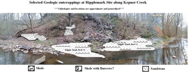
Ripple Marks Preserved in Stone: What am I looking at?
At the site you will notice two outcropping beds of rock going straight into the stream. The wavy surfaces represent ripple marks. These marks were actually created before the sediments were lithified (turned to stone).
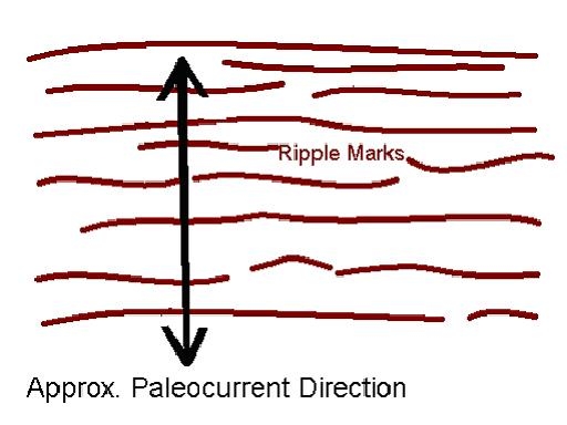
Ripple marks are important to geologist for a few reasons. They are one clue in the interpretation of the type of environment the rocks were created in. Certain types of ripple marks are made under only special environmental conditions and can sometimes help interpret ancient current directions. If the ripple marks make roughly parallel ridges you can measure an orientation with your compass that bisects these ridges perpendicularly. That orientation shows the preferred current direction of the ancient current that transported these sediments. This ancient current is called a Paleocurrent, and in specific situations a scientist may be even able to interpret which direction is down stream!
Furthermore, ripple marks are classified as a sedimentary feature which can help a geologist ID a rocks bedding plane from other geologic features such as joints and faults.
 <>/p>
<>/p>
SKILLS & FIELD REQUIREMENTS
1.One of the beds of ripplemarks you can ID the orientation of the paleocurrent. Using a stick or other elongate linear object, place it in line with the direction of flow. See above image.
2. Using your compass get the paleocurrents orientation*** and please e-mail your answer to the CO. If you are within the acceptable range you can claim your smiley.
*** I am going to assume that you, the cacher know how to use a compass. However I will highlight a very common mistake. Always keep your compass level. Your bearing can be significantly off elsewise. See photo below if you need further clarification.

If you do no know how to use a compass don’t fret there are plenty of good websites and other sources that can help you. Also for the sake of simplicity you do not have to worry about magnetic declination (Though a scientist would!).
If the compass is tilted you will not get an accurate reading!
THE GOLDEN BRUNTON COMPASS CHALLENGE
You do not need to answer these to receive credit. This is merely for those of you above and beyond people out there. p>
E-mail the CO the answers (Please give up to one week for response) 1. On the ripple mark surface that you measured the orientation, does the current seem to be going the same way every on this sample or is there local variances within the rock.
a. If so ID another current orientation.
2. Knowing that these ripple marks are made by a fluvial “stream/river” system. Would you expect ripplemarks found elsewhere in this rock unit to bear similar orientations. Explain your answer.
3. Does the direction of dip of the bedrock that these ripplemarks are found on determine the direction of the Paleocurrent. (Think about the order of geologic processes within time.) Briefly explain your answer.
4. The Stockton Formation is one of three major Triassic aged rocks found within the Newark Basin what are the other two formations?
REFERENCES
Berg, T.M., Map 61 - Atlas of Preliminary Geologic Quadrangle Maps of Pennsylvania 1981, Lansdale, Pennsylvania Geological Survey
The Geology of Pennsylvania: Special Publication 1, 1999, Pennsylvania Geological Survey & Pittsburgh Geological Survey, pg. 194,197, 440
Prothero et Schwab, Sedimentary geology: An Introduction to sedimentary rocks and Stratigraphy,2004,second edition, New York, pg. 46 - 49
http://en.wikipedia.org/wiki/Stockton_Formation
