Ag-rarian Amble (Dunedin, Otago) Traditional Cache
Ag-rarian Amble (Dunedin, Otago)
Please note Use of geocaching.com services is subject to the terms and conditions
in our disclaimer.
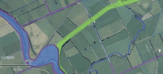
A flat and very easy walk along the true right Silverstream stopbank from Riverside Rd to the Taieri confluence. The round trip is just a bit over 2 km - ideal for children.
This stopbank is grazed, so be prepared for sheep or what they leave behind them.
The stopbank on both sides of the Silverstream is owned by the Otago Regional Council and has public access. (See the DCC rates map.) The gate at the start may be locked if stock are grazing the stopbank, but there is a gap at one side for people to go through. Apart from that obstacle, you'll have no trouble taking a stroller or biking right to the cache. You're looking for a 1 litre screwtop in the obvious hide. Please make sure you hide it completely. Leave gates as you find them and, needless to say, watch children near steep banks and water.

If you’d prefer a canter to an amble, start walking from The Alternative on Gladfield Rd. Or bike the entire length of the Silverstream stopbank from Wingatui Rd close to By The Babbling Brook.
As you can see from the Walking Access Map, at the time this area was surveyed the Taieri had a huge bend where the cache is hidden and therefore it’s all public land. You can find some nice places to paddle on a fine day, provided the river’s low. You can also walk along the Taieri riverbank, but check the WAMS map first- parts of the Taieri stopbank are private land.
The Silverstream’s source is up beyond the Raceman’s Track weir in the Silverpeaks. George Griffiths suggests the stream's name may have come from Hampshire or Kent, where Kettle was born. The original 1846 survey of the Taieri by S M Scroggs, our friend E I Abbott and J Tully, supervised by Kettle, showed the ”Silver Stream” running beside Mr Kettle’s own sheep station. In the 1850’s this property passed to Niel McGregor, who also leased the whole western catchment of the Silver Stream up to Mt Allen. His manager’s house was called “Silvermains” and it seems likely that McGregor gave the name Silver Peak to the summit of the Silver stream’s watershed.
The Maori name for the stream where it joined the Taieri below the large lagoon was Waiputaka, which Griffiths says means Paradise Duck Creek. Another name was Whakaehu, meaning turbid or muddy water. It was made by the taniwha Matamata, protector of the chief Te Rakitaounere. Apparently, Matamata got geographically embarrassed trying to catch up with Te Rakitaounere. He wriggled down the Silverstream and the Taieri, shaping the bends of the river as he went. When he died his body formed the coastal hills, Saddle Hill and Scroggs Hill.
The fields on either side of the Silverstream are part of the Upper Taieri Ponding Area. The sluicegate you'll see controls drainage from the ponding area. The stopbanks are designed to allow water to overflow on the true right first, at about 180 cumecs flow, so that Mosgiel township on the true left is protected. The biggest Silverstream flood in memory was 199 cumecs in April 2006.
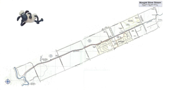 Map from Antony Hamel's "Dunedin Tracks and Trails"
Additional Hints
(Decrypt)
TY haqre fgbar, orgjrra byq tngr naq genpx, 1 z sebz arj tngr ng oevqtr.
Treasures
You'll collect a digital Treasure from one of these collections when you find and log this geocache:

Loading Treasures