Port Phillip Bay is a broad embayment that represents the final phases of infilling of what is termed a “sunkland”.
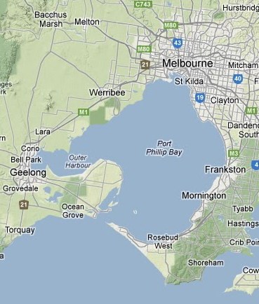
Large faults formed as Australia was separating from Antarctica, allowing a rhomboid shaped rock block about 100km across to settle downwards as the granitic crust was being stretched apart and broken. The main boundary faults are the Selwyn Fault to the southeast, which runs through Frankston southwest to Cape Schanck, and the parallel Rowsley Fault running southwest through Bacchus Marsh. A sharp downwarp in the rocks along a northwest trending line through Melbourne marks the northern side of the sunkland. Smaller faults mark the southern side near Geelong.
Drill hole evidence indicates that this depression became an open marine embayment, surrounded by rocky uplands early in Tertiary times. Younger basalts have filled much of the area to the east of Bacchus Marsh to the shoreline of the bay.
The present enclosed form did not develop until the late Pleistocene, when calcareous dune sands accumulated east of Geelong, as the Nepean Peninsular. Only a small opening, 3.2 km wide at high tide, is left into the bay, with a strong tidal rip through this entrance. The modern outlines of the bay were established around 6,000 years ago as the sea flooded the embayment, forming the present beaches and tidal flats.
The present bay is generally 9 to 24m deep, except for The Rip at the entrance, where tidal scouring has eroded the bed to 60m depth.
Seismic probing has shown that the bay sediments overlie the Tertiary sequences and also a series of old buried river channels that flowed southwards from the mouth of the Yarra River and Kororoit and Werribee Creeks, towards the Mornington Peninsular. These channels were active before 10,000 years ago when the sea levels were much lower. (See earthcache GC3MB9N)Some of the sands from these rivers may have been blown onto the primitive Nepean Peninsular, because the age of sands recovered there during drilling matches the age of these channels.
Most of the modern day fill is up to 27m thick, filling the old channels and overlying the old land surface.
The sediments have accumulated at around 0.4mm per year, most of it in the last 6,500 years.
(Source: The Geology of Australia by David Johnson)
At the lookout, you will find a sign showing a panorama of the southern section of the bay, looking towards The Rip, and which explains some aspects of the geology of the bay.
Requirements for Permission to log a Find on this Earthcache.
Note: It's quite okay to log an earthcache find immediately, so that your order of finds is preserved, but I must receive your answers with a week to ten days, or your log may be deleted.
-
What is the leftmost feature you can identify in the view from GZ.
-
Describe in your own words, some geological processes which could effect changes in the average depth of the bay.
-
NOW MANDATORY: Please attach a photo to your found log, of some aspect of the view with yourself, or a personal item, included in the photo.
-
Please send your answers to me at earthcaches@jamieson.id.au This email address goes directly to my phone and I can usually respond immediately.
Of course you can also contact me through my geocaching profile, but the response may take considerably longer.