|
EDUCATIONAL LOGGING REQUIREMENTS
In order to substantiate your visit and be able to claim this earth cache you have to submit your answers to the following questions to the cache developer via e-mail:
1) Explain in your own words why Dwyka diamictite is exposed as a broken ring across South Africa. Clue: think about how it was deposited and how it is now exposed on a new continent (or more generally a layered cake cut diagonally down).
2) Why are many of the inclusions in the diamictite protruding from their mud matrix?
3) What is a joint and why do they play such a big role in what these rocks look like?
4) What are tafoni?
5) The photo below was taken from GZ on the flat rock just north-north-east of the highest rock “layer” in the area. You’ll notice a drilled hole in the eastern, vertical side of this “layer”. Please identify and describe the geological feature ~800mm to the left (SE) of this hole; obscured by the red circle in the photo below.

6) Optional: Please share your experience with the caching community by uploading photos of the landscape, any geological features at the site you found interesting and/or your caching party with your log.
|
OVERVIEW
This earth cache will bring you to a beautiful beach with a fascinating and rare intertidal zone exposure of a rock formation which is a lot of fun to explore because it is as strikingly beautiful as it is interesting. Visiting the site during low tide will give you access to more areas to explore.
In the description below I’ll first set the context by discussing the physical geology and origin of the featured rocks and then continue to focus on why these rocks are looking like they do today. I’ll also refer to the other Dwyka Group related earth caches in South Africa to consolidate some of the most relevant information to help you develop a complete picture of this Group, its characteristics and place in South Africa's geological history.
This is really an amazing spot with interesting geological features and a beautiful, quiet beach so bring your sarmies and suntan lotion and spend some time here – you’ll love it!
WHAT THESE ROCKS ARE
The rocks exposed at GZ are diamictite, a sedimentary rock that originates from terrigenous (formed on land) sediments of poorly sorted clasts in a fine mud matrix. It is easily recognisable as unstratified (no layers), dark bluish-grey mudstone that contains many inclusions of older rock types dispersed through the mud matrix (also referred to as xenoliths; photo below). Typical sedimentary origins of diamictite include submarine landslide deposits and glacial till (sediment directly deposited by a glacier).

The diamictite exposed here is part of the Dwyka Group (Carboniferous), the first layer of the Karoo Supergroup sediments. It is also commonly called Dwyka tillite in South Africa even though it does not always meet the strict definition of tillite. In most cases it is in fact not lithified till, but rather sediment deposited in liquid water in a glacially-influenced basin as discussed below. In general, the non-prejudicial name “Dwyka diamictite” is therefore more accurate.
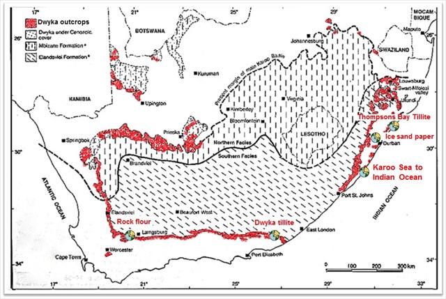
The Dwyka group is exposed in a thin, broken ring right across South Africa (indicated in red in the map below), in general delineating the transition from older formations on its outside to the younger Karoo Supergroup on its inside. The Dwyka Group is the subject of at least four other earth caches:
Near Matjiesfontein in “Rock flour” you’ll see natural surface exposures clearly illustrating Dwyka diamictite’s "tombstone weathering" character, while at “Dwyka tillite” on the N2 east of Grahamstown, you can have a peek “inside” relatively freshly exposed Dwyka diamictite in a road cutting. At “Ice sand paper” you can examine striations on Natal Group sandstone, which were caused by the same glaciers that produced the sediments which eventually formed these rocks. Finally, at “Thompsons Bay Tillite” you can also see a Dwyka exposure on a beach, but which looks remarkably different from these Ifafa exposures. The Thompsons Bay rocks have clearly been deformed and have sharper edges, suggesting that it is a more recent exposure and/or a harder formation. This conclusion is also supported by the presence of many protruding inclusions, indicative of differential weathering over a long time, and honeycomb weathering in the Ifafa exposure, while these are absent at Thompsons Bay.
WHERE THESE ROCKS CAME FROM
Approximately 330 to 290 million years ago (MYA - the Permo-Carboniferous era) what we now know as Southern Africa was part of the super continent Gondwana (which also included South America, India, Antarctica and Australia) and it was migrating over the South Pole Region (map below). At this stage the Cape Fold Mountains also grew so large that their weight caused a depression in Earth’s crust, resulting in a large inland basin between the Cape Fold Mountains and the Cargonian Highlands in the north - the Karoo Sea.
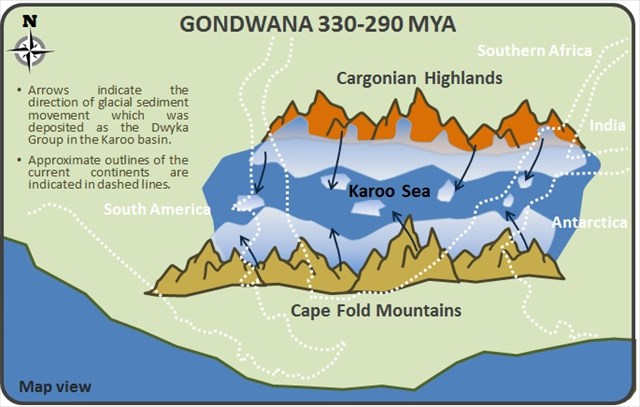
Due to its proximity to the South Pole, the area was also covered by a major ice sheet that of course caused a lot of glacial erosion in the mountain ranges bordering the Karoo Sea (see cross-section below). As the continent slowly migrated north into a warmer climate the ice sheet and glaciers started to melt and their associated sediments were subsequently deposited in the Karoo basin as the Dwyka Group - the oldest and lowermost unit of the Karoo Supergroup that is recognised throughout sub-Saharan Africa. As the Karoo Sea covered an area larger than just the current Southern African sub-continent, similar diamictites of the same age are also present in South America, Antarctica and even India - a fact that is recognised as one of the key pieces of evidence supporting the continental drift hypothesis.

As Gondwana continued to drift north over the next ~50 million years, the subsequent sedimentary layers of the Karoo Supergroup, e.g. the Ecca and Beaufort Groups, were deposited in increasingly warmer climates. The change in climate and long time period did not only influence the types of sediments that were deposited, i.e. first swamp and sandy shore associated sediments then predominantly river sediments that formed the shales and sandstones of these two groups, but also the abundance and types of fossils that are associated with these consecutive rock groups.
WHAT’S CURRENTLY HAPPENING TO THESE ROCKS
Another fascinating aspect you will be able to explore at this site is the weathering/erosion of these rocks in an intertidal zone.
Rocks are brittle, so they crack when subjected to stresses, but they crack in a very particular manner/pattern depending on the nature of their crystalline structure/mineral composition and the specific stress. Sometimes cracks form between the molecules of the minerals in a rock without the slightest movement, resulting in a crack so small you can’t see it with the naked eye - these microscopic cracks are called joints. Jointing can occur as a body of rock is uncovered by erosion (unloading joints), deformed (tectonic joints) or exposed to temperature fluctuations (cooling joints). Joints, even at this molecular level, create exposed surface areas that facilitate weathering and subsequent erosion along them, resulting in characteristic erosion patterns in jointed rocks.
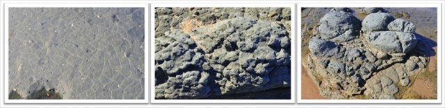
Diamictite is well jointed. When it is exposed to weathering, the joints will first become visible as line patterns on the surface of the rock (photo below left) and as preferential weathering and erosion continues along the joints, it will result in a rock with a spheroidal appearance (photo below middle). On a larger scale, this gives rise to seemingly repetitive, protruding rocks that are often referred to as “daggers” or “tombstones” when exposed as rocky outcrops on a hillside or as rounded "boulders" at this site (photo below right and also see “Rock flour”).
As diamictite weathers it also passes through various distinct stages that differ in colour and hardness as the chemical composition of the rock changes. During the first stage it turns from dark blue-grey to a hard, olive-brown rock, which subsequently becomes softer and a lighter yellowish-brown colour. Completely weathered diamictite forms yellow-brown clay. These different stages of weathered diamictite can be clearly seen as thin “sheets” and along the large, eroded joints in the rocks at this site (photo below), which could easily be mistaken for a secondary deposit of a different sedimentary rock type – or even lava flow!
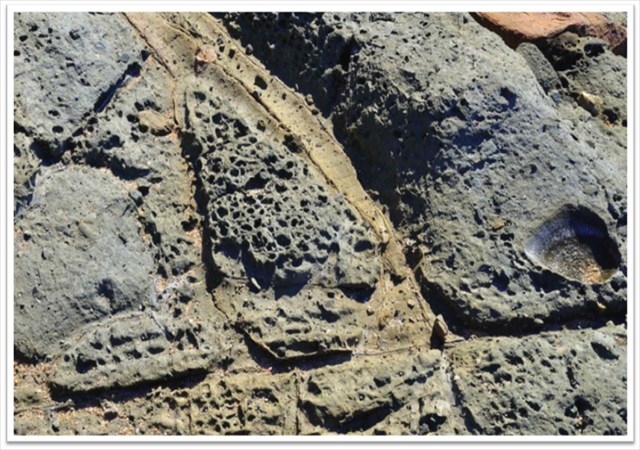
Finally, the site also gives you a unique opportunity to explore one of the interesting features caused by salt weathering. You’ll notice many areas of the exposed rocks are covered with natural, ellipsoidal, pan- to bowl-shaped cavities (photo below). These cavernous weathering features are called tafoni, which could be tiny pits like you see here or as large as car-sized caves. Tafoni typically have rounded entrances and smooth concave walls and they often occur in groups to form fascinating features referred to as honeycomb rock. This type of weathering is referred to as fretting, tafoni-, honeycomb-, stone lattice- or cavernous weathering. It can be found in all climate types, but is most abundant in intertidal zones and semi-arid and arid deserts in granular rocks such as sandstone, limestone and granite. In diamictite, pits that are caused by honeycomb weathering should not be confused with moulds that are left behind when inclusional rocks fall out of the mud matrix (see large mould on the right hand side of the photo above).
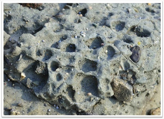
For honeycomb weathering to occur, a source of salt is needed because the basic mechanism for this kind of weathering is salt heaving. Dissolved salts are deposited on the surface of the rock by saltwater spray or by mist – the moisture is important to allow the dissolved salts to first settle on the rock and then flow into the tiny pores (e.g. joints) of the rock. When the water subsequently evaporates the salts will crystallize within the pores, causing the salt crystals to pry apart the mineral grains, leaving them vulnerable to other forms of weathering and erosion. It takes prolonged periods for this weathering to become visible, as the rock has to go through repetitive cycles of wetting and drying.
ENJOY exploring this fascinating area and the beautiful beach!
REFERENCES
McCarthy T & Rubidge B (2005). The story of earth & life: A Southern African perspective on a 4.6-billion-year journey.
Visser JNJ, Von Brunn V & Johnson MR (1990). Dwyka Group. In: Catalogue of South African lithostratigraphic units.
http://clasticdetritus.com
http://www.tafoni.com
*******************************************
