Note: For all you Earthcache lovers out there, here's another one nearby! Alluvial Dumping Ground
To log this cache, use the following info, your surroundings and intellect to answer the following questions. Email me the appropriate answers (don't post them in your log, or per Earthcache guidelines your post will have to be deleted), and most of all, have fun!
- Does the river below exhibit any entrenched meanders? Explain why / why not.
- Identify and describe at least one (1) other identifying clue / landform of the river below which proves the Sevier River is a "meandering river" based on the info above.
- (Optional): What is an oxbow lake? Do you see any evidence of any here (or where one might have once been)? Explain.
- (Optional, but STRONGLY encouraged
 ): Take and post a picture of yourself and / or the river below.
Note that to log this cache, you will NOT be looking for a typical geocache container (in fact, there IS no container to find). Rather, to prove you were here and learned something you'll need to find the answers to the given questions (found at the end of this description), which you will then email me, the owner (this is the same process for ALL Earthcaches).
So go ahead and log your experience while here, submit photos, etc., but email your answers to me (not in your visit log) to get credit for "finding" this cache. If it seems too complicated, don't sweat it too much (as long as I can see that you made an honest effort to answer all of the questions, that is fine). Remember that the purpose of this is to learn something, and most importantly, to have fun! Also, feel free to email me with any questions you may have, I'd be happy to help.
Note: this cache was placed with Assistant Park Ranger Evans' help & permission. The area is free to access, and should be accessible by car, although an off-road vehicle would be easier. Do take care not to head down the bluff, as the area below is private property.
Meandering Rivers
When a river first forms (often in the mountains), it flows fast and cuts downward. Once it reaches the valley floor, the water will spread out a bit more and slow down (this part of a river is called the "middle course"); in the Sevier River's unique case, the middle course starts just after being released from behind the nearby dam. You may notice the river then begins “meandering” (in other words, wandering back in forth, somewhat like a snake) which happens as an equilibrium is reached between the effects of friction and inertia on the flow of water and the water's tendency to follow the shortest path and steepest gradient (i.e. decline or slope).
Generally you will find many rivers with actively evolving meanders (i.e. meandering rivers) in wetter, flat areas of the country, while they are more rare in drier areas like Utah. There are however some notable examples of ancient meandering rivers in Utah throughout the Colorado Plateau, like Glen Canyon or the San Juan River for example. These rivers illustrate what are called "Entrenched Meanders"; you'll notice that such rivers' meanders are deeply incised / entrenched, and therefore no longer migrating like the ones you see here at this site.
This phenomenon occurred on the San Juan River as a result of the established valley floor's slope being suddenly raised due to tectonic uplift, and the resulting increase of gravity's downward pull created increased river flow, thus allowing the river to more rapidly erode away the land beneath it, effectively preserving in time the shape of meanders of the river at that time, millions of years ago. A more detailed example and description of this process can be found at the following earthcache located at the Goosenecks of the San Juan River: An Entrenched Meander.
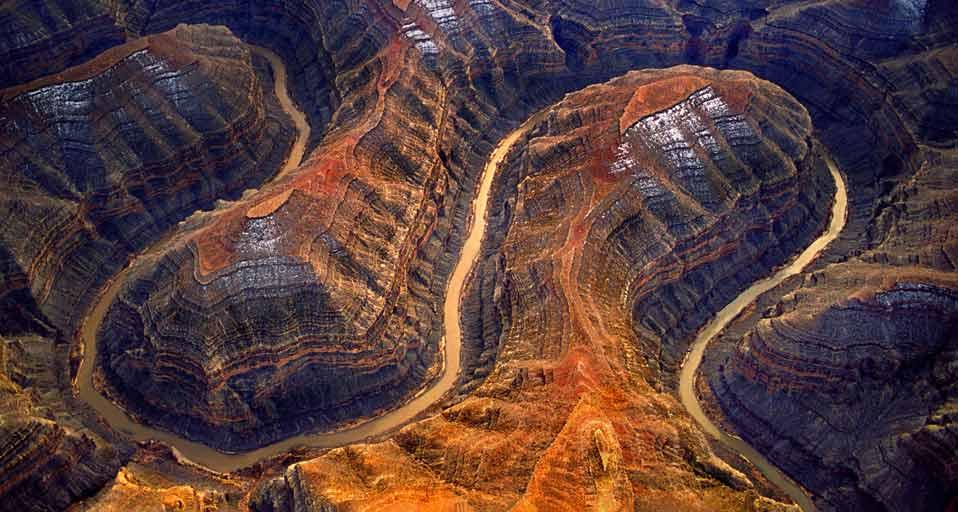
Above: Note the deeply incised cuts of the above photo of the San Juan River.
This particular stretch of the Sevier River, despite not having a huge decline to rush down, still has plenty of energy and often a high volume of water. As the gradient / or decline in the middle course by this point is gentle, lateral or sideways erosion most often occurs, versus the steep and ‘v’ cutting erosion that often occurs in streams / rivers with a sharp gradient / decline, like those mentioned above with entrenched meanders. As the river erodes laterally, to the right side then the left side, it forms large bends, and then gradually horseshoe-like loops called meanders. The formation of these landforms is due to both deposition and erosion, and as a result of this geologic process, meanders will gradually migrate downstream.
With some meandering rivers in wetter areas or areas with higher watertables, you will often see backswamps as well as perhaps a yazoo stream, like in the diagram below, though these are not really present at this location due to the arid climate. Bluffs demarcate the floodplain, or the lower valley area surrounding the river, where the meanders will migrate, from the higher uplands that have not been eroded by the rivers path.
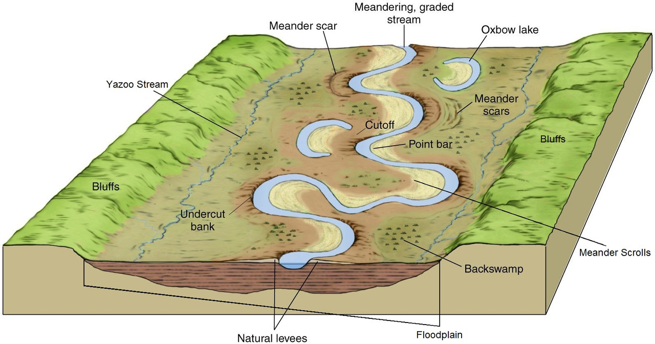
Above: Diagram of a meandering river and associated landforms.
The force of the water erodes and undercuts the river bank on the outside of the bend where water flow has the most energy due to decreased friction. This action often creates sharp cliffs called cutbanks or undercut banks (see diagram above).
On the inside of the bend, where the river flow is slower, material is deposited along the banks of the river, creating landforms that are called point bars. As there is more friction at that point, suspended material eroded away earlier, like small particles such as sand, silt, tiny pebbles, etc, is left behind as the water slows around the inside bends along these point bars.
Over time, these point bars will add layer after layer, making the meanders wider and wider, and you can often see the older point bar depositional layers away from the river, in landforms that are known as meander scrolls,which are visible hills / layers that have often become overgrown with vegetation, but still can be identified as former point bars.
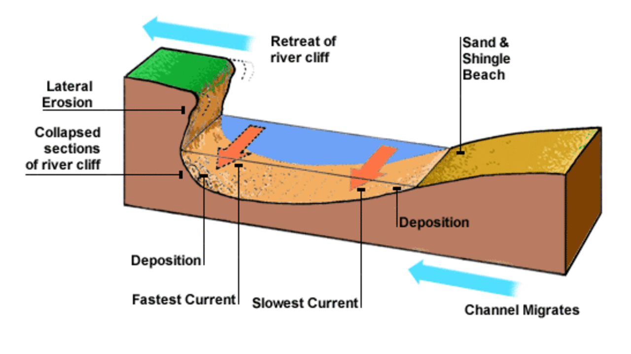
Above: Cross-section diagram of a meander.
Eventually the horseshoes become tighter, and the bends grow wider with bigger and bigger point bars, until the ends become very close together. As the river breaks through (for example during a flood when the river has a higher discharge and more energy) and the ends join, the loop is cut-off from the main channel. These cut-off river loops are a type of landform called an oxbow lake.
Note that whenever the river does overflow its banks into the floodplain, it will leave deposits along the edge of the river, forming natural levees, or banks of sand, small pebbles, etc. These levees can also help identify old river channels when the river changes course, as they often do with a meandering river.
Oxbow lakes
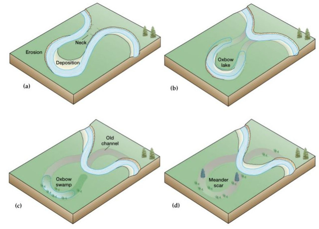
Above: Diagram of the formation of an oxbow lake.
In the pictures above (a-d), upstream a large bend / meander becomes a horseshoe and is eventually cut-off to become an oxbow lake. Downstream the river continues eroding its outer bank and depositing on its inner bank to create a new meander. The creation of oxbow lakes is a common part of meandering river systems, and thus merits its own description.
Meanwhile, once these lakes are cut off from their source of water (barring lots of rainfall or a very high water table), many oxbow lakes dry up and first become oxbow swamps, then finally meander scars, which though they have no water, still show where the old river channel(s) once ran. If you look carefully, you can often see indications that identify them as such, like raised levees along the former river banks, meander scrolls that show old depositions of point bars, etc. As the river continues to flow, this process often repeats itself many times within meandering river systems.
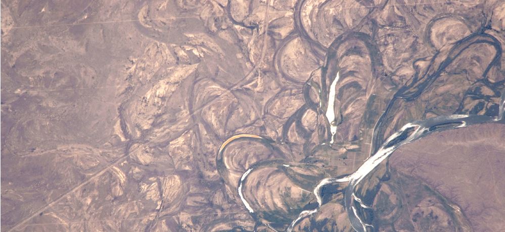
Above: Note the many other former river channels seen in this satellite image of the Rio Negro River in Argentina
In conclusion, remember: to log this cache, use the preceeding info, your surroundings and intellect to answer the following questions. Email me the appropriate answers (don't post them in your log, or per Earthcache guidelines your post will have to be deleted), and most of all, have fun!
- Does the river below exhibit any entrenched meanders? Explain why / why not.
- Identify and describe at least one (1) other identifying clue / landform of the river below which proves the Sevier River is a "meandering river" based on the info above.
- (Optional): What is an oxbow lake? Do you see any evidence of any here (or where one might have once been)? Explain.
- (Optional, but STRONGLY encouraged ): Take and post a picture of yourself and / or the river below.
| I have earned GSA's highest level: |
 |