This Earthcache will bring you to a location were this "Failure" is just beginning to show and teach you the evolution of Slump Block Failure! A newly visible geological event such as this - yet accessible to the public - is a rare find! For the END RESULT of this process see nearby "Slump Blocks" Earthcache.
From parking, allow 2+hrs for the 3.3 mile round trip over Mesa Top Trail, improved, fairly level, for hike, bike, & horse. Insect spray & hiking boots a must with 2 mud-bogs to cross on stepping stones
Not required, but a review of the info in Grand Mesa’s Cap - GC5D5FT and Slump Blocks – GC5DGGP will help your understanding of the processes at work here.
The slump blocks surrounding Grand Mesa appear to have resulted from retrogressive rotational failure, a type of mass movement that occurs when landslides enlarge opposite to their direction of movement by slumping of successive blocks from the mesa edge. Blocks of relatively rigid cap rock** have been transported by sliding in the underlying claystone. Individual blocks moved by rotation and translation. Rotation accounts for backward tilting of the blocks (Yeend, 1969) and translation (forward movement/slippage) accounts for much of the separation between them. . . . . . Slump blocks below the rim of Grand Mesa exist in practically all stages of their evolution, from incipient slumps that have moved less than a meter to old, degraded slumps that have moved hundreds of meters from their original positions and have subsequently been weathered and eroded. U.S.G.S. “GEOLOGIC MAP OF SLUMP-BLOCK DEPOSITS . . . (etc)” Open-File Report 96-017 By Rex L. Baum & Jack K. Odum.
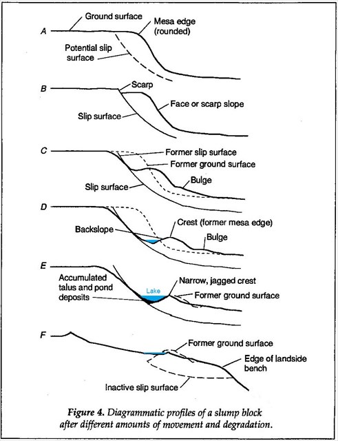
Attached is a sketch of the various stages of slump block failure (taken from the article above)
In addition to parking, several waypoints have been provided with this web page. They are as follows:
“Descent into failure” N39 00.671 W108 03.097
The “Bowl of Failure” is at the given GZ coordinates.
“Bench of Failure” N39 00.481 W108 03.300 - just a few yards beyond GZ
As you approach the “Descent –“ you will notice a slight down slope of the trail as you cross a water shed course. As you continue on to GZ, note the ridge that forms to your right. You are now in the failure zone.
On arrival at GZ you will be in a semi-circle of boulders, (the “Bowl of Failure.”) These are a former part of the cap rock** which have fallen off of the scarp above as the earthen “block” you are standing on “slumps” lower & lower and support of the cap is lost. This is called "mass wasting."
**The cap rock is basalt (a form of lava), very dense and usually full of little air pockets known as vesicles.
West an additional 125 yds is the last waypoint. Note that you are now on a narrow “Bench” with the ridge to the North. The entire area is sliding downslope with a rotating motion outward at the base.
A “Slump Block” is born!
As you wander around between the "bowl" and the "bench" look carefully at where the "bench" intersects the "up slope", this is the fault line of the failure. Notice all the dead trees lying across and around the fault line? It is thought that possibly exposed cap rock and lack of top soil at the fault line has caused this massive die off of trees as their roots were torn and exposed! No one knows for sure as finding a failure at such an early stage is rare and tree die off such as this has never been observed.
Note that many of the dead trees have barely begun to rot, evidence that this is recent!
Most of the Slump Blocks along the sides of Grand Mesa are much more massive and wider – thousands of feet! They are also eons older and are the end result of the "Failure" you see beginning here. As they rotate, the outer edge becomes higher than the inner edge creating what is referred to as “backslope” which eventually traps water and becomes a lake, another of the 300+ lakes for which Grand Mesa is famous!
You may log your find immediately but to complete the process you must answer the following questions and e-mail them at the same time to TEAM kekj . Please do not post the answers in your log: It will be deleted!
1. From Fig. 4 above, which of the various stages shown (A - F) best describes the area you are at.
2. Estimate how much the “block” has “slumped” from the ridge above. Is this early or late stage failure?
3. Describe the color & size of the boulders in the “Bowl of Failure”, do you believe they are basalt? Why?
4. Describe the width of the “Bench”, how does this compare in size to other "benches" along the slopes of Grand Mesa, Larger? Smaller? why do you think this is? (Go look over the edge for help on this one! What is not far down below? Another . . . .??)
We would like to acknowledge the support of the rangers at the Grand Mesa National Forest Visitor Center, in particular the resident geologist, Mike Wiley, who first showed us the diagram above, specifically pointed out this location to us as an excellent learning location, and then answered our questions about what we were seeing!
Congrates to valhikes for a second FTF on one of our earthcaches on the same day! 6-25-15