To log this Earthcache, you will NOT be looking for a typical geocache container (in fact, there IS no container to find). Rather, to prove you were here and learned something you'll need to find the answers to the given questions (found below as well as at the end of this description), which you will then email me, the owner (this is the same process for ALL Earthcaches).
So go ahead and log your experience while here, submit photos, etc., but email your answers to me (not in your visit log) to get credit for "finding" this cache. If it seems too complicated, don't sweat it too much (as long as I can see that you made an honest effort to answer all of the questions, that is fine). Remember that the purpose of this is to learn something, and most importantly, to have fun! Also, feel free to email me with any questions you may have, I'd be happy to help.
To log this cache, use the info below, the info board found at the coordinates, your surroundings and observations to answer the following questions. Email me the appropriate answers (don't post them in your log, or per Earthcache guidelines your post will have to be deleted), and most of all, have fun!
- How does channelization affect flooding? Does it really solve the problem?
- As you observe the area now, describe what you see (river flow, erosion processes at work, wetlands, plant and wildlife, etc.). What would have been different when this was a channelized river?
- What geological benefits do naturally meandering streams and the surrounding wetlands / floodplains have, compared to channelized rivers? Any other benefits?
- (Optional): According to the information board at the posted coordinates, what percentage of wildlife uses the riparian habitat that results from a naturally meandering river? List any such animals that you might (or did) see (or found evidence of) while here today.
- (Optional): Take and post a picture of yourself and / or the river below.
Introduction
To the NW of this spot, as you look out across these wetlands and at the meandering Provo River and adjoining Snake Creek, with its plentiful wetlands, habitat, blue ribbon fishing, etc., it’s easy to assume that it has always been this way for 1000s of years. Sadly however, this river was very different for several decades; starting in the 1940s thru the 1960s, the locals with help from federal authorities ‘improved’ and channelized the river (i.e. made straight, instead of the meandering natural flow you now see) and dredged (i.e. the bottom deepened / scooped out to increase the river’s flow) it, along with several damming projects (first Deer Creek Reservoir, completed in 1941 and later Jordanelle Reservoir, completed in the 1990s) and numerous diking / embankment projects.
Why Change the River?
Human beings have modified rivers for centuries, and the reasons have usually been to manage the water resources, to protect against flooding, or to make passage along or across rivers easier. However, in recent years, our understanding of rivers has increased such that we now realize that in spite of human beings’ best efforts, rivers naturally do a better job of managing themselves when left alone and unmodified.
Channelization is one of the most recent ways that humans have tried to manage and control rivers, putting them in neat, straight paths with dikes on each side to keep the water inside and flowing, sometimes even encasing the sides of the channel in concrete to lessen erosion. This in theory decreases the chance of flooding, and helps dry out surrounding wetlands for development. However, this channelization has also proved to be one of the more destructive things we could do to a river.
 Nature Knows Best
What hydro engineers didn’t fully comprehend at the time they embarked on their quest to control the Provo River was that by channelizing the river, and drying out the wetlands, they were disregarding the best tool they had to control floods: the natural floodplain! Floodplains are natural flood control systems. A river with a healthy floodplain almost never sees floods outside its boundaries. The flood plain, true to its name, floods most years. However, this does no harm if it is expected. The extensive wetlands in the floodplain dampen the effects of the flood. In fact, floods are actually beneficial in these areas. The ancient Egyptians farmed the floodplains of the Nile every year during the dry season, and left the area during the floods. The result was a thick layer of fertile silt deposited on their fields every year. The Aswan Dam was built in the 20th century to curtail natural floods. Now, the farmers can farm the nearby land all year long. However, the fields are increasingly infertile and unproductive and the poor farmers are forced to buy massive amounts of expensive fertilizer every year to get the production they need.

Floodplains have many benefits; as the Egyptians can tell you, floodplains are extremely fertile land, if allowed to continue their natural flood cycle. Although they make excellent farmland, floodplains are even more productive when left to themselves. In addition to dampening floods and providing fertile soil, floodplains provide excellent wildlife habitat. Although this is implicitly a good thing, it also offers many benefits for humans. For example, trout are much more abundant in rivers with lush floodplains. trout are a very tasty fish, and often the vast abundance of trout in a river with a floodplain makes up for the economical losses of not draining the wetlands and subsequently farming the land (though farming as the Egyptians did would still be possible). Other fish also abound in these areas. In addition, recreational uses for the land such as boating, hiking, hunting, camping, etc., are much more fulfilling in a non-channelized river.
Floodplains, as noted earlier, dampen floods. They also lessen the effects of droughts by creating a vast network of natural water storage in wetlands and groundwater areas. These areas also filter most pollutants out of the water, making the river more useful to anything living nearby, including humans, who have in recent years also realized wetlands' inherent value and even begun utilizing them as natural filters and storage for water.
Impact on Stream and Floodplain Processes and Functions
Once they have been channelized, straight streams tend to shoot water like a fire hose. When the bends and curves (meanders) are removed, the stream continues to drop the same elevation, but over a shorter linear distance. This increases the slope of the channel, which in turn increases the stream’s velocity. Note that the meanders, riffles, pools, and floodplains of a natural stream channel provide resistance that dissipates the stream’s energy. Without these features, the stream has more energy to use eroding its bed and banks. Often, the stream will cut into its bed, causing large steep eroding slopes. This process will continue until the stream can reach the equilibrium that was present prior to channelization.
Erosion
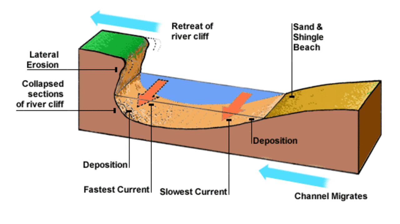
In a meandering river or stream, erosion naturally occurs (see diagram above) at the outside of meander bends in a stream channel, while deposition of eroded material occurs on the inside curves. This happens because the channel flow is fastest on the outside bend of the stream, and on the inside of the bend the flow is slowest. Such meandering rivers and streams will often have sharp banks on outside of such bends, where rapid erosion is present. Meanwhile, on the inside bank you'll often see sandy deposits that have developed as well, showing the deposition of material.
This does not suggest however that straightening a channel will eliminate erosion problems— quite the contrary. Straightening a stream will result in a shorter, steeper channel, in which water moves faster and has more energy. This change often upsets the balance of the stream, causing erosion, loss of land, increased sediment supply, loss of aquatic and riparian (i.e. river) habitat, or other problems.
 Impact Elsewhere
Channel straightening is sometimes proposed to address flooding or erosion problems. The premise is often that a straight, smooth channel moves the water through faster, so less is available to spill out onto the floodplain. Erosion problems are addressed by moving the main flow away from the eroding bank, which is frequently located on the outside of a bend. Although straightening or relocating a stream may provide relief at a specific location, it drastically alters the stream flow characteristics and may cause additional problems both upstream and downstream of the project site. This is because the channel-straightening project tends to focus on one stream function—water transport—without adequately accounting for other functions, such as energy dissipation and sediment transport. Confining flow to a paved channel may have flood conveyance benefits to the immediate area. However, habitat is lost and downstream areas will be impacted. One solution to the increased erosion potential of a straightened stream is to protect the bed and banks with rock or concrete. This smooth, hard channel enables the water to speed through even faster, taking its energy with it. Downstream areas will have higher peak flows, because the water gets there faster, which just increases flooding problems. In addition, downstream areas will be subject to increased erosion as well.

Results
As you can probably guess, the channelization of the Provo River led to all of these issues. Flooding downstream increased dramatically, the native trophy-winning trout population was obliterated, and many acres of rare riparian wildlife habitat and forest were lost. In the 1990s, the local and federal governments realized the damage they had caused, and involved themselves in a new project to correct the damage: The Provo River Restoration Project. After over a decade of work and over $45 million dollars, they worked to restore the Middle Provo River close to its natural state, from Jordanelle Reservoir to Deer Creek Reservoir. It may take many more decades for this section of the river to fully return to the state it once was, but at least it is well on its way.
In conclusion, remember: to log this cache, use the above info, the info board found at the coordinates, your surroundings and observations to answer the following questions. Email me the appropriate answers (don't post them in your log, or per Earthcache guidelines your post will have to be deleted), and most of all, have fun!
- How does channelization affect flooding? Does it really solve the problem?
- As you observe the area now, describe what you see (river flow, erosion processes at work, wetlands, plant and wildlife, etc.). What would have been different when this was a channelized river?
- What geological benefits do naturally meandering streams and the surrounding wetlands / floodplains have, compared to channelized rivers? Any other benefits?
- (Optional): According to the information board at the posted coordinates, what percentage of wildlife uses the riparian habitat that results from a naturally meandering river? List any such animals that you might (or did) see (or found evidence of) while here today.
- (Optional): Take and post a picture of yourself and / or the river below.
This cache was created by an
