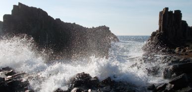
The Bombo Headland Quarry (near Kiama) is an historical part of the NSW South Coast. Its geological, aesthetic and social aspects provide so much to the local community, with its stunning cliffs, prehistoric rock formations and the amazing vista making it a popular spot with locals and tourists who come to watch the waves crash on the rocks or walk along the coast, but it’s also used for various commercial settings such as television commercials and other promotions activities almost on a weekly basis. The unique columnar features of the place are often referred to by local children as “Toothbrush Island”. The neighbouring beaches, surfing spots and fishing draw crowds from far and wide.
Geology
Millions of years ago volcanism formed basaltic lava flows in the region, these flows played a significant role in shaping Australia’s southern coastline. Today the Bombo Headland is one of the most significant geological sites in New South Wales, its rock type and its formation features have technical significance to international scientists as it was formed when north and south magnetic poles were reversed. The headland consists of two rock types of the Gerringong volcanics, the Kiama Sandstone rock and the Bombo Latite rock, which were deposited about 260 million years ago during the early Permian period. Around 60 to 25 million years ago further volcanic activity created another layer of Basalt (Bombo Latite), which is overlayed on the headland. The later volcanic activity intruded the Bombo Latite in the form of dykes. The Kiama Sandstone rock has formed a narrow platform adjacent to the vertical cliff faces around the south-eastern extremity of the headland.
Basalt in the Headland
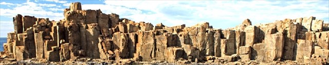
Basalt is a dark-coloured, fine-grained, igneous rock composed mainly of plagioclase and pyroxene minerals. It is most commonly formed as an extrusive rock, such as a lava flow, but can also form in small intrusive bodies, such as an igneous dyke or a thin sill. Within the headland there are examples of extrusive and intrusive formations due to the overlaying over various volcanic activity, if people know what they are looking for up to 5 dykes can be found while exploring the quarry. The main feature of the headland is the spectacular columnar jointing which is caused during the cooling of the thick basalt lava flows. The lava contracts as it cools, forming fractures/cracks, once a crack develops it continues to grow resulting in what you see in front of you. These columns and jointing are evident throughout the quarry with the isolated columns adjacent the ocean up to five metres in height. Much of the columns were left standing when the quarry was excavated to keep the sea out of the quarry. At the northern end of the wall cross sections of the columns result in a 'Giants Causeway' appearance.
Volcanic Breccia
To the untrained, volcanic breccia can often be mistaken as sedimentary conglomerate, the main difference being the type of rock and how they look. Conglomerate is composed of rounded fragments of pre-existing rocks while volcanic breccia is formed by the explosive volcanic eruptions trapping wall material in magma which results in fragmented rocks being entrapped in the flows. Lava may also pick up rock fragments, especially if flowing over rubble on the flanks of a volcano and this can also form volcanic breccia.
Volcanic Dykes
A dyke is an igneous intrusion formed when magma cools and solidifies before it reaches the surface. The magma pushes up towards the surface through cracks in the rock. Dykes form vertical or steeply in the rock and the dyke is always younger than the rocks which surround it. Dykes are usually visible because they are at a different angle and usually have different colour and texture to that of the rock surrounding them.
Kiama Sandstone
Seeing sandstone along the the eastern seaboard of Australia isn’t uncommon, however its surprising to see this unique feature of sandstone layered into a basalt headland. Geological history tells us that sandstone is prevalent to the region but in an area known for is volcanic activity it’s rare to see the two rock types together. The headland offers a great example of the two rocks as much of the sandstone in the area is normally below sea level except for a small narrow wave-cut platform visible from the quarry. A mixture of lava (basalt) and sediment like this is called peperite.
Mining the Basalt
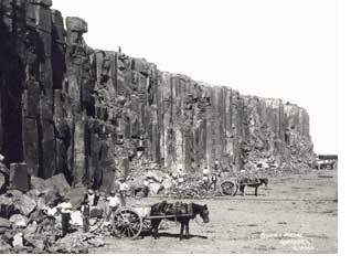
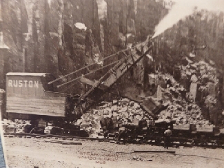
In 1880 James Holt received a parcel of crown land in the Bombo area, soon afterwards the Bombo Headland Quarry commenced operation for the quarrying of blue metal. By 1883 a jetty was erected north of the headland. Steam crushing machines and equipment were installed and rail services were extended from Sydney to Kiama, including a spur into the quarry. The quarry and its transport ship SS Dunmore were operated by NSW Associated Blue Metal Quarries Ltd. The transportation of basalt to Sydney became known as the ‘Blue Diamond Trade’ and the dozens of small vessels carrying the blue metal became known as the ‘Stone Fleet’. Railways in the area in the late 19th Century reduced the reliance on shipping for transporting the blue metal and provided a more effective means of transportation. In 1930 the quarry closed for five years during the depression, by 1935 the quarry reopened and electric crushers and machines were installed. However in 1940 NSW Railways ceased quarrying at Bombo Headland and moved operations to the quarry on the western side of the railway line which is still operational today. Regrettably none of the mining history remains on site, the old tramway, jetty and crushers have all gone.
To claim a find on this earthcache
You won’t find any information boards giving you the answers so don’t attempt this cache unless you’re prepared to do a bit of research and look around the site. Take care in this area as the ocean is unpredictable and the ground can be loose and uneven. Visit each waypoint where you will obtain the answers to the questions which are listed in the additional waypoints.
Log your find and email your answers to me via my profile. If there are any issues with your answers I will contact you. Logs without emailed answers will be deleted.
References:
https://www.sydneywater.com.au/SW/water-the-environment/what-we-re-doing/Heritage-search/heritage-detail/index.htm?heritageid=4572730&FromPage=searchresults