I admit, I'm quite the slacker. I've been searching for a year to find something that met my criteria of what I thought a Virtual Cache should be. We'll let it be said, I failed. There were just so many interesting sites I've come across over the years that I couldn't decide. I had a few back-up sort of mundane ideas coupled with a few ideas for the Dolly Sods area, but I just couldn't make my mind up.
I then, after describing my possible locations, asked wvhunter what I should pick. He said "What about that one where we could see forever after visiting the caches at Jennings Randolph Lake?" (Or something closely to that.) Walla....here we are. The Pinnacle Knob Lookout Station
I've spent some time trying to find information on the origin of the lookout and this is the best I could do so far.
www.wvencyclopedia.org informs us The development of the fire tower network was a result of disastrous forest fires that swept the Mountain State following the cutting of the original virgin forest. The first fire towers were erected in 1916. These wooden structures had two floors. The first floor was the living quarters for the observer, and the second floor served as an observation room. With the advent of taller steel towers separate living quarters were provided, usually a small cinder block or log building adjacent to the tower. The first steel tower was built on Backbone Mountain near Parsons by Emory N. ‘‘Pop’’ Wriston in 1922. During the spring and fall months, when fire danger was most severe, observers scanned the area around them for the first sign of fire.
When a tell-tale plume of smoke appeared above the horizon, the observer relayed the information to a nearby district forestry office. Each tower contained a circular map of the surrounding area. By sighting along an alidade or fire finder, an observer could quickly take a bearing on the smoke. By comparing the readings from two or more towers one could pinpoint the location of the fire where the readings intersected on the map. This method is known as triangulation. Fire fighting crews were then dispatched to the scene to suppress the fire.
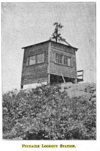
Although there's nothing left of the original, wooden station, and only the stairs, foundation and framework of the second lookout building, the view from here is the real treasure.
During the summer months just about any vehicle can make it here. Winter months better be higher clearance AWD/4WD because of the snow.
ALSO...Snakes, there be snakes. No big deal since this is a virtual and one won't be searching in the rocks, but be forewarned.
PHOTO LOGGING REQUIREMENTS: I've seen many different requirements so almost anything goes, but must include part of the remaining steel structure. (Oops, it appears the steel structure is gone. How about using some of the concrete in the pic instead.) You. You and your GPS/Phone, Your GPS/Phone and hand/arm, or something (family friendly) with your caching name written on it.
Virtual Reward - 2017/2018
This Virtual Cache is part of a limited release of Virtuals created between August 24, 2017 and August 24, 2018. Only 4,000 cache owners were given the opportunity to hide a Virtual Cache. Learn more about Virtual Rewards on the Geocaching Blog.