“Few places in this world are more dangerous than home. Fear not, therefore, to try the mountain passes. They will kill care, save you from deadly apathy, set you free, and call forth every faculty into vigorous, enthusiastic action.” - John Muir
Our general location is blessed with several areas of backcountry, hinterlands if you will, that are within easy driving distance of all of the local city-scapes. These areas of solitude, which can be traversed only by hike, will bring you to cascading waterfalls, gorgeous iron-infused springs, grottos, balanced rocks, slump blocks, pine forests, caves, ledges, arches, and above all places that will save you from the slow death that is provided by our addiction to technology. This virtual cache will take you away from landscapes created by concrete and gold and move you toward landscapes created by father time and mother nature.
Time eventually robs us of our physicality so there is none to waste. This cache will take you to 10 locations over the course of a 4-5 mile loop (depending upon your route) and you will end at the same parking lot from which you began.
Since 2013, my caching time has dwindled as my family has continued to grow older, but my time in the backcountry has increased significantly. I have traipsed across hinterlands from Maryland to Nevada, I’ve stood under Delicate Arches in Utah, camped with desert scorpions, stood on ledges above the Colorado River on the north and south rims of the Grand Canyon, stood atop 14,000 foot peaks in Colorado, and watched my youngest son struggle with altitude sickness while chasing mountain goats. Eventually, however, I always end up back here. What you'll find on this hike rivals anything in the midwest and although it's not as big as the Hocking Hills Region, it feels about the same geologically. Luckily for us the hinterlands found in this hike and virtual cache are ever present and waiting for your footsteps within a short easy drive of your location in southwestern Ohio.
Cache details:
The posted coordinates are for the parking lot. As stated above, the total hike distance for logging this cache is a loop of approximately 4-5 miles and you should plan on following the waypoints in the following manner to make an efficient loop; Q1, Q2, Q3, Q4, Q5, T1, Q6, Q7, T2, Q8, T3, Q9, and 10. Plan on rocky uneven terrain and plan on having wet feet. There will be a mild amount of elevation gain on a couple of occasions, and in true hinterlands fashion, there may be a couple of areas where the trails get overgrown in the summer because of a lack of foot traffic. This hike takes place on well maintained trails and won’t require bushwhacking. Although there are 10 locations to visit, logging is required at only 5 of the locations (pictures are encouraged, however, at all locations). Logs that do not provide the appropriate virtual cache documentation will be deleted according to the rules of virtual caches. There has to be proof that you were there, which is why photos with you in them are great, but virtual cache guidelines say that a face can't be required. Come prepared to do a good bit of real hiking. Come prepared to take at least 5 pictures. This cache is set up in the tradition of the original virtual caches, taking you to places that shouldn't have physical containers and require some work to get there while providing you with extraordinary landscapes and geologic beauty. Enjoy this bit of backcountry and don't look at it as a chance to rack up numbers. Consider this cache as an adventure, an opportunity to make memories in the real world that no virtual machine can match.
The logging requirements are listed below as waypoints, but I'll list them all here for clarity. Each virtual stage with cool stuff is listed as Q1 - Q9. Virtual stages that are simply waypoints to keep you from getting lost in the myriad of trails in the Glen as you hike the loop are listed as T1 - T3. You will notice that all logging requirements are found in red below. Pictures are required at locations Q1, Q4, Q5, Q6, and Q8 as described below. Virtual stage number 10 requires an answer to be sent to me through messages or through email - please do not post the answer to virtual stage 10 in your log. If you do post it, I'll delete your log and shoot you a message or email to let you know that you should log it again minus the answer. Because there is no physical log, I won't hesitate to delete logs that do not provide the required documentation - this virtual is all about the adventure.
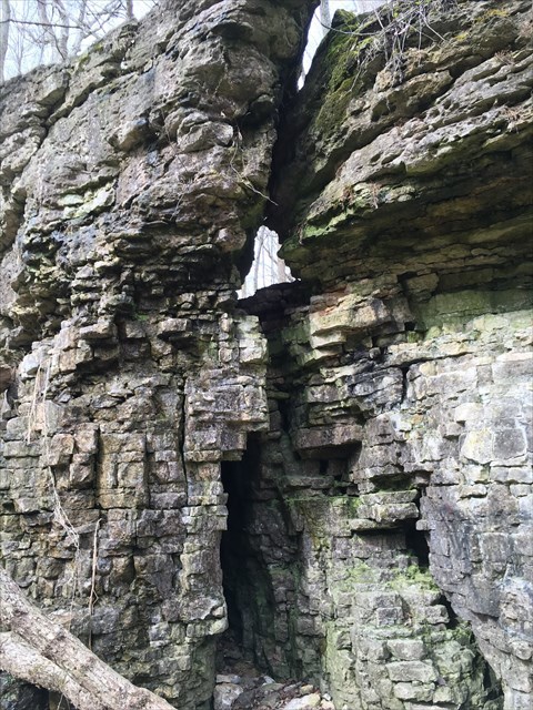
Q1 - Baby Arch - Required picture including you with the object
Q2 - The Grotto - Optional picture with the object
Q3 - Orange Springs - Optional picture with the object
Q4 - The Cascades - Required picture including you with the object
Q5 - Slump Block Arch - Required picture including you with the object
Q6 - The Pines - Required picture including you with the object
Q7 - Secret Springs - Optional picture with the object
Q8 - Waterfall Terrace - Required picture including you with the object
Q9 - The Pillar - Optional picture with the object
10 - Count the number of steps as you ascend to the top landing (plaque of Lamar Inman) and message or email me the answer
On a personal note, both of my children have graduated college now. My wife is only occasionally involved, so I have transitioned from “Bernoulli and family” to “Devil Winds”, which is what the Shawnee used to call the area in which I live as a result of the windstorms and tornadic activity that frequent the area. I’m hoping to see many of you back on the trails again and I appreciate those cachers who have helped me maintain some of my caches in the intervening time period when I was unable to get to them
Virtual Reward - 2017/2018
This Virtual Cache is part of a limited release of Virtuals created between August 24, 2017 and August 24, 2018. Only 4,000 cache owners were given the opportunity to hide a Virtual Cache. Learn more about Virtual Rewards on the Geocaching Blog.