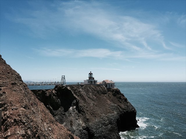
Built in 1855, Point Bonita Lighthouse was the third lighthouse constructed on the West Coast. It was a vital addition to the Bay Area, designed to keep thousands of eager Gold Rush settlers and explorers safe. However, the location of the original brick tower actually turned out to be too high, so the light was often obscured by dense fog and couldn't be seen from the water.
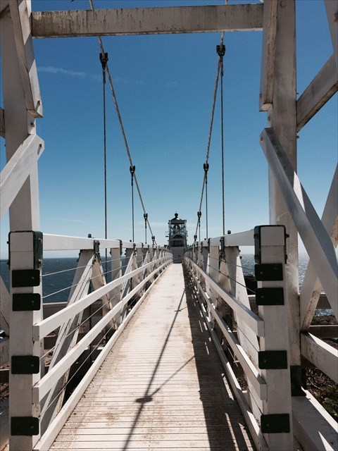
In 1877, the lighthouse was moved to its current location, down from 306 feet to 124 feet above sea level, but that introduced new challenges. Years of erosion eventually caused the trail to the lighthouse to crumble into the sea, so builders then had to carve an access tunnel by hand straight through solid rock. Point Bonita Lighthouse is now the only one in America that is reached by crossing a suspension bridge, which was first built in 1954, closed and repaired multiple times for rust damage, and ultimately reopened in 2012 -- a new bridge constructed from tropical hardwood with steel cables for over $1 million.
Sadly, many of California's lighthouses have fallen into disrepair due to costs, permanently closed, or rendered obsolete by GPS technology. Fortunately, with its electric fog horn and mariner radio activated sound signal (MRASS), Point Bonita Lighthouse is still active today and part of the largest urban national park in the U.S., the Golden Gate National Recreation Area. When mariners need the signal, they can activate the MRASS by using channel Alpha 82 and keying their mic five times, which will turn on the signal for 30 minutes. The light is maintained by the U.S. Coast Guard, and the National Park Service cares for the signal building itself and provides access to visitors.
The United States Lighthouse Society also offers a fun passport club that allows you to collect stamps as you visit lighthouses around the country, and many of those locations also have geocaches! Point Bonita Lighthouse's stamp is located at the Marin Headlands Visitor Center, NOT the lighthouse itself.
PLEASE NOTE!
As of April 13, 2025, The Point Bonita Lighthouse trail and tunnel are open Sundays and Mondays, 12:30 pm to 3:30 pm, but the suspension bridge is closed indefinitely. Visitors can access the viewing platform but cannot enter the lighthouse or cross the bridge. On Sundays and Mondays, ranger/docent led "light chats" take place prior to opening at 12:15pm at the entrance to the Point Bonita Trail outside the tunnel. When visiting, no reservation is required, and visiting the site is free of charge. Last entry through the tunnel leading to the lighthouse is at 3:20pm *sharp*, so please arrive plenty early to ensure you are able to visit!
It does sometimes close for weather, events, or other reasons, so it’s best to call the Marin Headlands Visitor Center at 415-331-1540 or email GOGA_MarinHeadlands_info@nps.gov to confirm before making the trip. No dogs or bikes are allowed on the trail or at the lighthouse. It can be surprisingly cold and extraordinarily windy, so dress appropriately. The lighthouse is about a half mile walk from the main parking area, and the path is quite steep in some areas. Parking is very limited.
TO LOG THIS CACHE:
You will need to visit the location and take a picture, which you can send to me or post with your log. You can't see the lighthouse from the parking lot; if you don't visit during visiting hours, you can try to photograph from other spots in the headlands. The picture MUST include:
(1) Yourself
(2) Point Bonita Lighthouse in the background
Virtual Reward - 2017/2018
This Virtual Cache is part of a limited release of Virtuals created between August 24, 2017 and August 24, 2018. Only 4,000 cache owners were given the opportunity to hide a Virtual Cache. Learn more about Virtual Rewards on the Geocaching Blog.