TD 042 - The Murrumbidgee EarthCache
TD 042 - The Murrumbidgee
-
Difficulty:
-

-
Terrain:
-

Size:  (other)
Please note Use of geocaching.com services is subject to the terms and conditions
in our disclaimer.
This is an Earthcache, so there is no cache container at the listed co-ordinates!
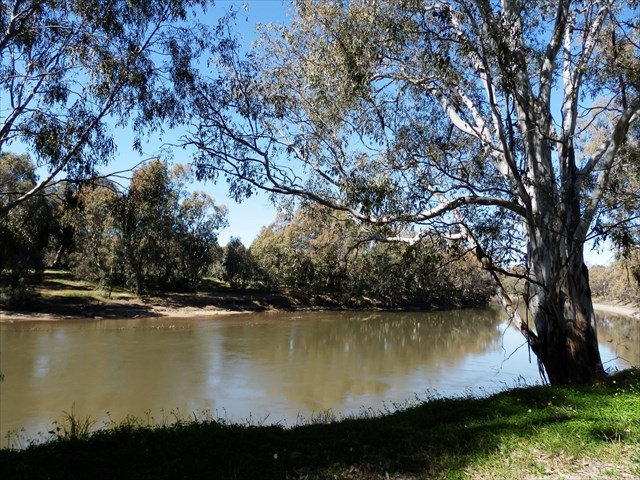
This earthcache takes you to the banks of the Murrumbidgee River.

The Murrumbidgee River
A major tributary of the Murray River within the Murray–Darling basin and the second longest river in Australia. It flows through the Australian state of New South Wales and the Australian Capital Territory. It descends 1,500 metres as it flows 1,485 kilometres in a west-northwesterly direction from the foot of Peppercorn Hill in the Fiery Range of the Snowy Mountains towards its confluence with the Murray River near Boundary Bend.
The word Murrumbidgee means "big water" in the Wiradjuri language, one of the local Aboriginal languages.
The River Processes:
Erosion, Transportation and Deposition
There are three main types of processes that occur in a river. These are erosion, transportation and deposition. All three depend on the amount of energy there is in a river.
* Erosion
Types of erosion
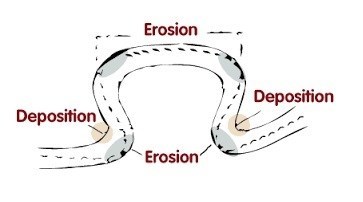
The energy in a river causes erosion. The bed and banks can be eroded making it wider, deeper and longer.
Headward erosion makes a river longer. This erosion happens near its source. Surface run-off and throughflow causes erosion at the point where the water enters the valley head.
Vertical erosion makes a river channel deeper - this happens more in the upper stages of a river. Lateral erosion makes a river wider - this occurs mostly in the middle and lower stages of a river.
There are four main processes of erosion that occur in rivers. These are:
1. hydraulic action;
2. abrasion / corrasion;
3. attrition; and
4. corrosion.
Hydraulic action
The pressure of water breaks away rock particles from the river bed and banks. The force of the water hits river banks, and then pushes water into cracks. Air becomes compressed, pressure increases and the riverbank may, in time collapse. Where velocity is high e.g. the outer bend of meaner, hydraulic action can remove material from the banks which may lead to undercutting and river bank collapse. Near waterfalls and rapids, the force may be strong enough to work on lines of weakness in joints and bedding planes until they are eroded.
Abrasion / Corrasion
The sediment carried by a river scours the bed and banks. Where depressions exist in the channel floor the river can cause pebbles to spin around and turn hollows into potholes.
Attrition
Eroded rocks collide and break into smaller fragments. The edges of these rocks become smoother and more rounded. Attrition makes the particles of rock smaller. It does not erode the bed and bank. Pieces of river sediment become smaller and more rounded as they move downstream.
Corrosion
Carbon dioxide dissolves in the river to form a weak acid. This dissolves rock by chemical processes. This process is common where carbonate rocks such as limestone and chalk are evident in a channel.
* Transportation
Transportation of material in a river begins when friction is overcome. Material that has been loosened by erosion may be then transported along the river. There are four main processes of transportation. These are:
1. suspension / suspended load;
2. solution / solution load;
3. saltation; and
4. traction.
Suspension is when material made up of very fine particles such as clay and silt is lifted as the result of turbulence and transported by the river. Faster-flowing, turbulent rivers carry more suspended material. This is why river appear muddy as they are approaching bankfull discharge and towards the mouth of the river (where velocity is greater as is the occurrence of finer sediment).
Solution is when dissolved material is carried by a river. This often happens in areas where the geology is limestone and is dissolved by slightly acidic water.
Saltation is when material such as pebbles and gravel that is too heavy to be carried in suspension is bounced along the river by the force of the water.
Traction is when large materials such as boulders are rolled and pushed along the river bed by the force of the river.
* Deposition
Deposition is the process of eroded material being dropped. This happens when a river loses energy. A river can lose its energy when rainfall reduces, evaporation increases, friction close to river banks and shallow areas which leads to the speed of the river reducing and therefore the energy reduces, when a river has to slow down it reduces its speed (and ability to transport material) and when a river meets the sea.

Types of Structures used in the river bank improvement:
Few basic types of structures are designed to stabilize a bank such as different filter structures and wall structures. Filter structures reduce the level of the wave's strength while keeping soil from passing through to the water. Wall structures are impervious vertical walls that separate the natural shoreline from water and wave action. The success of each type depends upon adequate design and construction.
Depending on the slope, types of soil of the river bank, amount of discharge, and velocity of the flow, appropriate method of improvement has to be employed. In cases of river banks with mild slope and shallow depth of water in the river, methods such as concrete blocks revetment, and stone gabion mattress, are recommended. Sack revetments are widely used for emergency flood protection. In rivers with bulkheads where groundwater is also part of the erosion stone revetment will be appropriate. In cases where the depth of water is more with bulkheads gabion wall structures is a preferred solution. When the depth of water in the river is more than 7.0m, a reinforced concrete counterfort wall would be a more appropriate solution to prevent bank erosion.
Logging requirements.
Please email the CO, the answers to the following questions:-
1. The name of this earthcache.
2. Standing at the given co-ords, can you see any man-made structures that prevent river erosion.
3. If so, what method has been used.
4. On the opposite bank to where you are standing, do you think the river would be eroding the bank or depositing silt.
You may log this Earthcache straight away but then please email your answers to the questions, to the CO. Logs with no answers sent, will be deleted. Please do not include your answers in your log.
Additional Hints
(No hints available.)