Bimble: ‘To walk or travel at a leisurely pace’. (With thanks to Elpth, who suggested this verb!)
Blackford: A district of South Edinburgh bordered by the Grange to the north, Morningside to the west, Liberton to the east, and the Braid Hills to the south.
c
This is one of a series of sightseeing historical tours around the leafy suburbs of south Edinburgh. The others are:
- Gambol Through the Grange
- Meander Through Marchmont
- Mosey Through the Meadows
- Saunter Through Sciennes
- Birl Through Bruntsfield
Once you've done them all, you can try for the bonus cache: Jig Through Half a Dozen History Multis
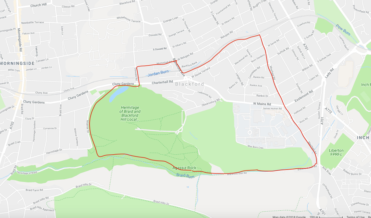
The walk should be achievable by most reasonably able-bodied people on foot or by bicycle; there are a couple of sections which would be challenging with a wheelchair or pram. The route up to the summit of Blackford Hill from the Observatory Car Park is pretty easy on a broad path, and doesn't really get very steep. If you start from the other parking spot at Blackford Pond, it's a much steeper climb up. In winter when snow is on the ground it can be quite treacherous, and there is the added hazard of people having fun on sledges. The summit of Blackford Hill is a favourite spot to watch the Edinburgh Festival and the Hogmanay firework displays. You can start anywhere, but car drivers would be best starting and finishing at one of the parking coordinates given, to make a circular walk. As we go along, I’ll give you some brief information about the area and its history. Enjoy!
The most dominant feature of the area is Blackford Hill, along with the Royal Observatory. Most of the area is devoted to houses of the late Victorian and Edwardian ages, and is composed mainly of villa-type dwellings, with a few tenements and terraces of the type seen in Marchmont and Sciennes. However, at one time, as with Grange, Sciennes and Marchmont, the area was well away from the City of Edinburgh and the land was wild and unpopulated except for some sheep farming. There was once a Blackford Loch (not connected at all with the modern day Blackford Pond); it lay on the course of the Jordan Burn in the area now bounded by Blackford Avenue, Mayfield Road, West Saville Terrace and Relugas Road. The first mention of the area of Blackford appears on records in 1631, when the lands hereabouts were known as 'Champanyie' or 'Champaye' or 'Hampanay'. The only reason for this I can find is that it was considered fashionable in those days to give things French names! My French is not great but roughly this translates to 'countryside'. In 1598, Edinburgh magistrates had passed an Act which reserved a strip of land '12 ells in width to and from the Pow Burn for the use of the town': this area of land corresponds roughly to where Blackford Avenue is now. In 1719, Archibald Brown of Plewlands purchased a parcel of land of 38 acres lying to the south of the mansion of Wester Grange from Dr J Forrest MD, then in 1723 Brown gifted the land to his nephew. For a time this land was known as 'Blackford Estate'. In 1760, the Browns sold the estate to Henry Trotter along with a part of Blackford Hill, and it stayed with the Trotter family for many generations. Richard Trotter married a daughter of the Oswald family in 1836, so you can see the historical origins of many place names hereabouts, with Oswald Road forming the West boundary of the estate. Blackford House itself is no more to be seen but there are old drawings of it. It stood on the south bank of the Jordan Burn, roughly where Charterhall Grove now is, in the midst of farm lands. One of its most notable residents was the eccentric Miss Meenie Trotter, who lived in it during the 2nd half of the 19th century. Apparently she used to bathe in the burn then take a walk over the hill every morning before breakfast. I hope with this easy multi to take you on a leisurely stroll around the more interesting features and give you some insight into the historical background.
WAYPOINT 1 Hill Fort (Summit of Blackford Hill) N 55° 55.384 W 3° 11.700
What a fabulous view! Even in poor weather there will be something to see. Blackford Hill is one of the Seven Hills of Edinburgh and is 164m high. You can tell it's a popular walk if the erosion of the path is anything to go by. Blackford Hill is the northern continuation of the Lower Devonian Pentland Hills volcanic rocks and was created from the oldest rocks in the city, when lava flowed across a red sandstone desert 400 million years ago. The hill is classically 'crag-and-tail' shaped, formed from a vast ice-sheet moving eastwards, scratching, scarifying, exposing the rocks into escarpments, gouging hollows and valleys. I wonder how many visitors enjoying the panoramic views have noticed the evidence of a prehistoric fort: most likely Iron Age, and about 2,000 years old. 2 circular ramparts are still visible in places. It's about 300 yards west of the Observatory buildings. Immediately to the east, you may be able to make out the remains of 4 circular dwellings, about 8m in diameter. 'Cup and Ring' marked rocks were discovered here and are now on display in the Royal Museum of Scotland, and the whole hill is under the protection of the Scheduled Ancient Monument Act. The earliest history we know is that this land was owned in 1165 by Sir Henry de Brad, Sheriff of Edinburgh. (I wonder if 'Brad' was an earlier version of 'Braid'). He probably had a house at one time near where Midmar Avenue now is.
The coordinates take you to a circular direction indicator
CLUE 1: How far is it to the Bass Rock? (answer in km)
WAYPOINT 2 Memorial Bench N 55° 55.337 W 3° 11.362
The picnic bench commemorates a talented junior doctor who died in a freak skiing accident at the age off 25.
CLUE 2: Add together the 2nd and 5th digits
WAYPOINT 3 Memorial Bench N 55° 55.397 W 3° 11.209
This is a nice place to sit and enjoy the view to the east of the Royal Observatory. The observatory started life on Calton Hill in 1822 and then moved here to Blackford Hill in 1896 thanks to the generous donation of the Earl of Crawford, who moved his personal astronomy equipment from Aberdeen. It's well worth taking the tour, or even attending one of their evening lectures when they will often open the dome and show you the night sky.
CLUE 3: How many border terriers?
Right, those 3 were the most physically challenging section, and now you can either go back to your car to continue the quest, or enjoy a longer walk to complete this multi. The remaining clues are on level ground, thank goodness!
WAYPOINT 4 Harrison's Arch N 55° 55.491 W 3° 10.901
Now what a bizarrely grand structure to the glory of someone you've probably never heard of! So who was Harrison? Well, he was Lord Provost Sir George Harrison who brokered the purchase of Blackford Hill from the Trotter family in 1884 at a cost of £8,000. That's about £10 million today. People liked this so much that the council built this splendidly ostentatious memorial to him. Ever since then, Blackford Hill and the Hermitage of Braid have been a much-loved public open space.
CLUE 4: Note: these coordinates take you to one side of the monument, as I don't want you standing in the middle of the road! You need to look up at the centre inscription. How many words in the top line of the Latin inscription?
WAYPOINT 5 King's Buildings N 55° 55.358 W 3° 10.520
This is the 'Science' campus of the University of Edinburgh and is the home of the scientists and engineers. It was built around 1919 on the site of West Mains Farm. As you walk around, you will notice that the buildings are named after famous scientists; and since 2014 so are the roads! There's a cafe in the James Clark Maxwell building called the Magnet Cafe. I wonder why....However we are going to admire not just one, but two, interesting sculptures by the famous sculptor Paolozzi. Sit down on the steps at the coordinates and read the plaque.
CLUE 5: One of the statues is standing on its head. Which one? Answer = no. of letters
(please note: this is a temporary place for the statues during the building works; I'll change the coordinates when they are moved back to their original position outside the School of Biological Sciences)
WAYPOINT 6 Reid Memorial Church N 55° 55.587 W 3° 11.117
Reid Memorial is a rather beautiful building and has served the community since 1936. Its name comes from William Reid, a successful Edinburgh businessman who's son died without heirs so left his money to build the church in memory of his father. The building looks older than it really is owing to its cathedral-like Arts and Crafts Gothic design. It is a category 'A' listed building. In addition to its main use as a place of worship for the Church of Scotland, the halls are used by many local community groups.
CLUE 6: You will see 2 ornate lamps on stone pillars, one on each side of the main gate. How many SMALL panes of glass are there? (count them carefully! don't rely on multiplication!)
WAYPOINT 7 Blackford Hill Station N 55° 55.630' W 3° 11.222'
At these coordinates you will find yourself standing on the bridge over the railway line. Now try to imagine what it must have been like when this was a busy, thriving suburban station with pens for the sheep being transported from their grazing on Blackford Hill to market. It was called Blackford Hill Station and opened in 1884 and closed in 1962. It was on the Edinburgh Suburban and Southside Junction Railway and this station was in between Newington Station and Morningside Road Station, both also now closed. The line took a circular route through Waverly Station: one clockwise and the other anticlockwise. Although the station itself is now closed, trains do still use the line: for freight only, in order to avoid freight trains having to go through the main passenger stations at Waverly and Haymarket. From time to time a passenger train gets diverted along here, much to the consternation of the passengers on board! Have a look over the bridge and try to work out where the platform was. (I think the Cat Clinic was probably the ticket office but not sure).
CLUE 7: The bridge has an identification code with 4 numbers. What is the last one?
WAYPOINT 8 Entrance to Hermitage of Braid and Blackford Hill Local Nature Reserve N 55° 55.544 W 3° 11.586
Well that's a bit of a mouthful isn't it! We just call this entrance 'Blackford Pond'. The coordinates take you to an information board straight ahead. However if you go through the gates and turn right past the swings you'll come to the entrance to the pond area, where you can see some of the best fed ducks and swans in the country. You will be walking in the footsteps of Robert Louis Stevenson, who used to walk here too. You don't need to go there to complete this multi but it's worth it to read the informative notices about the wildlife of the pond. Blackford Pond is actually man-made. It was created by our Victorian ancestors in a glacial hollow and is a 'eutrophic' pond: this means that the water has no natural inflow but it is formed from rain water contaminated by run-off from the neighbouring allotments which, combined with the copious amount of bread fed to the ducks, causes the occasional formation of algal blooms. The pond used to freeze hard enough so that in 1848 the Waverley Curling Club started using it for curling and skating. When the ice was strong enough to take the weight of a Bonspiel (curling contest), the Morningside shops would put a notice in their windows to let people know about it! This certainly occurred during the harsh winter of 1900. Peedieduchess has never walked on the ice herself, but enjoys watching the comical antics of the swans trying to 'take off' from the ice in winter. Less comical was dealing with a toddler falling into the stinking water...
CLUE 8 What do large toads sometimes eat? (number of letters)
Now you have to do your sums.
I hope you have enjoyed your bimble, which has taken you to some places of interest in Blackford.
The cache can be found at:
N 55º55.ABC W 003º11.DEF
Where:
A = (clue 2 plus clue 3) divided by 3
B =(clue 6 minus clue 1) plus 1
C = (clue 7 plus clue 8 plus clue 4) divide by 3
D = clue 2 minus clue 5
E = clue 1 minus (3 x clue 2)
F = (clue 6 divide by clue 4) minus 1
Checksum: your 6 numbers should add up to 30.

MAXIMUM STEALTH REQUIRED PLEASE TO AVOID MUGGLE INTEREST
Congratulations Elpth, First to Find!
Congratulations wee-z, Second to Find!