Birl: 'To spin, revolve rapidly, or whirl around.' It’s also a technique used by bagpipe players, and you can take your bagpipes with you if you like, but you may receive complaints if you actually play them!
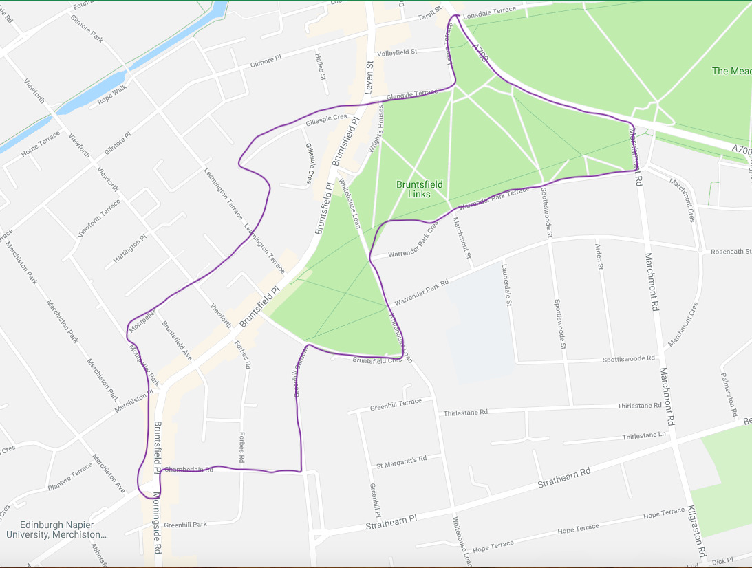
Bruntsfield: An affluent area of South Edinburgh characterised by tenement dwellings and mansion houses, surrounded by Merchiston, Morningside, Churchill, Greenhill, Grange, Marchmont and Tollcross. There are many coffee shops, delicatessens, chocolatiers and boutiques for the shopper looking for something ‘different’, giving it a ‘village’ atmosphere. These lands were once on the Burgh Muir, a part of the Great Forest of Drumselch which stretched north-south from the Burgh Loch to the Braid Hills, and east-west from the Drum at Gilmerton to Easter Craiglockhart Hill. It is believed that the 'comon mure' was gifted to the city by King David I in 1143, but proof is hard to find, since most records were lost when the Earl of Hertford set fire to the city in 1544. It was originally part of the barony of Colinton, and the original name was Brounysfelde, after the first known owner, Richard Broun of Boroumore. He was the elder brother of Alan de Lawedre of the Haltoun House family. In 1381 the Crown during the reign of Robert II granted the lands of ‘Burrowmure in Edinburghshire’ to William Lauder. Then in 1695 the estate was sold to George Warrender. The original house still exists in the grounds of James Gillespies School: it is included in one of my other historical multis, Meander Through Marchmont. Bruntsfield Links was the site of a huge assembly of people in 1832: 15,000 tradespeople gathered to celebrate the Great Reform Act which gave men of property the vote. A further 30,000 people joined in the singing of 'God save the King'. The map below is not intended to mark out the boundaries of Bruntsfield, which have become a bit 'fluid' over the years; rather, it outlines roughly where you'll be birling. It's amazing how much of interest is to be found in this small area, and your CO has had some difficulty deciding what to include and what to leave out! There is so much to see.
This is one of a series of sightseeing history tours around the leafy suburbs of south Edinburgh. The others are:
- Gambol Through the Grange
- Mosey Through the Meadows
- Meander Through Marchmont
- Saunter Through Sciennes
- Bimble Through Blackford
Once you've done them all, you can try for the bonus cache: Jig Through Half a Dozen History Multis
OK, Let's birl!
WAYPOINT 1 Bruntsfield Links N 55° 56.410' W 3° 12.182'
You are standing at an information board describing the world's oldest short-hole golf course. But did you know that you may have just walked over the bones of a plague victim? Between the 15th and 17th centuries Edinburgh had repeated epidemics of the plague, resulting in, for the time, quite creative public health measures. One such outbreak took half the population of Leith:
All known or suspected plague victims had to be reported to the authorities within 24 hours. Horse- or hand-drawn wooden carts conveyed the hapless victims out to the Burgh Muir. These primitive ambulances were preceded by 'Bailies of the Mure', voluntarily recruited men wearing black or grey tunics. Once on the Muir, the victims' clothes were washed in huge cauldrons of boiling water in an attempt to disinfect them and bed gowns were issued. The patients were taken to wooden huts around the Chapel of St Roque (the patron saint of plague victims) at the west end of the burgh – which used to be on what is now the site of the Astley Ainslie Hospital – or to the Chapel of St John the Baptist in the Sciennes district at the east end. Many victims never reached these early hospitals but died en route and were buried by the wayside, hence the human remains unearthed in private gardens in the wide area which was once the Burgh Muir.
We shall visit one of the victims later, at waypoint 10. Another snippet of historical information: in 1513, King James IV reviewed his troops before they set of for the Battle of Flodden. Did you notice that this green area is different from the Meadows, just to the north, on the other side of Melville Drive? Yes? Did you notice that whereas the Meadows is pretty flat and level, the Links here are not: its a bit bumpier. This is because the Meadows was once under water, it was the Burgh Loch, and here at the Links, it was not part of the Burgh Loch but was always solid ground of the Burgh Muir, an area of oak forest. This somewhat uneven ground, as well as being a burial place for plague victims, also had a quarry from about 1599 for 200 years, with the stone being used for buidlings in the Old Town. A happy consequence of this bumpy ground is that it lent to the creation of the worlds first known short-hole golf course. Here's another snippet: Sir Walter Scott, before he became a famous author, served as a volunteer in the cavalry regiment and in 1798 he applied for permission to train his men on the links. Guess what?' no way...because it would get in the way of the golfers!
CLUE 1: What is 'par for the course'? 10?
WAYPOINT 2 The Golf Tavern N 55° 56.393' W 3° 12.212'
Established in 1456, one of the oldest hostelries in Edinburgh, but there may have been a tavern here as early as 1399. It used to be called the Golf Hotel and was the clubhouse of the Royal Burgess Golfing Society of Edinburgh from 1735 till it moved to Musselburgh in the 1800s. Staying with the drinking theme, there was also somewhere around here a hostelry called 'Rare Maggy Johnson's'. She was the subject of an elegy by Allan Ramsay extolling the delights of visiting her inn after a hard day on the golf course.
CLUE 2: How many WORDS are inscribed beneath the anchor above the door?
WAYPOINT 3 The Friends' Stone N 55° 56.424' W 3° 12.182'.
This should be self-explanatory. Actually they originally wanted to plant a tree, but for cost reasons settled for a stone. A very nice one it is too!
CLUE 3: The Friends of Parks was launched on 2? February 2001
WAYPOINT 4: Barclay Viewforth Church N 55° 56.445' W 3° 12.199'
The coordinates take you to the steps on the corner, but do take the time to have a look at the rest of the building. Barclay Viewforth Church (as it is now) is an almagamation of a number of churches over the years, the most recent being Viewforth Church in 2009. The Church was built in 1864 at a time when it was still surrounded by forest well outside the city; but the 'feuing' of Marchmont and Sciennes was underway and led to the building of other churches to cope with the rising popultation. Originally known as “The Barclay Church” after Mary Barclay whose legacy paid for its building, its design by Frederick Thomas Pilkington was quite controversial owing to its massive, intricately ornamental 250 foot steeple. Its Franco-Venetian Gothic design was once described as " a collection of rhinoceroses and giraffes at a watering hole, their rumps backing on to the Links." The main road to London ran along the line of Barclay Terrace, past the wood burners’ cottages at Wright’s Houses, which stood on either side of the Golf Tavern.
CLUE 4: How many angels can you see? Count the faces and divide by 2.
WAYPOINT 5: Scottish War Blinded N 55° 56.427' W 3° 12.290'
You should have crossed over Bruntsfield Place into Gillespie Crescent. What you are looking at is the administration offices of the Scottish War Blinded organisation for veterans with sight loss. I've brought you here because this building is on the site of the original Burgh Muir Castle, also known as Barganie House. It once belonged to the Napier family (a different branch of Napiers, not the Napiers of Merchiston of logarithms fame), and was a 14th century keep of picturesque design adorned with heraldic devices. It was also known as 'Wryttes-Houses' or 'Wrychtishousis'. The origin of the name 'Wrychtishousis' is a mystery but may be to do with the adjacent houses surrounding the peel tower in which lived the 'wrights' or joiners who were engaged in felling the trees of the Burgh `Muir. In 1508, James IV granted a charter to permit the townspeople to cut down the trees and to use the timber to extend the frontage of their Old Town houses by 7 feet. As those houses began to look more wooden than stone it's no wonder that there are so many very narrow streets in the Old Town! In an extraordinary act of cultural vandalism, the house was demolished in 1800, and later also the workers' houses to make room for a road. The only remaining evidence of those houses are the ones you saw at waypoints 2 to 4. Henry Cockburn claimed that the historic and picturesque edifice had been "brutally obliterated" while "the idiot public looked on in silence". Four of its decorative stones are supposed to be still visible in Gillespie Crescent but I'm afraid I can't find them. The empty plot was then used to build Gillespies Hospital. James Gillespie, rich from his tobacco dealings during the American War of Independence, donated £12,000 to build the hospital and £2,700 to found a charitable free school for the education of 100 poor boys. The school moved to Warrender Park Crescent then later to Warrender Park Road. Read more about this in my multi 'Meander Through Marchmont'
CLUE 5: Look for the Scottish War Blinded sign. How many large bolts are holding the sign onto the metal fence?
WAYPOINT 6: Muriel Spark Walk N 55° 56.225' W 3° 12.300'
Here you can have a little rest on a wood and stone bench. Muriel Spark was Edinburgh's best known female author. Born Muriel Camberg, she lived in Bruntsfield Place and went to James Gillespies High School for Girls, where she found inspiration for her most loved character, Miss Jean Brodie. This walkway was named after her in June 2018 to mark the centenary of her birth; there are also some steps named after her in the Grassmarket. All 22 of her novels were republished in 2017/18 as centenary editions. This place was also used as a location for the filming of 'The Pride of Miss Jean Brodie'. Did you know that Muriel Spark once worked for British Intelligence, writing propaganda for MI6?
CLUE 6: What is a duty? (no. of letters in the word)
WAYPOINT 7: Bruntsfield Evangelical Church N 55° 56.299' W 3° 12.415'
Designed by J Russell Walker in 1882, this listed building is in early French Gothic style and its spire is an important landmark. There were many churches built in Edinburgh around the same time, all trying to outdo each other in clever or unusual designs; e.g. Braid church with its octagonal auditorium and Italian influenced interior; Morningside and Mayfield churches in a later French style. Once into the 20th century, churches returned to a simpler style. On the way to the next waypoint, you'll walk past the end of Admiral Terrace: no. 5 was used as location of Miss Jean Brodie's home in the movie about her. You'll also walk past some posh flats, complete with charging points for electric cars; this building used to be the Bouroughmuir High School. The history of this school is intertwined with that of James Gillespies, as they moved in and out of each other's buildings over the years. Notable almunni: Sarah Smith, BBC journalist; Annette Crosbie, actress; Christine Graeme, SNP politician; Fraser Watt, cricketer. In 2018 the school was sold to CALA housing for £14.5M and they moved to a new building down the road.
CLUE 7 How many complete circles are there above the door, but below the name of the church?
WAYPOINT 8: Bruntsfield Public School N 55° 56.236' W 3° 12.605'
You are now in Montpelier. Sounds French, doesn't it? It's a small part of the old 'Wright's Houses' and may have got the name due to St Roche, the saint who fought against the plague, having been born in Montpellier. The land was described thus: "about 7 acres of Ground, to be feued for villas, at the head of Bruntsfield Links, immediately west and adjoining to the present Lord Provost's house, commanding a most extensive and beautiful view, and by the physicians called the Montpelier of Scotland" [Edinburgh Evening Courant, 26 Jan 1811]. It was designed by the architect to the schools board, Robert Wilson, in 1894. He was the predecessor to Carfrae who later designed Boroughmuir school. It included an integrated Janitor's house!
CLUE 8 NO question to answer here, its a quieter route to the next waypoint
WAYPOINT 9: John Livinstone's Tomb N 55° 56.064' W 3° 12.361 I promised you earlier that I'd take you to meet a victim of the terrible 'black death' that swept across the country over a period of about 200 years. To do so we stray slightly out of Bruntsfield into Greenhill, a small district tucked in between Marchmont and Bruntsfield. It was of course once part of the Burgh Muir, and was one of the lots of land parcelled off by the city magistrates in 1586. About 8 acres was bought by Thomas Aitkenhead, a skinner or glover of the merchant class. This small district has many impressive villas, each of unique design, and many distinguished former residents, including John Livingston, an apothecary who aquired Greenhill in 1636. He died of the plague in 1645 and here is his tomb. Go through the low gate and through the next gate into the tomb. and try to imagine what it was like in those days, when half the population of Leith succumbed to the black death, and even the soldiers at the castle left their posts to escape the city. Turn round to find a white notice to the left of the gate.The inscription on the gravestone reads:
This Saint whos Corps lyes buried heir
Let all posteritie admoir
For upright lif in Godly feir
When judgements did this land surround
He with God was walking found
For which from midst of fers he's cround
Heir to be interred. Both he
And friends by Providence agrie
No age shal los his memorie
CLUE 9: What is the last number on the white notice board?
WAYPOINT 10: Eric Liddell Centre N 55° 56.033' W 3° 12.593'
Here you are at 'Holy Corner', a well known crossroads which marks the boundary between Bruntsfield and Churchill/Morningside. Above the coffee shop on the south west corner you can see the old sign 'Burghmuirhead'. Here is what was written by Robert Louis Stevenson in his 'Edinburgh: Picturesque Notes':
: From Boroughmuirhead, where the Scottish army encamped before Flodden, the road descends a long hill, at the bottom of which......issues at once in to the open country'.
The churches that give it the nickname of 'Holy Corner' are: Christ Church, Morningside United Church, Edinburgh Elim Pentecostal Church and Morningside North Parish Church, which was renamed Eric Liddell Centre in 1992 in memory of the Olympic gold medallist and missionary who was portrayed in the 1981 Oscar award-winning film “Chariots of Fire”. Eric Liddell lived in this area of Edinburgh whilst studying at Edinburgh University in the early 1920s. The centre is now a community resource; if you are here during opening hours, do go inside where you will find a nice coffee shop, toilets and free wifi. The centre is open from 9am to 9.30pm Monday to Friday and 9am to 5pm on Saturdays; the cafe is open from 10am till 4pm.
CLUE 10 Sit on the bench. Which company of Girl Guides is mentioned? ?3rd
Now you can stay on the bench to do your sums. Or go inside to the cafe.
I hope you have enjoyed your birl, which has taken you to some places of interest in Bruntsfield, with a little intrusion into Greenhill. I apologise for omitting Bruntsfield Hospital: it is included, for route convenience, in another multi, Meander Through Marchmont
A note about parking: there are no public carparks in the area. On-street parking is pay and display, with charges applicable Monday to Friday from 08:30 till 17:30. At other times and at weekends there is no charge, but it is advisable to avoid resident permit spaces.
A note for wheelchair users: I think most of the route could be done in a wheelchair, however there are some roads without dropped pavements, and some rather uneven surfaces and narrow pavements, hence the 'T' rating of 1.5.
The cache can be found at:
N 55º56.ABC W 003º12.DEF
Where:
A =clue 9 minus clue 3 minus clue 7
B =clue 6 minus clue 5
C =clue 1 minus clue 3
D =clue 2 plus clue 7
E =clue 4 add 1
F =clue 10 minus clue 4
Checksum: your 6 numbers should add up to 19

MAXIMUM STEALTH REQUIRED PLEASE TO AVOID MUGGLE INTEREST
Please note that there is no need to go through any gates; the owner of the house that overlooks the hiding place knows about the cache but please be discreet.
Congratulations Devious_DwarferKev First to Find! His prize was presented in the warmth of the Eric Liddell Centre cafe.