Look Maar, No Mountain!
A "maarvelous" earthcache located in Mangere, Auckland, by funkymunkyzone and geocoinsnz.
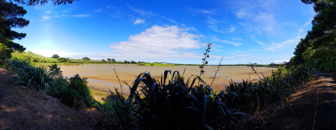
Mangere Lagoon
Mangere Lagoon is a lagoon connected to the Manukau harbour. Roughly 600m across and oval in shape, it is an example of a maar volcano - one of several in the Auckland Volcanic Zone, with other examples located also in the vicinity, the low lying area around Auckland Airport.
Mangere Lagoon's history has been somewhat checkered - it was first drained in order to convert to pasture in the 1930s and then in the 1950s modified by earthworks in order to create ponds for sewage sludge. Ultimately the nearby wastewater treatment plant was upgraded and in 2003 the lagoon was restored as a tidal lagoon, the sludge removed, and the scoria cone partially restored as a nesting site for bird life.
Maar Volcanoes
A maar is a volcanic explosion crater that is generally broad and shallow with steep sides. They are formed by a phreatomagmatic eruption (a violent explosive reaction when molten lava or magma comes into contact with groundwater). Typically post formation the crater will at least partially fill with water, giving a characteristic shallow lake.
The name "maar" comes from a Moselle Franconian dialect word used for the circular lakes of the Daun area of Germany (where there are approximately 75 maars in the volcanic zone).
Scientists believe that maars form above diatremes - a volcanic pipe through which magma rises to the surface coming into contact with ground water. Sudden super heating of the ground water causes massive expansion, blasting out a crater on the surface and surrounding the crater with tephra and fragments of rock torn from the diatreme chimney.
This Earthcache
In order to log this earthcache as found you need to visit the site and complete an educational task. The answer to the following questions should be emailed to the cache owner by using the link at the top of the cache page. Do not include any spoilers to the answers in your online log.
1. The published coordinates will bring you to a junction between a path that follows the circumference of the maar, near water level, and a path that goes from the lower level to the top of the crater rim and out to a nearby road. Please estimate the height of the crater rim. If your device is capable, you can measure the height difference between this spot and the top of the path, otherwise just walk up the path and estimate the height difference.
2. With your answer to the first question in mind, and observing the surrounding landscape (and nearby the looming Mangere Mountain), describe how this volcano differs to the other obvious volcanoes you see around Auckland, including Mangere Mountain.
3. Part way up (or down) the path you will see rock exposed on the up hill side of the path - for example at the "Stage 2" waypoint.
a. How can you tell this rock is volcanic in origin?
b. Can you see evidence of explosive expanding gas in the rock here or further along the path?
c. Do you think the magma here was of high viscosity (like honey or oil) or low viscosity (like water), and why do you think so?
4. Take a photo of the maar in front of you from the published coordinates, or anywhere along the walkway around the lagoon, including yourself, your GPS or some other personal item, and upload it with your online log.
You can log this earthcache as soon as you have visited and gathered your answers to the above questions. You need to email these answers to the cache owner within a week. Logs that do not accompany such an email, or do not have a photo, will be deleted.
 |
First to learn something from maar:
kiwicouple
|