
 n diciembre de 2021 se produjo de nuevo una crecida enorme del río Ebro. Aquí es cuando la gente vuelve a hablar del nivel freático del suelo. Y aunque todos lo estudiamos en EGB (o en primaria, los más jóvenes) y probablemente sabemos que tiene que ver con las aguas subterráneas, quizá alguien haya olvidado a qué se refiere exactamente ese término.
El nivel freático viene marcado por la profundidad que alcanza la capa superior del agua acumulada en el subsuelo. En ese punto es, además, la presión es similar a la atmosférica.
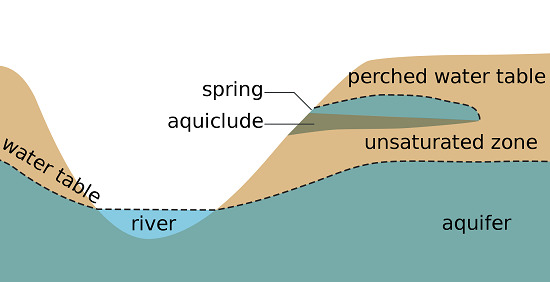
Bajo nuestros pies, a distinta distancia de la superficie, puede haber acumulaciones de agua que se forman por filtraciones. Cuando ese agua encuentra un estrato impermeable queda retenida y se forma así un acuífero. Sobre él, habrá una capa de tierra seca o con muy poca humedad.
El acuífero, por contra, es una zona saturada de agua. Esta, a veces encuentra un camino de salida y se convierte en un manantial. Otras, podemos recuperar el agua mediante la excavación de un pozo. El agua freática, en principio, no sirve para el consumo humano, aunque sí puede usarse para regar el campo o para limpiar las calles, por ejemplo. Además, en zonas con problemas de sequía -y tras su posterior tratamiento- es una alternativa para el suministro de agua potable a la población.
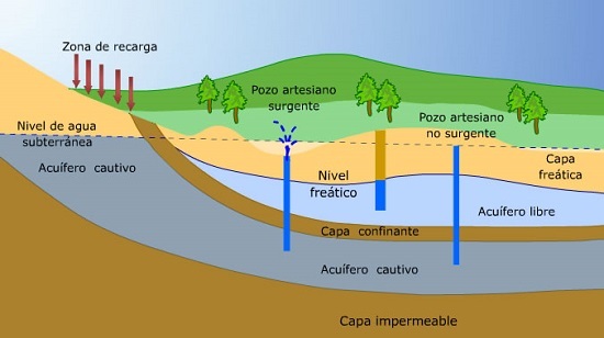
La existencia de estas acumulaciones de líquido viene muy determinada por la pluviosidad y, en el caso de lo ocurrido estos días, por el volumen de agua que transportan los ríos cercanos. Con la riada, el agua del Ebro ha empapado el subsuelo y ha hecho que la capa freática llegue hasta la superficie o muy cerca de ella. Por eso se han inundado muchos garajes y por eso, como explican los bomberos, no tiene sentido intervenir hasta que el freático baje: por mucho que achiquemos el agua, si todo el subsuelo de alrededor está empapado, el agua volverá a colarse. Hay que esperar a que el nivel freático baje y será entonces cuando puedan limpiarse los destrozos sin riesgo.
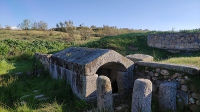
En el paraje en el que nos encontramos, podemos encontrar una fuente de la que hasta hace poco tiempo manaba agua por filtración. Es un lugar que tiene la historia del pueblo de Brunete. Según el cartel tendrá una antigüedad de un siglo. Actualmente, salvo cuando se producen grandes lluvias la fuente permanece seca precisamente por la bajada del nivel freático de la zona.
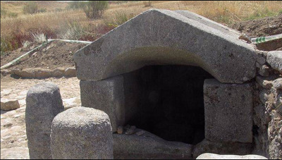
Fuente del Caño Nuevo
━━━━━━✧❂✧━━━━━━
Registro del cache virtual
Para registrar este cache virtual tenéis que realizar dos tareas:
- En primer lugar, tomaros una fotografía en la fuente del caño nuevo que se encuentra en las coordenadas del cache. Debéis mostrar vuestro nombre de equipo y, opcionalmente, os podéis asomar en la fotografía. Después, subid la fotografía en vuestro registro.
- En segundo lugar, tendréis que poner en vuestro registro por qué creeis que la fuente no tiene agua.
¡Muchas gracias por vuestra visita!

 n December 2021, the Ebro river swelled again. This is when people talk about the groundwater table again. And although we all study it in EGB (or in primary school, the youngest) and we probably know that it has to do with groundwater, perhaps someone has forgotten what exactly that term refers to.
The phreatic level is marked by the depth reached by the upper layer of the water accumulated in the subsoil. At that point is, in addition, the pressure is similar to atmospheric.
Under our feet, at different distances from the surface, there may be accumulations of water that are formed by seepage. When that water finds an impermeable layer, it is retained and thus an aquifer is formed. Above it, there will be a layer of dry soil or with very little humidity.
The aquifer, on the other hand, is a zone saturated with water. This sometimes finds a way out and becomes a spring. Others, we can recover the water by digging a well. The groundwater, in principle, is not used for human consumption, although it can be used to irrigate the fields or to clean the streets, for example. In addition, in areas with drought problems -and after its subsequent treatment- it is an alternative for the supply of drinking water to the population.
The existence of these accumulations of liquid is highly determined by rainfall and, in the case of what happened these days, by the volume of water transported by nearby rivers. With the flood, the water from the Ebro has soaked the subsoil and has caused the water table to reach the surface or very close to it. That is why many garages have been flooded and that is why, as the firefighters explain, it makes no sense to intervene until the water table drops: no matter how much we drain the water, if all the surrounding subsoil is soaked, the water will seep in again. You have to wait for the water table to drop and that is when the damage can be cleaned up without risk.
In the place where we are, we can find a source from which, until recently, water flowed by filtration. It is a place that has the history of the people of Brunete. According to the poster, it will be a century old. Currently, except when heavy rains occur, the spring remains dry precisely because of the lowering of the water table in the area.
The Fountain Caño Nuevo
━━━━━━✧❂✧━━━━━━
Virtual cache registration
To register this virtual cache you have to perform two tasks:
- First of all, take a picture at the GZ of the fountain located at the coordinates of the cache. You must show your team name and, optionally, you can peek into the photograph. Then upload the photo to your registry.
- Secondly, you will have to put in your registry why you think that the fountain has no water.
Thank you very much for your visit!

━━━━━━✧❂✧━━━━━━
¿Has encontrado 2 o más caches virtuales en Brunete?
Have you found 2 or more virtual caches in Brunete?
Entonces puedes añadir esta imagen a tu perfil de geocaching:
Then you can add this image to your geocaching profile:

Para ello copia y pega la siguiente linea en tu perfil de geocaching:
To do this, copy and paste the following line in your geocaching profile:
<img alt="Virtual Reward - Brunete 2019/2020" src="http://www.picarax.es/GC892WE/virtualesbrunete.png" style="height:153px; width:160px" />
━━━━━━✧❂✧━━━━━━
Recompensas virtuales 2.0 - 2019/2020
Este Caché Virtual es parte de un lanzamiento limitado de Virtuales realizado entre el 4 de junio de 2019 y el 4 de junio de 2020. Solo 4.000 propietarios de caches tuvieron la oportunidad de ocultar una Caché Virtual. Para más información sobre Recompensas virtuales 2.0 en el Blog de Geocaching.
Virtual Rewards 2.0 - 2019/2020
This Virtual Cache is part of a limited release of Virtuals created between June 4, 2019 and June 4, 2020. Only 4,000 cache owners were given the opportunity to hide a Virtual Cache. Learn more about Virtual Rewards 2.0 on the Geocaching Blog.